Tuesday, August 30, 2022

Walla Walla Wash / Avalanche Canyon - 8/29/22

Rain Waterfall

Right Fork of Avalanche Canyon

View down through Kyle Canyon

Avalanche Canyon

Starting out at Echo Trailhead
Avalanche Canyon was aptly named as you see the further up the canyon you climb. Knowing this, seven strong hikers started up from the Echo Trailhead in Kyle Canyon hiking past the old ski slope and through the network of washes. Between the old ski slope and Avalanche Canyon / Big Falls Wash junction, the wash located furthest to the south wall is named Walla Walla Wash. This wash leads to a rock climbing wall called Walla Walla Wall. The wall is found just before the wash turns the corner to the left into the Big Falls Wash. All of this is on the south side of a large wash area above Mary Jane Falls Trailhead ... which is located on the north side of the washes. Are you with me so far? Maybe further description is needed!

Hiking through the brush in Hidden Falls Wash

The Old Ski Tow

Halfway down Old Ski Run

Hiking into Walla Walla Wash

Passing by Walla Walla Wall
The Six with Sticks were joined by Charlie, a capable, fun and easy going hiker from the club. We parked at the Echo Trailhead and started up the nearby trail and wash. Soon we were wading through a few weeds with an emphasis on Common Mullein, a non-native invasive plant that is blooming at this time of year. There is a vague network of trails leading across the wide wash below Hidden Falls. Hidden Falls rarely shows its stuff but, when it does, it is magnificent! Therefore, we didn't try to climb up the ravine to view the display. There was no display! Our target was a trail that led diagonally up the opposite ridge to the old ski tow machinery. Back in 1935, the Forest Service began issuing permits to build in the Spring Mountains, starting with the cabins in Rainbow Canyon. Las Vegas was growing with the construction of Hoover Dam and recreation facilities in the mountains were needed. The next year, the old ski slope was built. According to today's standards, the ski slope was very small and primitive. It used a tow rope to transport skiers up the hill. Then the skiers would hike over to the top of the ski run and let 'er rip! Remnants of the parking lot and roads at the bottom are still evident but no longer in use.

Ski Tow, Elderberries, Fossils and Wavy Walls

Teepee Shelter near Climbing Walls

Nearing the Big Falls Wash

Transitioning to Avalanche Canyon

Following the "Trail"
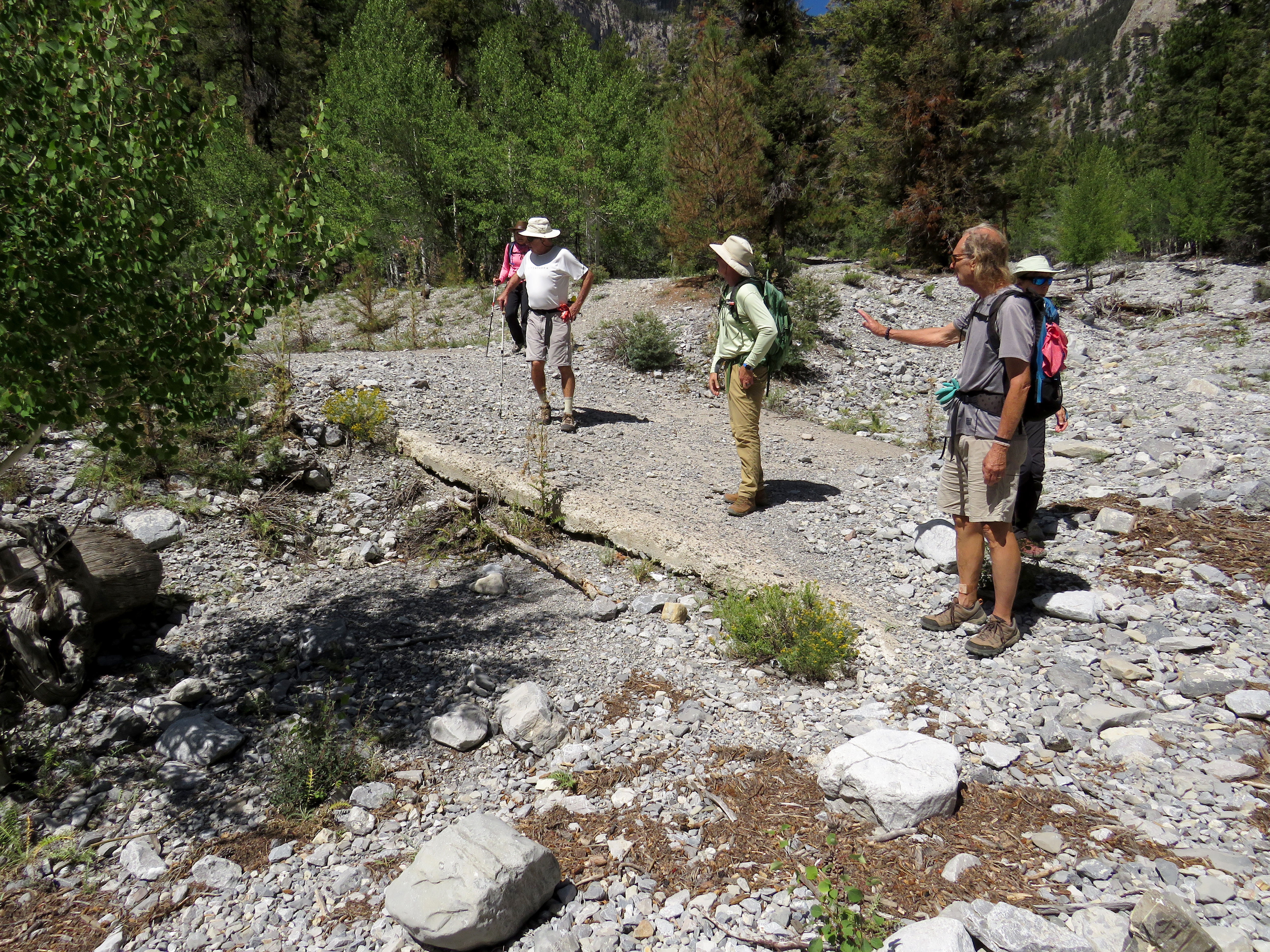
From the ski tow, we turned left onto an old trail that eventually crossed the old ski run and continued down the hill and into the Walla Walla Wash. Continuing up we came to several illegal fire rings and stick shelters. Normally, we would stop and destroy, however today, we had a whole day of exploration in front of us. On up the wash, we saw trails leading up on the left side. Jerry informed us of the rock climbing walls in the area. One, at the base of the cliffs is named Mary Jane Wall. The other is further up and named Walla Walla Wall. We hopped up onto the trail that traversed along the wash just to see how it went and ended up back in the wash before too long. We arrived at the Walla Walla Wall (I just like saying that!) then passed the familiar Big Falls Wash junction. This junction has the Walla Walla Wash (😎) coming in from the bottom, the Big Falls Wash coming in from the left and, finally, Avalanche Canyon forging ahead. To enter Avalanche Canyon, you either have to move far to the right in the wash early on or you have to climb over a berm. On our ascent, we ended up climbing over the berm and followed a use trail until we were climbing the canyon wash. (This area has always been a little confusing to me.) Anyway, we checked our GPS and found that we were on the red line.

Limestone Slab

Fun in Avalanche Canyon

Break near the Canyon filled with Avalanche Debris

Log to Duck Under

Finding our way up the Right Fork Canyon
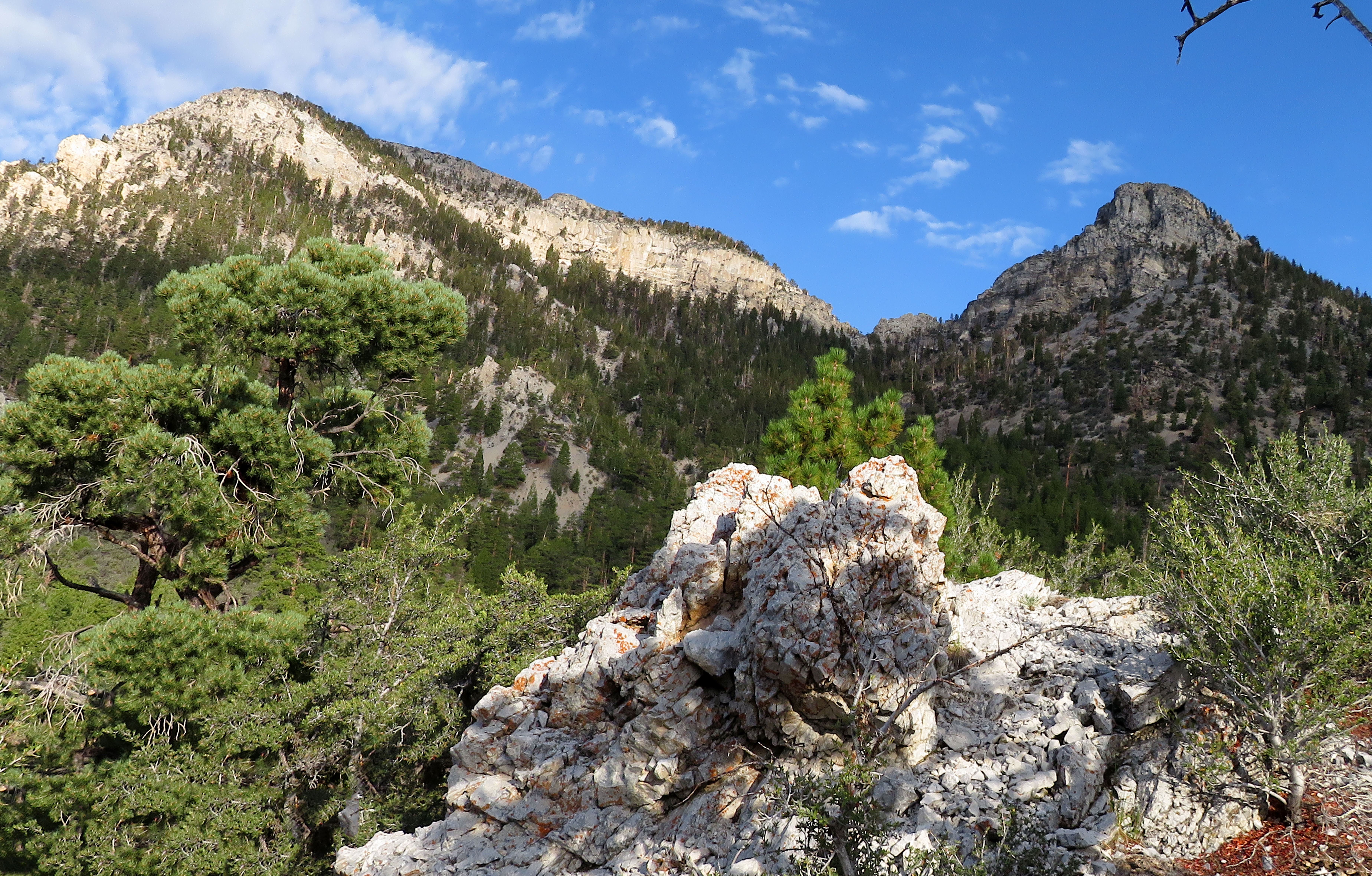
Right away, there is another wash that we did not explore coming down from the left. We'll call it the Left Fork of Avalanche Canyon. We continued up the main Avalanche Canyon wash following a "trail" where the scrambles were obvious and a little easier to negotiate. After climbing into a particular difficult spot, we decided to call it a hike. All we could see was a branch of the canyon that was literally covered with avalanche debris. Au contraire! After taking our group photo, Ralyn and I noticed a trail through the brush that led under a log and steeply up the hill on the right side. We left everyone behind to scout the trail. Quickly, we knew that I had stopped the climb too soon. There was another canyon fork turning up to the right (Right Fork of Avalanche Canyon) and it was a beautiful climb up to an alcove at the base of cliffs. We thought we could see a waterfall of some sort at the top. Returning to the group, we asked them to continue up. The reward seemed worth it. So, they jumped up and were on their way! Well, sort of. Everyone ducked under the log and began the climb to a cairn on a log. This is the right turn and up we went. After about 100 yards, the climb became even more difficult as we waded through the debris. I went to the right side of the alcoves above and everyone else, who had been delayed by a small injury, climbed to the left side. Both sides had waterfalls. The right side had more water and it came down like rain over a width of about thirty feet. The left side had a stream of water coming out of a horizontal crack in the cliff as seen below. It also had a shallow cave next to it. Above us were the cliffs of Charleston Peak.

View up to Left Alcove (Crack Waterfall above Charlie's Head)

Waterfalls in Left Alcove (Crack Waterfall)

Waterfall in Right Alcove (Rain Waterfall)

View down Canyon from Alcoves

Crazy Drop
We started our descent through the brush below the right alcove. It was a crazy drop down beside a fallen tree. There must have been a better way but we were having an adventure! Anyway, once down this particular section, we were scrambling along with the beauty of the wash and views of Kyle Canyon ahead of us. At the large wash junction, we followed the Avalanche Canyon wash on the left side. To cut off a large bend in the wash, we climbed up the hillside to follow a vague game trail. It was covered with debris and not used much so I'm not sure it was worth the detour. Back in the wash, we soon found the trail that led out to the north side and up to the old road/trail in the area. Before we reached the Mary Jane Falls Trail, we veered to the right and started descending in the middle wash / trail. This avoids the many recreational hikers that use the popular MJ Trail.

Bottom of Crazy Drop

Descending Avalanche Canyon

Following the "Trail" Down

Nice Section of Avalanche Canyon

Vague Game Trail
We descended down the wash and trail freely. At one point, we ended up on the MJ Trail but returned to the middle real estate. Crossing an old cement slab from the old ski area parking lot, we passed through the MJ Trailhead. Using the shaded trail through the woods at the bottom, we connected with the Echo Road wash just behind the pump house. This led us to the Echo Trail where we started almost 5 hours before. Fantastic and fun exploratory in an area we finally somewhat conquered! 😀

Stats: 5 miles; 1450' gain; 4.75 hours
Old Road leading toward Mary Jane Falls Trail

Descending the Middle Wash (Old Ski Parking & Road)

Hiking into Echo Road Wash behind Pump House

Echo Road Wash


Closer View of Wash Junction

Closer View of Avalanche Canyon

Tuesday, August 23, 2022

North / Black Loop (with Horse Trail Descent) - 8/22/22

Sisters Arch and Black Sister

North Sister from Sisters Ridge

Top of Deadwood Wash (Mummy Mountain in Background)

Starting up Gallium Road
There are a handful of four mile hikes in the Spring Mountains that are worth every step! (Mack's Peak and Mummy's Nose come to mind.) The North / Black Loop can be considered one of them. Brian D. is working on making a better route for the loop and we put our two cents in for this hike. We began at the Lee Canyon Chain-Up Trailhead and went up to connect with the old dirt road, Gallium Road. There is a gate across the road to keep motorized vehicles out. We hiked around the gate and started up the very washed out road as we paralleled a horse trail. The wild horses use the spring located up the road a short way. We visited the spring area noting that the pipes used to take water somewhere were exposed and broken. (More water for the horses!)

Gallium Spring

Starting Ridge Trail

South (L) and North (R) Sisters from Ascent Ridge Saddle

Climbing the Ascent Ridge
Just after the spring, there is a trail that switchbacks up to the top of the ridge on the left. We gained the ridge and began following horse / human trails along the ridge above the wash. This ridge can be followed all the way up to the Sisters Ridge. On the way, there is an open saddle area where views of South and North Sister reign ahead and Mummy Mountain rises like a ghost behind. The trail gets steadily steeper. But, it is easily followed since it never leaves the ridge top. As you near the final and steepest ascent section, you clearly see a huge arch on the right side with Black Sister in the distance. Here, is where we saw the uninvited gray cloud looming over the big black rock. Mike and Ralyn took a side trip over to the arch and through. The climb up on the other side is very difficult but they made it by barely escaping a large falling rock. Be careful here.

A Visit to the Arch

Ralyn inside the Arch

White (L) and Black (R) Sisters from Ascent

Final Ascent
A little more steep stuff and we junctioned with the main Sisters Ridge. To our left, the imposing North Sister rose pointedly. Scrambling up this peak was not planned so we turned to the right and following a ridge trail over to White Sister. The Sisters Ridge is very narrow with an excellent view of Macks Peak on one side and Mummy Mountain on the other. At White Sister, we paused for a group photo. That gray cloud was spitting at us a little and we didn't want to stick around too long. We circled around the back side of Black Sister, posed for a couple more photos, and hiked down the ridge. First we tried to go a little further out the ridge than usual but the terrain is way too steep even for a descent. Use the usual descent route on the left until you see your way over to the right and Deadwood Wash's saddle. Here, we felt safer to stop and take our break. The gray cloud was passing.

Macks Peak from Sisters Ridge

On Sisters Ridge (North Sister in Background)

Two Oranges and a Blue at Black and White Sisters

Rounding Black Sister
At this point, we were in exploratory mode. We took the trail that runs down the right embankment of the drainage. This time, we followed the clear and imagined trail straight toward a saddle that rose across from us on the opposite ridge. The trail appeared very old and unkempt. There was a section of deadfall to find your way through and a swath of dead standing trees as well. A good machete would do the trick! We stayed the course toward the saddle and, as we neared, the trail became much clearer. The climb to the saddle was easy. We took in an interesting view of Lee Canyon and began following another trail diagonally down. This trail zigged and zagged down the hill in small scree, bushes and trees. It was also somewhat washed out in places.

Posing on Black Sister Ridge

A very steep Descent

Following the Horse Trail

Horse Trail nearing the Saddle
Eventually, we found our way into the pine glade at the bottom. The wash that cut in front of us led down to the trailhead but we knew it fell into the parking lot steeply and slippery. So, we followed an old dirt road around to the left to the lower end of the trailhead and Lee Canyon Road. This is where we dropped into the parking lot much easier. Short and very sweet with fantastic views all around. However, we do need to enhance that old trail so that it can be used again. 

Stats: 3.4 miles; 1675' gain; 4 hours

The Saddle

Lee Canyon view from the Saddle

Entering the Pine Glade