|
| Foxtail Spring & Waterfall |
 |
| The Sisters Ridge above snowy road from Spring |
 |
| Lee Peak above Ski Slopes and Upper Bristlecone Parking from Loop Trail |
 |
| Starting up the Foxtail Ridge Road |
Often when it is a holiday or any other really busy day, our hike will take us up to the Foxtail area. Here, you can find a challenging ridge, a beautiful spring, Pioneer Rock, and the abandoned girl scout camp named Camp Foxtail. Today, Memorial Day, six of us parked at the traffic circle on Lee Canyon Road and headed toward the picnic area on the south side of the road. Before we entered the picnic areas, we turned right to follow a horse trail up to the top of Foxtail Ridge. Up there, we followed an old service road up to Lee Canyon's water tank and Camp Foxtail's fireside amphitheater. A trail led us down to the main camp and its dining hall. The girl scouts no longer lease the property from the forest service.
 |
| Some sights at Camp Foxtail |
 |
| Aspen-lined road to leading to Spring |
 |
| Climbing road through Snow Patches |
 |
| Nearing the Wash Crossing |
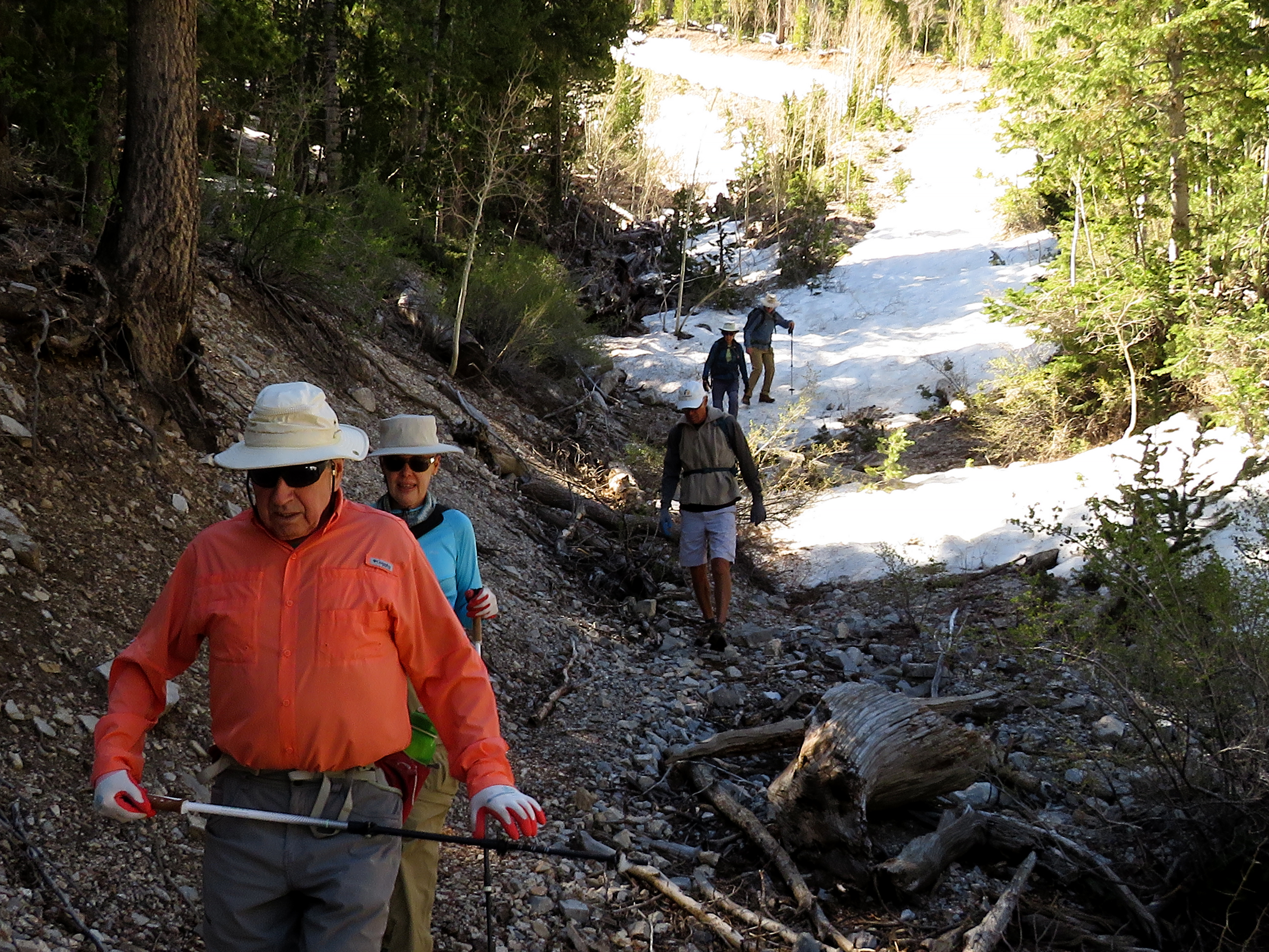
On the left of the dining hall, a road starts uphill through the rest of the camp. We followed it up past the turnoff to the left, through the aspens and past the camp water/ utilities station. Here, the road continues up going steeper and steeper. This is where we began to hit large snow patches. We reached the wash crossing and I decided to put on my microspikes. The snow was steep and few people had been there blazing the trail before us. It was my first time wearing them and I decided that I love them! We crossed the wash, climbed the first hill then turned to the right. Weaving our way through the woods, we found the somewhat less steep parallel road which was completely snow covered.
 |
| Kay shows off her MicroSpikes after crossing Wash |
 |
| The parallel road is snow-covered, too! |
 |
| Steep Snow up to Spring |
 |
| Foxtail Spring Waterfall |
Our steep climb continued until we came back to the original road that was constructed when the water pipe from the spring was laid. We crossed this road and continued up a short way to get a view of the spring area above. It would be very difficult to get to the spring like we usually do so I took a few photos from where I stood. Usually, this spring flows through the cliff walls into a cave under the cliff. Today, the water flowed over the high cliff above. A beautiful sight! Turning around, the view was of the Sisters Ridge, Nevada's Mt. Everest and Wallace Saddle. It is quite the perch! After we had our fill of gawking, we returned down the hill the same way we came up. The microspikes worked very well for me but, Cheryl, Jerry and Bob all tried their talents for using the glissade technique. Cold butts for all three! When we got back to the camp's water station, we sat there for our break. We were in no hurry so I believe the break was extended a little. Next, we headed back down to that turn on the road; now a right turn. The last hill of the day ensued. We climbed up through some more of the girl scout camp and on up to the saddle behind Pioneer Rock. We had expended a lot of energy on the climb to the spring so no one wanted to explore the humongous rock outcrop.
 |
| Cheryl and Jerry glissade down the Parallel Road |
 |
| Safely back across the Wash |
 |
| Pleasant Break at the Camp Water Station |
 |
| Mummy Mountain from Break |
After a rest, we continued along the trail up the hill and left. The top portion of this loop trail traverses laterally below the west side of Mummy Mountain; a monstrosity of a mountain. Every year, we see newly fallen trees on this trail. This year wasn't different. I don't believe anyone is maintaining this trail and it does require hikers to cross fallen trees over and under. It is a shame because everyone that we have shown this trail to falls in love with it and wants to do it again and again. We stopped for a breath at Pinnacle Point then started down the opposite side of the loop. We didn't find any snow at all on the entire loop. However, the views of the snowy north ridge were grand. We saw that the Upper Bristlecone parking lot was pretty full. Our descent return into Camp Foxtail put us right back at the dining hall. It appears that a few large trees were taken down over the winter. One of them still resides near the dining hall. It is laid in a vacant area near the road and chopped into long pieces. It was so big that we had to get our photo with it! Maybe it had been dead and needed to be thinned out as the forest service is ever vigilante about fire hazards. All that remained for the hike was to walk out the access road through the Foxtail picnic area. There are a couple of alternatives to this final portion of the hike but we wanted to walk through the picnickers on this holiday.
 |
| North Ridge from behind Pioneer Rock |
 |
| Pioneer Rock Loop Trail |
 |
| Rocky Outcrop on Loop Trail |
 |
| Pinnacle Point and Sisters Ridge |
Well, there were no picnickers at the Foxtail Picnic Area on this fine holiday, so we just walked on down and back to the cars. It was a very fun and adventurous day.
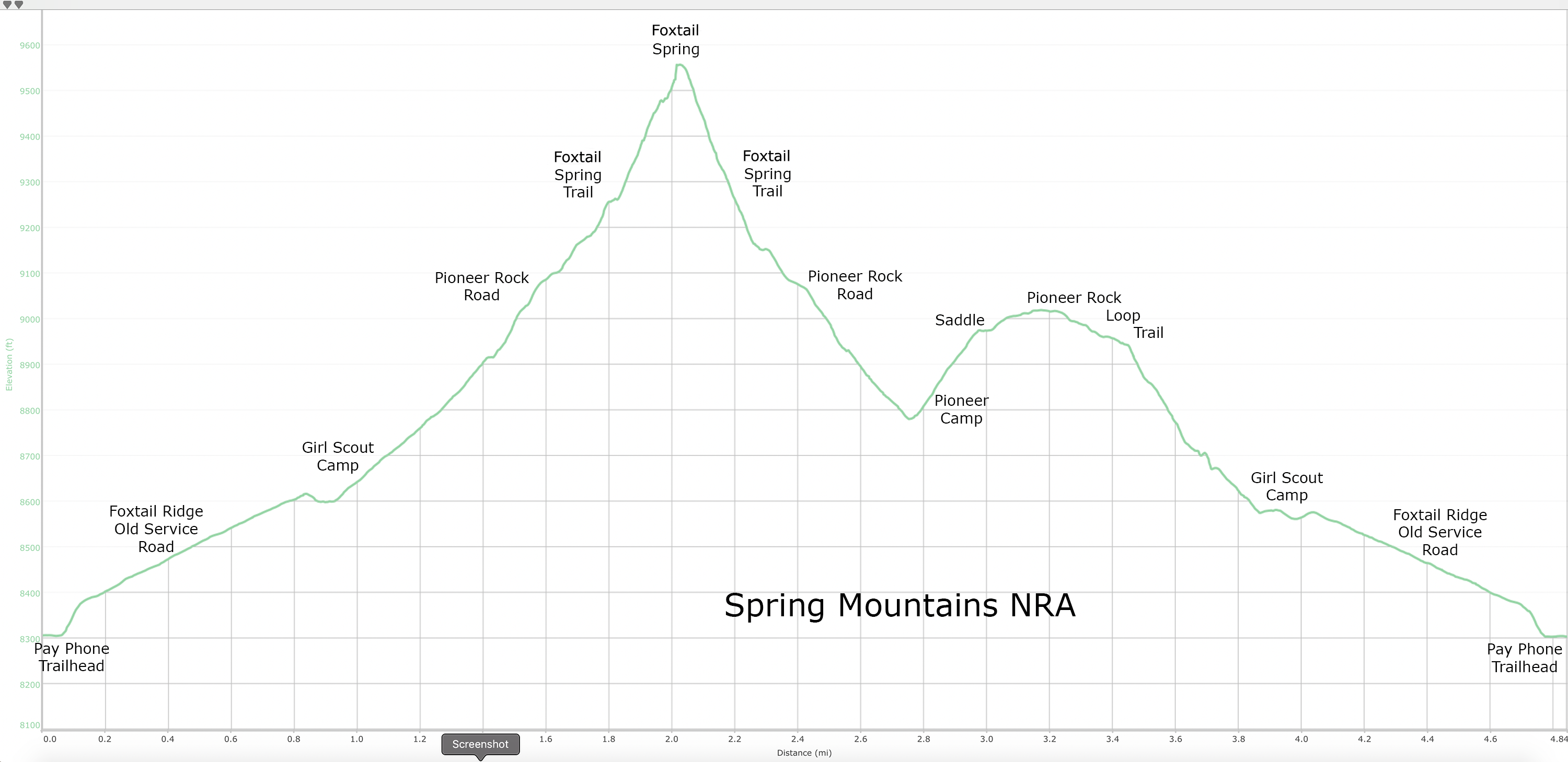
Stats: 4.7 miles; 1480' gain; 3.5 hours
 |
| Lee Peak from Loop Trail |
 |
| Looping back down to Camp Foxtail |
 |
| Gathering at a Felled really Big Tree |