Thursday, June 29, 2023

South Loop 3rd Overlook - 6/29/23

Charleston Peak from South Loop 3rd Overlook

South Loop 3rd Overlook

Climbing the South Loop Trail

Crossing the Griffith Drainage
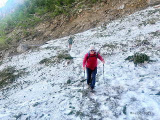
No one that I spoke with could tell me about the snow conditions on the South Loop Trail so the three of us decided to just go up and take a look! We parked at the Cathedral Rock Trailhead and started up. We saw six horses down the hill in the closed Cathedral Rock Picnic Area. This includes one baby. It was so cute! We continued climbing and found that there were several downed trees from this snowy winter we just had. Almost all the trees could be climbed over or gone around but there were a couple that, unfortunately, covered the trail so completely that hikers have made trails around them. (... or, cut switchbacks) There was water running down the Griffith Peak drainage under the snow. 

View down canyon from Echo Overlook
The waterfall in the drainage above was impressive! The fallen trees were crossing the trail all the way up to the 3rd Overlook where we stopped. There were only a few snow patches that must be dealt with on the trail. Nothing serious. However, looking up the trail from the 3rd Overlook, we could see a lot of snow among the trees. In past experience, this is where it is more difficult to avoid the white stuff and spikes might be useful. We took our break at the overlook then headed back down. A wonderful look see back on the South Loop!

Stats: 6 miles; 2100' gain; 3.5 hours

Taking a break at the 3rd Overlook

Taking a Snack at the 3rd Overlook

View up the Trail from the 3rd Overlook


Wednesday, June 28, 2023

Stanley B Saddle Loop - 6/26/23

Griffith Peak from the Stanley B Saddle Area

Climbing the Stanley B Wash

Stanely B Mine

Climbing Stanley B Wash
There were thirteen club hikers on Lettie's loop hike to Stanley B Saddle and ridge. The enthusiasm was palpable! We parked at the large Stanley B Wash turnout found on the right (north) side of Kyle Canyon Road just after the Rainbow community on the left side. The long line of hikers climbed up the hill  and into the wash filled with conglomerate rock and twists and turns. It is a class 2 climb as we stair-stepped up for approximately a quarter mile. On this hike, we turned to the right at the mine road crossing and went up to the shortcut trail on the left. This brought us back to the mine road that had curved around above. Less than a mile from the trailhead, we came to the wash fork where there is an old sign posted on a tree high up.

The Right Fork to the Mine

Climbing up to the Saddle

Stanley B Wash

Lettie, our fearless Leader
After a short rest, we veered up to the right fork and started a climb up a small wash. There was still some water running out of the mine spring above so we had wet feet on the short climb to the mine entrance. The mine is barred and it is assumed that bats still reside within its dark confines. As we waded through the brush and old rusted mining relics, we followed the trail under our feet until the wash opened out a little. From here, it was a constant climb, sometimes steep, up a trail that runs alongside or in the wash. There are a few dry waterfalls that must be dealt with in the way of "2.5" class climbs. Flowers dotted the trail sides and, in a large crack of one of the big fallen trees along the trail, we saw a cluster of big black ants. I wonder if these were Mt. Charleston ants. The group climbed together in a long line with spaces in between. 

Gaylin tackles the Steep Stuff

Mummy's Toe from Stanley B Saddle

Rainbow Canyon from Stanley B Saddle

The small peak above the Saddle
There are only two places you have to be careful to not take a wrong turn. The first one is a fork in sort of a clearing. Take the left fork where there is a trail on up. The second is another fork. A rock outcrop rises above the fork on the right. (This was once our route of choice! But, now, it is very difficult to climb the scree next to the outcrop!) Now, the group took the right fork but kept to the trail that either climbs under or goes around a very large tree that crosses the trail. The trail continues up the wash until brush starts to become a problem. Then the trail goes above the wash on the right side as it becomes more and more vague. Finally, the trail zigzags in and out of the wash up to the official saddle. Today, the hikers followed Lettie up to the right to take their rest at the little ridge peak. Photos were taken, snacks were eaten and conversations ensued! Afterwards, Lettie gave the reigns to Kay (moi) so I could lead the group down to a newly discovered trail in the wash on the opposite side of the mine ridge. I warned them that the trail is messy and probably more so after the winter we have had. They couldn't have been more enthusiastic! So, down we went to accomplish the messy traverse whose trail had all but disappeared. Finally, we reached the last trailing ridge and, lo and behold, the new trail was still there!

Taking a break on the Small Peak

Messy Traverse over to the Next Ridge

Interesting Stuff

Following the Trail down the Ridge
This is the newly discovered trail that someone put in about 2 years ago. A lot of effort went into it and I am hoping that other hikers keep it in use. The group was excited to see the trail appear and we started following it down the ridge. Soon, it turned right to start a long wiggling trail down through small scree. I strongly encourage hikers to stick to the trail as it is laid out. Otherwise, the scree will take over and the trail will quickly disappear, erosion happens. Unfortunately, there is a newly fallen tree that crosses the trail and some branches blocked another section. We are going up there again next week to try to fix these problems. Finally, we wiggled down to the top of the wash below.

Following the Trail down the Scree Hill

Following the Trail from the Upper Wash

Many Waterfalls 

Descending the Wash in the Left Fork
The trail over the debris laying across the wash in this top section was a bit of a mess ... understandably. (What a winter we had!) But, after getting through this small section, the trail was clear ... albeit a bit untidy. Water flowed down this side of the ridge making things a little wet underfoot. The small campsite is destroyed but we didn't have any other difficulties until we reached the little piped waterfall near the bottom. The go-around trail on the left is seriously muddy due to it being a spring. So, we got into the small wash and hiked down the water until a different small trail turned to go around on the right. That worked! At the bottom, just before you reach the last pipe spring at the mine air hole, take a small trail on the left that runs just to the left of the pipe. (Don't take the trail that goes uphill!) This small trail takes you right into the forked area with the mine sign up on the big tree. Happily, we followed Lettie down the mine road around and down to the wash crossing where we came up. We turned left and descended to the cars. Everyone was invigorated with their new exploration. What a fun day with a great group!

Stats: 4.25 miles; 1580' gain; 3.75 hours

Trail being Overgrown

Stanley B Mine Road

Down Stanley B Wash

David's Flower Photos from today's Hike


Sunday, June 25, 2023

Fletcher Peak v Teepee Route O&B - 6/24/23

Fletcher Peak from Teepee side of Hummingbird Gulch

Snow on the Fletcher Peak Trail

Teepee from game trails on Ridge Above

Ascending North Loop Trail
There is a route that we have been trying to pin down for about 2 to 3 years. It is essentially a short cut of a sort around from the lower North Loop Trail to the Fletcher Saddle and on to Fletcher Peak. This route has been used to reach the memorial area where several hikers have had their ashes spread so we kept the route a secret for a while. At this point, many people know about the route. We have tried finding the memorial "tree" but have been unsuccessful. I trust that if you find this tree, you will give it a wide berth and the respect that it deserves as the area holds the ashes of several of our friends. There is, however, a small teepee in the area that was made as a point of reference ... or reverence. The teepee stands on the edge of Hummingbird Gulch and it appears that someone has tidied it up a bit by re-stringing the circular side.

Taking a short Break at the Route Junction

The first Overlook from Tree Blaze

Angel Peak from Overlook

At the Memorial Teepee
Three of us began our hike at the North Loop Trailhead. Climbing up the North Loop to the route junction seemed a little tedious since we only just did the same climb 2 weeks ago. But, as soon as we stepped off the main trail and onto the teepee route, we felt much freer. Although I still don't know the route in detail, we were able to find certain landmarks easily. First, we passed by the tree with the white blaze nailed onto it. Then we hiked down, up and down to the overlook that hangs over the Robbers Roost cliff area. There is a straight line of sight toward Angel Peak from here. Next, still following small game trails here and there, we crossed another gulley and climbed up a shallow wash to the teepee. Just beyond the teepee dropped Hummingbird Gulch. After a few photos, we turned to the right and followed a barely visible game trail paralleling the upper gulch to our left. It was difficult to find the trail sometimes and we left a few very small cairns in case we needed them on our way back.

The Teepee Trail

Climbing the Teepee Trail to the Saddle

Approaching Fletcher Saddle on the Teepee Trail

Snow on the Fletcher Peak Trail (Easily Circumnavigated)
Finally, the vague trail turned into a clearer trail and this led us all the way up to the Fletcher Peak saddle. Here, we saw the first significant snow patch. When we turned to the left on the Fletcher Peak Trail, we had to easily circumnavigate the snow. There were several big snow patches on the trail in this section but all were easily hiked around. Upward, we hiked and, finally, we found the peak to be dry. This being a Saturday, there were several hikers and dogs making their pass-thru. We took a nice break, looked at the scenery, and spoke with other hikers. Conversations summed up this way: Las Vegas is such a great place to live!

Mummy's Toe (R) and Charleston Peak (L) from Fletcher Peak Trail

Hiking up through the Bristlecones

No Snow nearing the Peak

Summit View to the Wet Playa in Three Lakes Valley
After photos, water, snacks and rest, we started down. Around the snow patches passing several other hikers, we reached the saddle and turned to the right onto the Teepee Trail. This part of the trail is easy to follow until you reach a place where the trail seems to fork. The right fork takes you to the route that we had followed up. We took the left fork. This took us on a shorter route that passed the teepee on the ridge above. As we were hiking up onto the main ridge, we spied two small mule deer. I took one photo from very far away and had no idea that I got a good one! (See last photo.) We finally saw the teepee down below then made our way slowly down toward the overlook area. Here, we recognized the trail we hiked in on and hiked back to the route junction on the North Loop Trail.

Wilson Peak from Fletcher Peak

Just the Three of Us 🎶

Griffith Peak from Fletcher Peak Trail

Snow Drift AFTER some snow Melt
Someday, I hope to be able to do this route without checking my GPS so much! The one rock cairns we built turned out to be of no use since we came back on the trail set higher up. Anyway, from there, we hiked down the North Loop to the car. It was a wonderful slow hike among the bristlecones. And, it was our first sighting of deer this season. They are still here!

Stats: 5.6 miles; 1950' gain; 4.75 hours
Returning on the Teepee Trail

Mike on the Teepee Trail

"I taut I saw a Puddy Cat ... Oh, good! ... It's just you!"