 |
| Colorful Harris Peak from Lower Showgirl Trail |
 |
| Oak Leaves in Autumn Color (Tin Can Alley) Transition Zone |
 |
| Grouping of Joshua Trees (Lower Transition/Upper Sonoran Zone) |
 |
| Top of Showgirl Trail (Upper Transition Zone) |
There is a book,
Geologic Tours in the Las Vegas Area, published by the Nevada Bureau of Mines and Geology and written by six administrators of UNLV that go in depth about the life zones represented in the Las Vegas area. Page 37 of this book gives a wonderful graph of the life zones we encounter from the moment we turn onto Kyle Canyon Road from 95 (Lower Sonoran) all the way up to the peak of Charleston (Artic). As hikers, we can encounter large portions of the Upper Sonora and the Transition Zones (also a smidgen of the Canadian Montane Zone in sheltered areas) by hiking the Showgirl Trail from top to bottom. Today, seven hikers did just that on a gorgeous fall day in the Spring Mountains NRA where the fall color 2017 continues to increase and amaze.
 |
| Hiking Showgirl to Hike a Bike Trails |
At around 8000 feet in elevation, the Upper Transition Zone contains ponderosa pines, manzanitas, and live oaks. We also encountered junipers and pinion pines at this level.
 |
| Well Maintained Bike Trails |
This is the type of foliage we entered into after dropping down from the Juniper Trailhead located on Angel Peak Road. (This road turns off of Deer Creek Road near the North Loop Trailhead.)
 |
| Turning onto Trough Trail |
 |
| Passing Water Trough for Wildlife |
We wound our way through the trees with views of Angel Peak on one side and Mummy's Nose on the other. Eventually, we transitioned to the Hike a Bike Trail and came to an intersection with a cross trail. A left turn onto this cross trail put us on the Trough Trail and it was here we began a decided descent. The trough trail is quite steep and requires careful footing on the rocky slopes. There was about 30 yards of steep drop before we came to an intersection. The trail on the right leads back up to the Hike a Bike Trail on a very steep ascent. The trail to the left is a long gentle switchback that bypasses the spring fed water trough. We continued straight down on some more steep stuff to avoid the lengthy switchback and take note of the trough.
 |
| Descent on Gentle Trail |
As we had noted previous to this hike, the trough is occupied by a bees nest and we could see the bees buzzing around the pipe that feeds the trough. After making sure that no one on the hike was allergic to bees, forewarned, we walked past the busy bees without incident.
 |
| Upper Tin Can Alley |
A little further down the Trough Trail, we came to the next intersection. The long switchback enters here on the left. To the right, this trail continues across and down to Telephone Canyon Road on a more gentle slope than the Trough Trail. We turned right.
 |
| Lower Tin Can Alley |
 |
| Bike Trail Bank |
Enjoying the beautiful day, we began seeing a lot of fall color in the trees and bushes along the trail. This trail took its time descending the hill and emptied us at Telephone Canyon Road up from the terminus of the Trough Trail. We crossed the road and hopped onto a trail that ran alongside the dirt road. This could be thought of as the Upper Tin Can Alley. Soon, we passed near the intersection of the Trough Trail terminus and Telephone Canyon Road. We kept straight then turned left onto the real Tin Can Alley Trail to continue down parallel to the dirt road.
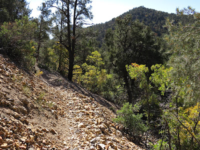 |
| Scree Fall on Middle Showgirl Trail |
At this lower elevation level, the autumn colors abounded! Most of the yellow leaves were oak. We were deep into the middle of the Transition Life Zone.
 |
| Display of Fall Color below Mississippian Monte Cristo Limestone |
Tin Can Alley is so called because of the presence of many rusted tin cans that were leftover from when the telephone lines were being strung by workers many years ago. Bikers have hung these cans on tree branches along the trail.
 |
| Stepladder Peak from Middle Showgirl |
 |
| Photo Op |
The trail has a few banked curves for the bikes then comes to an ... intersection. This junction is marked by two nearby wooden posts. The wooden post on the near side of Telephone Canyon Road marks the beginning of Shady Hollow Trail. The wooden post on the other side of the dirt road marks the middle Showgirl Trail junction. We crossed the road and continued our hike down the Showgirl Trail. This section of the Showgirl is, perhaps the most beautiful. We crossed through a scree section then arrived at a rock cliff section. All along this part, there are views of Stepladder Peak and the bottom of Telephone Canyon.
 |
| View from Middle Showgirl to La Madre Range |
Today's views included a lot of fall color of yellows and golds interspersed among the green trees and shrubs of the scenery.
 |
| Passing Rocky Section |
We looked for a shady spot to sit and have our break but we were almost out of the shade as the sun was overhead at this point. Nevertheless, we found a small spot to sit on the hillside under one of the last trees. We were about half way into the downhill hike.
 |
| Arriving above Angel Canyon |
 |
| Angel Canyon leading to Angel Peak |
After the break, the trail continued to curve around the adjacent ridge. A trail from above crossed our trail and promised to be a popular bike trail descent ... a very fast descent! We followed the middle Showgirl and began a zigzagging route down an intermediary ridge. On the other side of our small ridge was the lower end of Angel Canyon. (This canyon was previously known as AtBF Canyon.) Angel Canyon is a navigable route up to the base of Angel Peak with several interesting scrambles as you go. Finally, our trail dropped down to cross the canyon delta. A small wooden bridge has been built here for bikes.
 |
| Wooden Bridge below Angel Canyon |
We entered into the Lower Transition and Upper Sonoran Life Zones here; very near the Spring Mountains Gateway Visitor Center. Our first views of the fall color on Harris Peak and the continued fall color of nearby brush welcomed us.
 |
| Transitioning into Upper Sonoran Zone |
The aforementioned book reminds us that the life zones tend to meld into each other due to sheltered places and/or more exposed terrains. Therefore, elevation-wise, we were still in the Transition Zone even though the plants were mostly Upper Sonoran.
 |
| Upper Sonoran Life Zone |
 |
| Hiking the Lower Showgirl |
Still, the junipers and pinion pines remained in the landscape. But the joshua trees, creosote and yucca began appearing regularly. The Showgirl Trail was winding in and out among ridges above the Angel Canyon wash and parallel to the Kyle Canyon Road that was off in the distance. As we watched the change of life zone and several very large desert hares hopping away, we reached the Wooden Pole Powerline Road, a very rough dirt road that climbs precariously all the way up to Angel Peak. This road begins at the BLM Fire Station where it intersects with Kyle Canyon Road. We crossed the dirt road and continued through the desert passing several very large and fascinating groupings of joshua trees.
 |
| Fall Color Persists |
This lower portion of the Showgirl Trail was devoid of trees with the exception of low growth berry-filled junipers and, of course, joshuas with a few small pinion pines. We were still seeing manzanitas, as well.
 |
| Grouping of Joshua Trees (Upper Sonoran Zone) |
The trail continues its winding habit through the desert and finally begins a descent along a small ridge. Views over our shoulder were spectacular looking up through the inside of Kyle Canyon.
 |
| Trail crosses the Wooden Pole Powerline Road |
 |
| Posing in front of large Joshua Tree Grouping |
The drop down the ridge put us into a wash with sheltered flora. Last time we were here, we encountered Wimbley, the Mojave Patched-Nose Snake. He didn't greet us this time and we hope he is doing well! Rabbitbrush surrounded the trail as we arrived at the trail tunnel that runs underneath Kyle Canyon Road at the trailhead. Since this is a point to point hike, a car had been positioned here and we used this car to retrieve the others at the Juniper Trailhead eight minutes away. Fantastic day for this hike! Cool with blue skies and autumn colors!
9 miles; 300 feet elevation gain; 2600 feet elevation loss; 3.75 hours at an average of 2.5 mph with breaks and pauses
 |
| View back up Kyle Canyon to Charleston Peak |
 |
| View ahead dropping down Ridge |
 |
| Rabbitbrush welcoming us to Lower Trailhead |


