 |
| Charleston (R) & Lee (L) Peaks from the Bonanza Trail |
 |
| Hiking the Bonanza Trail |
 |
| Ridge Trail heading toward South Sister |
 |
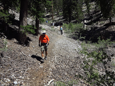
| Starting Up the Old Mill Trail |
Once upon a time, not too long ago, there was a hikers' parking area at the bottom of the Old Mill Picnic Area where the very old pay phone resides. Last month, we were given information that the parking spaces at the phone were still fair game for hikers. Today, we arrived to see ominous looking signs all around these spaces ... but not
in the spaces. So choosing to be quite confused, we parked there anyway and thought about our choice through the whole hike. There was no one around to ask. And, by the way, "
only paying customers get to use the picnic area restrooms." So, feeling a little like "chopped liver," we proceeded up the paved road to the Old Mill Trail, the trail that is lined with rocks and passes by the South Sister Trail junction.
 |
| Weather Station at Bottom of Pine Cone Canyon |
We were already climbing and, soon, nine club hikers junctioned with the Lower Bristlecone Trail. We turned right and came quickly to the Pine Cone Canyon trail junction. We turned right again.
 |
| Geez! So, this is Pine Cone Canyon! |
Pine Cone Canyon is a formidable climb. It is very steep and takes hikers directly up to the ridge of the Spring Mountain Divide ... or the Bonanza Trail.
 |
| Asked to appear tired for the camera, the group gathers at the top of Pine Cone Canyon. |
 |
| Starting Up Bonanza Trail from Pine Cone Junction |
Each hiker had to make this climb on their own terms. Although we had a strong group today, the hikers spread out and gained the ridge one by one. At the top, we rested just a little and took a photo. The hardest work of the day was done. We turned to the right onto the Bonanza Trail and began hiking through one of the most beautiful parts of the trail. There were overlooks, old bristlecone trees, and gorgeous weather. South Sister watched us from our right side and Pahrump Overlook Peak watched from the left.
 |
| Overlook from Bonanza Trail (Pahrump, NV upper left) |
There was one climb on this section of trail that included a few small switchbacks. Views of Charleston Peak from here were very nice and resulted in the first photo of this entry.
 |
| A Few Small Switchbacks |
On the other side of this small peak, we dropped and went back up to our high point of the day (9951 feet). Then after hiking on the Bonanza Trail for approximately 0.75 mile, we arrived at the Ridge Trail junction.
 |
| Setsuko is Dwarfed by Old Bristlecones |
 |
| McFarland Peak from Bonanza Trail |
Two years ago, we began using this ridge trail to go from the Bonanza Trail to the South Sister Saddle. Somewhere along the way, a small rock was placed on the crook of a stumped tree on the left side of the trail here. The small trail turns to the right, climbs over the ridge hump then begins a steep descent. For the first half of the ridge descent, remember to stay to the right when the trail is temporarily lost. (For the second half of the ridge descent, default slightly to the left.) Between the first and second halves of the ridge, there is a great place to sit for a snack break as we did.
 |
| Nearing the Next Junction |
There is a lot of evidence of wild horses living on this ridge. We were not lucky enough to see any wildlife today.
 |
| Descending the Ridge Trail |
After our break, we descended the second half of the Ridge Trail and ended at the South Sister Saddle. We did not need a break here, so when everyone regathered, we began our descent down South Sister Trail to the right.
 |
| A Great Sunday Picnic Spot |
 |
| Approaching South Sister Saddle on the Ridge Trail |
South Sister Trail starts off of the saddle very steeply but eventually enjoys a comfortable descent down through the woods next to a wash. Before you junction with the Old Mill Trail, the terrain flattens out in an area with a spring and an old homestead foundation. The route then joins the Old Mill Trail down to the paved road and continues through the picnic area. We were relieved to find our cars where we put them and with no tickets on the windshield. Further research needs to be done as far as parking allowances go in this area. At any rate, we all had a great hike!
6 miles; 1650 feet elevation gain; 3.5 hours
 |
| Descending South Sister Trail |
 |
| Connecting with the Old Mill Trail Again |
 |
| Paved Road through Old Mill Picnic Area |


No comments:
Post a Comment