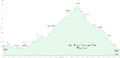
 |
| Northeast End of La Madre Wilderness |
 |
| Trail around End of Cheyenne Ridge |
 |
| Cheyenne Mountain in front of Summerlin Peak (from Buckskin Cliff Shadows Park) |
 |
| Toque Trail |
The weather turned cold again and a total of eleven hikers came out for two different hikes. The more difficult hike was Summerlin Peak but a moderate hike of the Cheyenne Mountain Loop was easier for five of those hikers to swallow. We all started out at the same time from the same trailhead. It was great to see Steve Anderson there to say "hi." The leg is still in a soft cast and he is on crutches but he can't wait to get back on the trails! The loop hikers started north and the peak hikers started west and that was almost the last we saw of each other!
 |
| View up toward Cheyenne Mountain Peak |
We followed the Toque Trail as it winded around the mountain ridge. It is located fairly low on the mountain but never reached all the way down to the surrounding ground.
 |
| Toque Trail heading toward Gilmore Cliff Shadows Park |
BTW, a "toque" is a small woman's hat without a brim. Hmf. Okay.
 |
| Circling the Ridge |
 |
| Trail Sign |
Anyway, the trail on the east side of the mountain has several off shoots for bicycles going up or down. We stayed on the most worn trails when faced with a decision. This nipped us in the ### on the back side when, somehow, we got off route for a large piece of the hike. Nevertheless, we knew how to get back on track when we reached the saddle area. We stopped here for a break and gazed up the route to Summerlin Peak. We searched and searched for our fellow hikers but they were pretty far away. It wasn't until a photo was studied at home that we finally found our only picture of one of the hikers that was standing on this side of the peak. The others were probably beyond view the whole time on the other side of the final ascent.
 |
| The only view we saw of our AtBF Summerlin Peak Hikers! |
After the hike, Mike OC sent us the summit photo from the peak hike. He reported that all made it down safely without bloodshed!
 |
| Hiking toward the Saddle |
After our break, we continued around the mountain ridge. The views on this side of Cheyenne Mountain are really beautiful. They are of the northern end of the La Madre Wilderness.
 |
| Nearing the Saddle off Route |
 |
| Snack Break at Saddle |
As we were hiking this portion of the loop, four or five runners came sweating by in a group. Nice looking bunch of young men ... well, I digress. Anyway, we reached the other end of the ridge and looked up to see the cave. Once a home to someone; now, a home to cairns. We finished our loop and dropped back down to the trailhead and the cars. This is a nice 4.5 mile loop without a lot of elevation gain. Good for a morning hike with pleasant company.
4.5 miles; 700 feet elevation gain; 2.5 hours
 |
| Beautiful View North |
 |
| Las Vegas Skyline from South end of Cheyenne Ridge |
 |
| The Cave Above |


No comments:
Post a Comment