Friday, April 15, 2022

Hoodoo (Spire) Forest Loop (Desert NWR) - 4/14/22

Above Hoodoo Forest

Standing Rock

Descent Ridge

Cow Camp Road - Black Hills Pass

A hoodoo (also called a tent rock, fairy chimney, or earth pyramid) is a tall, thin spire of rock that protrudes from the bottom of an arid drainage basin or badland. Hoodoos typically consist of relatively soft rock topped by harder, less easily eroded stone that protects each column from the elements. They generally form within sedimentary rock and volcanic rock formations. Hoodoos range in size from the height of an average human to heights exceeding a 10-story building. Hoodoo shapes are affected by the erosional patterns of alternating hard and softer rock layers. Minerals deposited within different rock types cause hoodoos to have different colors throughout their height.

Leaving the Trailhead

Approach to Hoodoo Canyon

Window Hoodoo


Starting into the Narrows
In certain regions of western North America these rocky structures are called hoodoos. The name is derived from  Hoodoo spirituality where certain natural forms are said to possess certain powers, but by the late 19th century, this spirituality became associated with bad luck. Prior to the English name for these geographic formations they were already the origin of many legends from Native Americans such as Bryce Canyon National Park where hoodoos were considered petrified remains of ancient beings who had been sanctioned for misbehavior. Hoodoos are found mainly in the desert in dry, hot areas. In common usage, the difference between hoodoos and pinnacles (or spires) is that hoodoos have a variable thickness often described as having a "totem pole-shaped body". A spire, however, has a smoother profile or uniform thickness that tapers from the ground upward.

    Hoodoos typically form in areas where a thick layer of a relatively soft rock, such as mudstone, poorly cemented sandstone, or tuff (consolidated volcanic ash), is covered by a thin layer of hard rock, such as well-cemented sandstone, limestone, or basalt.

Small Scramble Up

Hoodoo Canyon

Color in Hoodoo Canyon

     
In glaciated mountainous valleys the soft eroded material may be glacial till with the protective capstones being large boulders in the till. Over time, cracks in the resistant layer allow the much softer rock beneath to be eroded and washed away. Hoodoos form where a small cap of the resistant layer remains, and protects a cone of the underlying softer layer from erosion. The heavy cap pressing downward gives the pedestal of the hoodoo its strength to resist erosion. With time, erosion of the soft layer causes the cap to be undercut, eventually falling off, and the remaining cone is then quickly eroded.
     Typically, hoodoos form from multiple weathering processes that continuously work together in eroding the edges of a rock formation known as a fin. For example, the primary weathering force at Bryce Canyon is frost wedging. The hoodoos at Bryce Canyon experience more than 200 freeze-thaw cycles each year. In the winter, melting snow, in the form of water, seeps into the cracks and then freezes at night. When water freezes, it expands by almost 10%, prying open the cracks bit by bit, making them even wider, similar to the way a pothole forms in a paved road.

Approach to Breaching Whale Hoodoo

Slippery Climb at Base of Breaching Whale Hoodoo

Fit Five at the Breaching Whale

Mike climbs up to the Ridge Above
In addition to frost wedging, rain is another weathering process causing erosion. In most places today, rainwater is slightly acidic, which lets the weak carbonic acid slowly dissolve limestone grain by grain. It is this process that rounds the edges of hoodoos and gives them their lumpy and bulging profiles. Where internal mudstone and siltstone layers interrupt the limestone, one may expect the rock to be more resistant to the chemical weathering because of the comparative lack of limestone. Many of the more durable hoodoos are capped with a special kind of magnesium-rich limestone called dolomite. Dolomite, being fortified by the mineral magnesium, dissolves at a much slower rate, and consequently protects the weaker limestone underneath it. Rain is also the chief source of erosion (removing the debris). In the summer, monsoon-type rainstorms travel through the Bryce Canyon region bringing short-duration high-intensity rain.

~Wikipedia
Desert National Wildlife Refuge - Sheep Mountain Range

Weathered Tree at Hike High Point

Communication Gap (Snail & Turtle)

Ralyn enjoys her new Hike
On a cool April day, the Fit Five hikers rode out to Wagon Wheel Trailhead at the end of Cow Camp Road in DNWR. As we were tooling through Black Hills Pass, we noticed that there were two large pipes sticking from the ground that did not have the protective large rocks on top of their openings. We stopped and fixed that. The road seemed to be in the best shape it has been in many years. A careful high clearance SUV could probably make the trip.
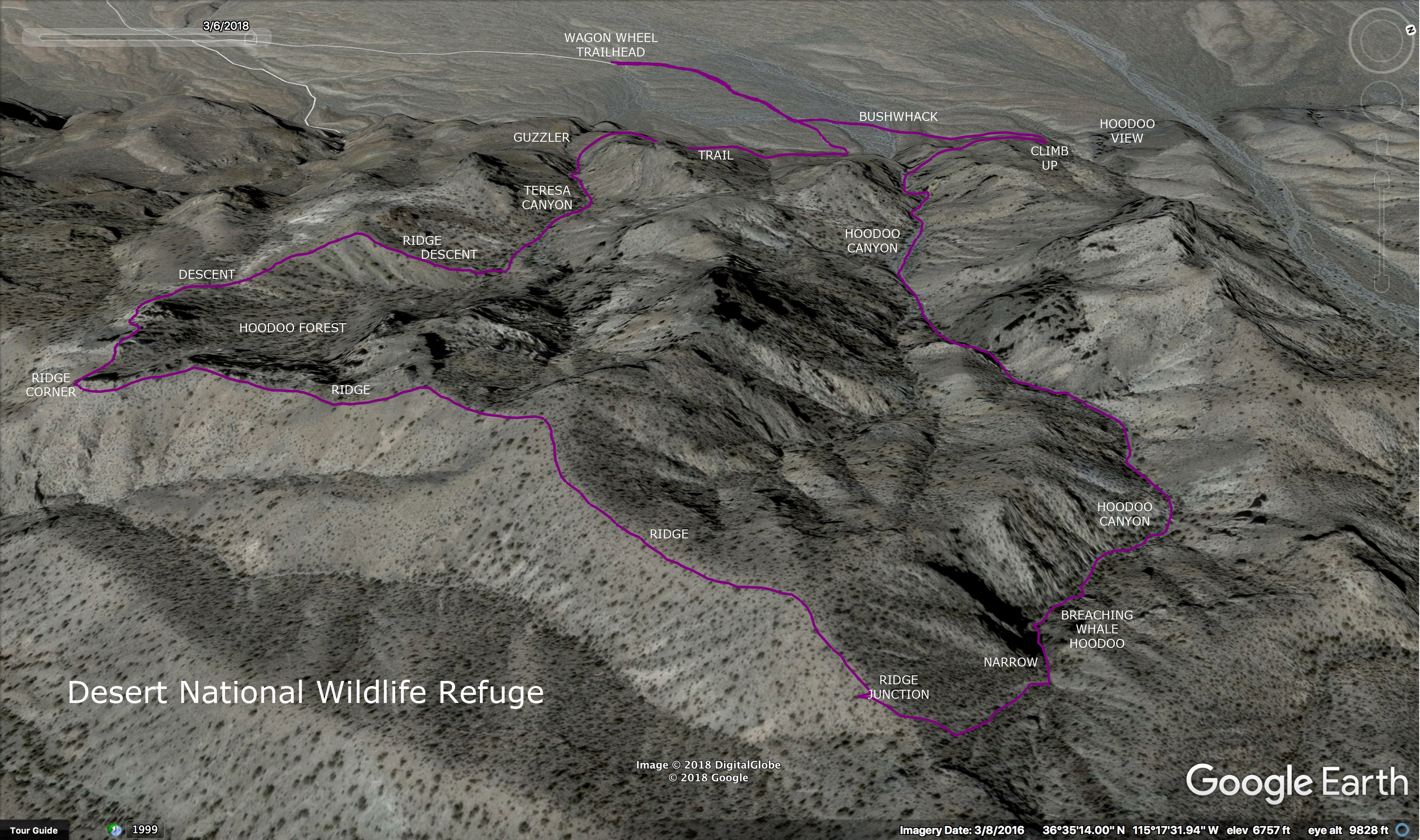
   We left the trailhead heading northeast to find Wagon Canyon's opening. Here, we got a nice view of the Hoodoo Overlook. The hoodoos on this hike are more like pinnacles and they are quite fat! We climbed up to the shelf on the right and crossed over to the next canyon to the right, Hoodoo Canyon. The pourover here and the one we see at the bottom of Teresa Canyon later, are used for learning rappelling and other rock climbing activities. We turned to begin ascending gravel in Hoodoo Canyon by passing the Window Hoodoo. Right away, the canyon was filled with hoodoos on the ridgelines. The canyon became more narrow as we climbed and more hoodoos appeared lower down. Soon, we were climbing bigger rocks and passing hoodoos at our level.

Hoodoo Ridge above Teresa Canyon

Hoodoos below Hoodoo Ridge

Desert Colors

Rising higher than the other hoodoos was the Breaching Whale Hoodoo. This anomaly marked the narrows of the wash, a slippery steep climb up a pourover. After that, the route veered to the right onto the ridge where we climbed steeply to the main ridge above. Once there, we turned right to reach the hike high point and continue around the ridge that runs above Teresa Canyon, Hoodoo Ridge. From this height, we could look down on Hoodoo Forest. There are dozens of pinnacle hoodoos puncturing the air below the ridge. We continued around the ridge admiring the views. At first, we thought that the black Standing Rock formation had fallen down and we were giving it an elaborate memorial eulogy as we hiked. But, wait! There it is! You just can't see it until you get to the other side of Teresa Canyon. It is quite the spectacle.

Large Hoodoos

Picture Canyon at Left - Large Hoodoos to Right

Large Hoodoos on Descent Ridge

Jerry & Cheryl Descend from Break Point
We took our break before we began our descent on the ridge to the south of Teresa Canyon. There is another ridge forking down from our position as well. This ridge runs above a wide canyon that flows into Picture Canyon right at the junction that contains a very large ancient agave roasting pit. See the second photo above this. After the break, we dropped down on the descent ridge and weaved our hike through very large fat hoodoos. We noticed that there has been a recent landslide inside Teresa Canyon. It appears that a hoodoo split and caused rocks to slide down about 100 feet. Maybe that was the result of "frost wedging" as described by Wikipedia above. 

Within the Large Hoodoos

Pointy Hoodoo

Recent Landslide below Standing Rock and Communication Gap

Hoodoo Forest at Top of Teresa Canyon
The descent continued down the ridge to a saddle where a trailing ridge to the right connects. The trailing ridge is the most gradual descent into the canyon that is offered. In the canyon wash, we had just a few gentle scrambles to contend with then we turned to the right onto a vague trail above the pourover at the end. The trail led us over to the vicinity of the Hoodoo Canyon pourover where there is a gentle scramble down to the desert floor. All that remained was a hiked down the abandoned dirt road that runs from there to the trailhead. What a beautiful day with great company!

Stats: 4.7 miles; 1670' gain; 4 hours


Descending Teresa Canyon

Last Big Scramble

Return to Trailhead


No comments: