Thursday, July 12, 2012

Fletcher Peak to Fletcher Canyon - 7/12/12

                Cockscomb Peak from descent into Upper Fletcher Canyon.

                       Butterflies resembling the Common Leopard Butterfly.

Nine nifty hikers dove into the world of the unknown today. The scheduled hike of the traditional Fletcher Peak morphed into an exploratory hike that took the hiker from the top of the peak to the bottom of Fletcher Canyon on a route that was anything but traditional. It was a point to point hike that ended up being 8.25 miles with 1800 feet in elevation gain and 3300 feet in elevation loss.

After placing one car at the Fletcher Canyon trailhead, we drove up to the North Loop trailhead and began our climb. The jack rabbits made short work of the climb to the meadow but slowed down to wait for everyone else through the switchbacks. We regrouped again at the North Loop high point then began the descent to the Fletcher Peak trail junction ... then the Fletcher Saddle.

                 Hiking down to the Fletcher Saddle from the North Loop Trail.

                                Hiking from the Saddle toward Fletcher Peak.

 Leaving two of the nine hikers at the saddle, the remaining seven hikers challenged themselves to climb Fletcher Peak, take a break, sign the log book then return to the saddle.

Clouds were hanging low but they were not menacing at any point during the hike. The weather was almost cool which was quite a difference from recent hikes in the sun. Temperatures in the valley have been reaching over 110 degrees for the last five days.

 The photo to the right above shows the final climb to the peak. To the right below is a photo from the peak looking out toward the Las Vegas valley. It would be very nice to get a little rain in our corner of the desert. This year has been very dry.

                                     Fletcher Peak Summit

                Hiking back to Fletcher Saddle with Mummy's Toe in background.

 On our return to the saddle, the two hikers who had waited for the summiters were ready to go. We dove down a small trail that led off the saddle into the Fletcher Canyon bowl. We had been warned that the steepness and presence of cliffs in this area were probable. We eyed the first major wash that we passed and immediately knew that the warning was warranted. We continued on the small trail that parallelled the North Loop Trail above and decided that it must be a game trail.

 We circled around the top of the bowl searching for that magic wash to descend into. Choosing a promising yet scree filled wash, we began losing elevation quite rapidly. We negotiated several scree covered hillsides and found the game trail again! Finally, we got cliffed out. However, Fletcher Canyon, the last possible wash we could use, could be seen below. Going up a short ways and dropping down another steep scree filled slope, we arrived, where else but, the first waterfall landmark where the ponderosa pine towers above. With one collective sigh of relief, nine hikers dropped into the canyon and started down the trail.

                             Second Upper Fletcher Canyon landmark.

                             Fletcher Canyon just above Obstacle Rock.

 We were still one mile above Obstacle Rock so we carefully made our way down the trail that was covered with fallen trees and grown up brush. The stream was dry for the most part so the beauty of the canyon was not apparent. Most of us were pretty exhausted by then as the going had been tough yet very exciting.

 Obstacle Rock was a welcome sight and we went about the business of lowering our packs on the left side of the rock and lowering ourselves through the "rabbit hole" on the right side of the rock. Finally, with everyone down from the rock, we took a much needed second break. We all knew that there were still two miles remaining.

                                Taking a break at the bottom of Obstacle Rock.

 The nine hikers chose their own pace to finish out the hike through the lower part of Fletcher Canyon. The rough angelica was in full bloom and even the butterflies seemed to be celebrating our arrival. Slowly, the two miles were put behind us and everyone agreed that the exploration was very enjoyable and adventuresome. After we collected the cars and started down Kyle Canyon road, we saw black clouds in our rear view mirrors.

                                Hiking out of Fletcher Canyon.


Tuesday, July 10, 2012

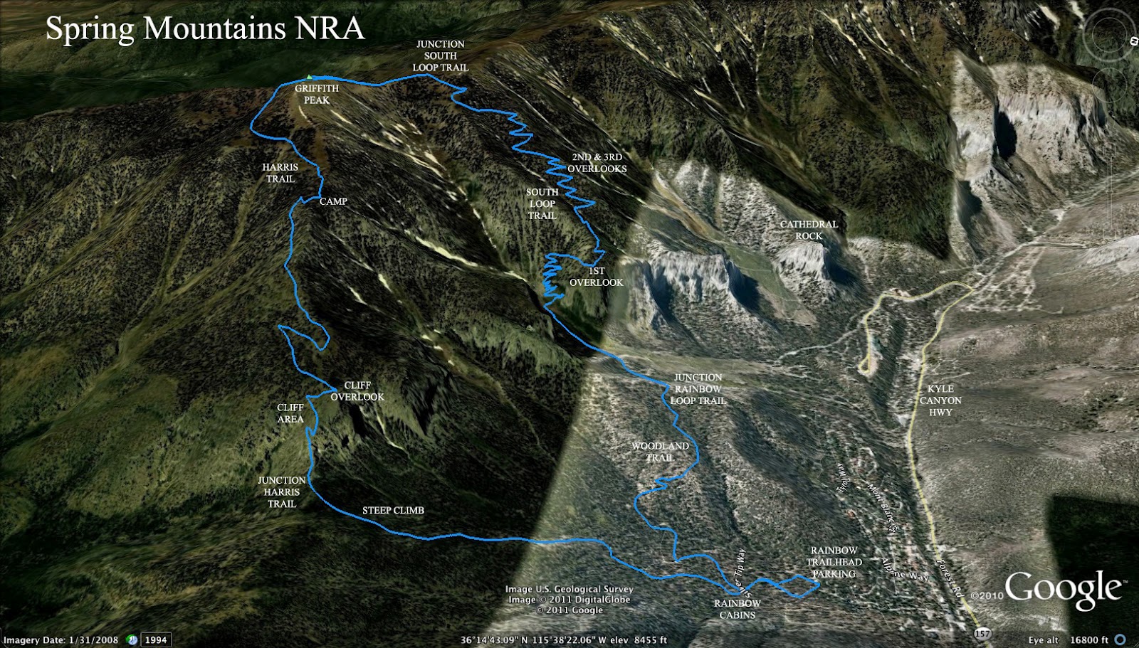
Griffith Peak via Rainbow - 7/10/12

                     Marble, the dog, joins AtBF on their Super Tuesday Hike.

Mike OC reports in for today's hike with these words, "Six guys and Marble." Marble lives somewhere in the Rainbow area and has joined the club on hikes before as they climbed up through the residential neighborhood.

She was there to greet us as we arrived at the trailhead--Marble Irene Kent, AKA Marble the Wonder Dog.  She stayed with us for the entire five hours.  She scampered up the precipitous Harris Peak Trail, blazed the trail up to Griffith Peak and completed the loop by leading us back down the South Loop Trail to our cars.  We pet her, nourished her and slaked her thirst.  She never whined; she never barked.  Marble literally ran circles around us the entire day.  She chased any creature that moved.  We labored; she frolicked.  We did 10.5 miles; she did 25.  She was our daylong companion.  We were six men and a dog.

This particular hike climbs up through Rainbow to the ridge between Griffith and Harris Peaks. Here, a right turn onto the Harris Springs Trail is taken. The hike proceeds up through the "cliff area" and circles around Griffith Peak with views of Lovell Canyon. After climbing the peak on the regular approach trail, hikers descend using the South Loop Trail and crossing over to Rainbow using the Rainbow Loop Trail. It is a ten mile loop hike with 3500 feet of elevation gain.


Sunday, July 8, 2012

Hummingbird Gulch / Fletcher Peak Loop - 7/8/12

                                           Hummingbird Gulch

                                Window seen from Hummingbird Gulch

 Seven hikers went up to the Spring Mountain NRA's Deer Creek Highway for a Sunday stroll this morning. The relaxed hike began and ended at the Hummingbird Gulch parking located on the left as you drive up toward Robber's Roost. The hike would have a 2600 elevation foot climb and descent over the course of 6.5 miles. Did I say "relaxed?" Well, it was certainly a tough hike, however, the pace was not pushed on this very warm day.

 There is a fairly clear trail leading up through the rocky gulch but at times, it was very steep and covered with loose limestone scree. It was only a little brushy and, at one point, there was a small amount of water running from a nearby spring. After the water, we climbed out to an overlook area where we saw the scene pictured below. At the overlook, there is a shelter built with limbs.

                                Overlook approximately half way up gulch.

 Climbing past the overlook area, we came to what is known as the "split rock" as seen to the right. The trail continued up through the forest as we passed by a dry skeleton of a horse's head. We took several breaks in the heat. But, the small trail continued to wind up and around and around and up until the Fletcher saddle came into sight.

 At the saddle, three hikers decided to take their break there while the remaining four hikers continued the climb to Fletcher Peak. While resting, a small exploration was made down the canyon on the other side of the saddle. Someday, we would like to take this new trail down to Fletcher Canyon but, today, the decision had already been made to change the planned hike to a loop down the North Loop Trail.

                View of Mt. Charleston and Mummy's Toe from Fletcher Saddle.

 After a prolonged break, the three hikers decided to climb up to the North Loop Trail and wait for the other four hikers at the North Loop high point. On the way, both groups of hikers met up with another group of Around the Bend Friends who had decided to climb Fletcher Peak the regular way using the North Loop. At any rate, we regrouped at the high point and began our descent.

 Quickly, the group spread out as old injuries took their toll. Halfway down to the meadow, the leaders called back through the switchbacks and offered to reach the cars at the gulch parking ahead of the last person in line and drive up to meet that person at the North Loop Trailhead. (Don't mind if I do!) And, off they went.

                          Mummy's Toe as seen from Fletcher Peak trail.

 The six hikers put a lot of space between them and the last hiker as they continued through the meadow and down. At the trailhead, they hung a right DOWN on a maze of bike paths which were filled with bike jumps and banked curves. It was reported that the bike trails were steep and very slippery.

 One mile downhill and the six hikers reached the gulch parking while the last hiker made her way down the road where she could see the bright red truck pull out in the distance. The offered ride was much appreciated when it arrived and the Sunday stroll was in the history books.

                                       North Loop Bristlecones.

                                          Lower North Loop Trail.


                                   Elevation graph for hike point to point.

                                 Elevation graph for loop hike.


Friday, July 6, 2012

Eight Ducklings - 7/6/12


Hey club members! Announcing eight little ducklings at the Painted Desert Golf Course Hole #14. These little guys just made their appearance today and we think this was their very first swim. Really. Does it ever get any more adorable than this?