Tuesday, November 17, 2020

Hidden Peak & Permanent Change in Route at Mountain Springs - 11/16/20

Map showing Permanent Change in Route between Agave Roasting Pits and Trailhead
Yellow Line = New Route

A shout out to the man who owns the 40 acres that we have been hiking through for years. Thank you from all of us for allowing our hikes to hike through! We understand your need to fence in your property in these crazy times. I hope you get this message. (P.S. We miss the miniature horses!)

BTW, the construction on SR-160 is completed up to the Trailhead! Yea!!!

Archive Photo of Hidden Peak from Overlook

Archive Photo of Escarpment View from Approach Trail

Ralyn and Rita on Hidden Peak

Rita, Kay and Ralyn on Overlook
Our fearsome foursome of AtBF hikers did the 9 mile loop to Hidden Peak today. It was a beautiful day! Hidden Peak was very popular today as we met up with five other hikers, 3 females and two canines. I managed to cross the scary bridge between the overlook and the peak today. Maybe next time I'll actually get to the peak! But, honestly, the view at the overlook is unbelievably fantastic and I am always quite satisfied to stay there and wait. While I waited, Rita, Ralyn and Mike climbed to the peak and said the same things about the views from there. For a more detailed blog on this hike go to http://aroundthebendfriends2.blogspot.com/search?q=Hidden+Peak   We had a great day and finished our hike by using the Burnt Ridge descent.

Stats: 9 miles; ~2300' gain; 5.5 hours

Black Velvet Canyon and Peak from Approach Trail

Returning with view of the Escarpment Arch

Descent along Mountain Springs Peak Trail


Friday, November 13, 2020

Terrace Canyon - 11/12/20


Terrace Canyon to Bridge Mountain

Hiking & Scrambling between the Walls

First Pool

Hiking through Pine Creek Canyon
It had been a few years since I hiked and scrambled into Terrace Canyon and up to the terraces. Today was a great opportunity to go with our small AtBF pod, follow the best Terrace Canyon leader, Mike, and slowly make our way up through each considerable scramble with care and attention by everyone involved. Not only were those stars aligned but it was also a gorgeous day with lingering fall colors, plus there wasn't an over abundance of water pooled up in the canyons to create impossible obstacles. 👍We reached the Pine Creek Trailhead off of the Scenic Loop of Red Rock Canyon NCA around 7:45am. All the trailheads along the loop were near to empty until we reached Pine Creek! There, it was filling up fast with rock climbers!

A Visit at the Wilson Homestead

The 6.5 to 7 mile hike begins by dropping down into Pine Creek Canyon. Follow the main trail down past the old Wilson Homestead to the junction triangle and veer to the left.

Starting up the South Fork of Pine Creek Canyon

This trail will take you through some brush and winds down into the South Fork of Pine Creek wash. There is a lot of beautiful color here.

Mike washes his Hiking Stick at First Pool

Blue Pool
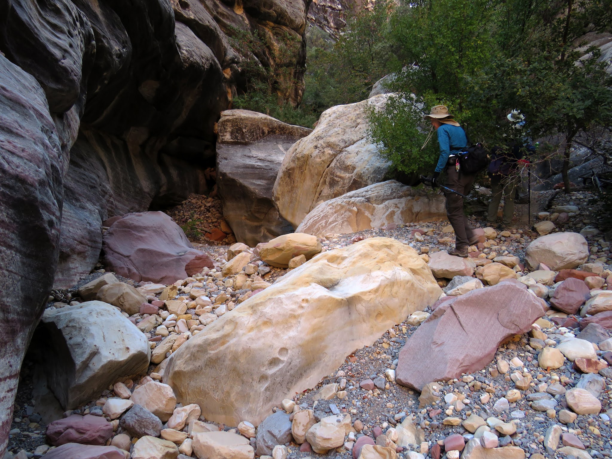
We took a trail up the hill toward the base of the front of Mescalito Peak (Little Redhead). This trail winds along entering the South Fork and will drop you into the wash at different points. It is best to go up as far as you can before you head into the wash. There is somewhat of a trail throughout the wash hike and scramble. Always look for it anyway! There also may be a few cairns ... if you look for them. But, do remember that there are many obstacles providing a multitude of opportunities for serious class 2 to 3 scrambling. (Hey! If I can do it ....) Many of the obstacles are not intuitive. It is always best to be shown the ropes (so to speak) by someone who knows the drill. ... Like Mike! He was very impressive in his knowledge of the route and scrambles.

In the Canyons

Although I find it very difficult to see the canyon forks for the trees, there is a good rule of thumb for the "directions." Starting with the left turn into the South Fork of Pine Creek Canyon, there are three left turns and one right turn. Good luck with that!

Boulder Hopping

As an aside, there were two fun rock climbing dudes that were following us in the beginning looking for "a brown rock with scratches on it." Hmm. Yep. They were in the wrong canyon; looking for Juniper Canyon. Of course! 😐

Striking Sandstone Colors

View Down Canyon
Some of the more interesting scrambles start with a climb up next to a tree root on the right side of the canyon. Another that was impossible for me without a lot of help was also on the right side of the canyon where I had to brace myself with my feet on one wall while scooting up onto the steeply slanted rock behind me. There were many times when you were required to leap from the top of one rock to the top of another. Then there were several times you have to take the step of faith on a steeply slanted rock hoping that your shoe soles were all the manufacturers said they were! One large boulder had to be climbed as you prayed! See the photos to the left and below. There were certain obstacles that you will never forget and this is one of them!

Up, we go!

Moving on, we passed the remains of a dead baby deer. It was very sad and we didn't want to talk about it. But, it looked like he had fallen about ten feet from the boulder above.

Tunnel of Wonder

There was also the spine remaining from another animal. See the pic six photos above. It may have been either a deer or a small bighorn. Circle of life. 😞

Hiking up Walls

Entering Terrace Canyon
One obstacle can be avoided by a walk around on the left side of the canyon as I did. But, I remember the obstacle as one that I was previously able to lift my ballerina leg up onto the rock sideways and scoot over until I was sitting on the huge boulder. (I might be able to still do it!) One of the final really challenging obstacles cannot be avoided but it could be accomplished by either sitting or crawling. Nevertheless, we were all able to sidle by a large boulder while standing on about 6 to 8 inches of free space below. See photos of this obstacle in the collage six photos below. It is my nemesis but we all managed with flying colors! (Luckily, we didn't have to actually fly!) 

Terrace Canyon

The final left canyon fork turn was marked with a huge cairn for a long time. But, we could tell that the canyon geology has been somewhat rearranged due to flooding and the huge cairn was gone.

Pool among the Terraces

When we arrived for the "huge" cairn, it was simply two rocks! We fixed that by adding another five rocks! It should be built up a lot more so, if you pass by, add a rock or two to the stack.

View down the Terraces

Climbing the Terraces
At last, we arrived at the bottom of Terrace Canyon proper! We had seen a couple of iced-over puddles before but there were a few small snow patches on the terraces. No water was running down the terraces that we could notice but there were a few pools. I took several photos on my way up to the top behind the others. I reached a snow covered rock that someone had written on, "Mike's Canyon." I thought it was our Mike until he set me straight during break. It wasn't him ... just kismet! We enjoyed our break with an incredible view then took our group photo when we started down. (Ask Rita about the strange bug she sat next to!) No bighorn (alive) sightings all day. Only Bridge Mountain and the Mescalito Ridge could be seen rising above the down canyon view.

Fearsome Foursome

Mike pointed out the junctions for Juniper Peak and Gunsight Notch Peak. They are found in the last left fork canyon on the left side.

Enjoying the Challenge

During this section, be careful to stay connected to the canyon wall on the right so that you do not head up into the wrong canyon and end up on Gunsight Notch or Juniper Peaks! Hmm.

Starting Down

Sit and Slide
As we methodically headed down canyon, we were tiring. It was important to keep our concentration. Most of the huge obstacles could be negotiated easily by sitting and sliding. ... Or, by simply walking down the rocks with those shoe soles! Although speed was not an issue today, we managed to end up with pretty good time; maybe because of the small group. Back across my nemesis. Back through the small sandy rock fall area. Back down the steep rock. Back down the impossible climbs that were now easy descents. The tree root descent turned out to be one of the more difficult descents! Finally, we saw a couple of human beings and a canine! And, finally, we entered into the South Fork wash. Our next turn would be the left trail out of the wash.

A Veritable Freeway

We found a well worn trail climbing the hill below the base of Mescalito and followed it over the hill to drop back into the wash. This section of the wash is very colorful! See four photos below.

What goes up must come down!

Finding the trail to take us back to the main Pine Creek Trail was, perhaps, the most difficult navigation of the day! Found it!!

Rita expertly demonstrates a difficult spot!

Back at the Base of Mescalito Peak
Back on the main Pine Creek Canyon Trail, we passed several recreational hikers. Everyone had a mask so I lifted my buff up over my nose. There were rock climbers on the walls in different locations. But, we only knew that because we could hear them! We quickly hiked back past the Wilson home then up that long hill to the cars. Long day but we were all very happy with our beautiful hike. We'll be sore! A shout out to Ralyn! This was her first Terrace Canyon endeavor! She is a great scrambler as is Rita and Mike. Me? Eh. 😳😅

Stats: 6.8 miles; 1350' gain; 6.5 hours

Beautiful Wash below Mescalito

Hiking Out as Sun gets low on Horizon

Climbing the Hill below the Trailhead


Tuesday, November 10, 2020

Blue Diamond Sidewinder - 11/9/20

The Sandstone Bluffs with Fall Color near Blue Diamond

Cuteness

Fall Color at Wheeler Camp

Connecting with Landmine Loop
It was ladies' day at Red Rock Canyon NCA for our small AtBF pod. We found that the warmest locale for a beautiful hike would be the hills behind Blue Diamond. We parked our cars at the Wheeler Camp/Springs Trailhead on SR-159 between the old Oliver Ranch and the entrance to Blue Diamond and started out across the wash and up the hill in front of us. (Reminder: Always close the gates behind you to preserve the bird sanctuary from the hungry burros!) This trail will connect to the Landmine Loop. Here, you must keep an eye out for bikers. They love this trail and, even though we have found that the bikers are usually very courteous, we tend to surprise each other! The Landmine Loop circles around through the old Oliver Ranch junk dump that includes an old car lying on its side at the base of a hill.

Following Landmine Loop

The car, again, has graffiti scratched into it. Kids! So far, no burros. But we knew they were there. (Ahem!) Anyway, we hiked along a fence before we made our next turn.

Junctioning with Sidewinder Trail

At the red dirt, we turned left onto a trail that headed into a canyon in the side of the hills. The trail crossed over to start a climb up the right side of the hills.

Watchful Eyes Above

Sidewinder Trail Ascent
Still no burros. Another left turn near the top of the initial climb put us on the Sidewinder Trail. As we began putting in our dues on the climb, Ralyn and Rita spotted burro ears above. We were under the watchful eyes of a mother burro and her baby. She moved on then we moved on. We circled around until we could see that same red dirt canyon far below. The same burros sheltered at the bottom. The trail began its sidewinding and we saw the next red dirt canyon. Near the bottom, we saw a large group of burros (mostly gray) starting to climb the hill. They saw us and detoured their route.

Sidewinder Trail

We watched as the group made their way up the side of the hill leaving a mother and beautiful light colored baby at the back of the group. She hugged her baby then decided to follow the group.

We counted thirteen in all!

It was a steep route that they had chosen so the baby was a little slow. Mother made sure her charge was making it okay. Finally, we moved on at our non-dawdling pace.

Ladies Day

View from cliffs at Blue Diamond Cactus Garden
We followed the trail climbing up and into the Blue Diamond Cactus Garden; aka The Crags. Needing the warmth of the sun, we hiked through to the cliffs on the other side for our break. What a bee-utiful day!! There was slight snow dusting on a few of the escarpment peaks but it was quickly melting. The most impressive display of snow was on Griffith Peak. It was completely white but we couldn't see much of it from our vantage point. Mt. Potosi was, perhaps the most dusted in our area. We were dressed for the cold and there was very little wind so we were quite comfortable.

Blue Diamond Cactus Garden

Next, we dropped down the other side of the garden and connected with the Hurl Backdoor Trail that runs along the tertiary ridge all the way over to the main trails behind Blue Diamond. A left turn onto the main Hurl Trail took us past the large sandstone outcrop where we sometimes take our break for a different hike.

Break at Cactus Garden

 Then, we hiked around the ridge above a canyon on our right and started dropping down. This canyon has a trail on the right side and a trail on the left side. We chose the left side then found a very faint trail turning to the left just before we crossed the wash at the bottom.

Hurl Backdoor Trail

Descent from Ridge
 This sidewinder trail is rarely used and we were surprised to come across another hiker. He told us that his name was Larry, lived in Blue Diamond, and had made this vague trail out of an old burro trail. We thanked him and promised we wouldn't be too explicit about its whereabouts. Although ... just sayin' ... it is a great route to hike from one side of Blue Diamond to the other without having to go through the small town of Blue Diamond where they seem to frown on visitors. It seems like they would want this trail to become known. That said, it is definitely not a good route for bicycles. Hikers only. Another fun burro day! They look so cute from afar! (Be kind to Blue Diamond! They only want decent hikers and bikers in their vulnerable backyard!)

Stats: 7 miles; 1150' gain; 3.75 hours

View from Ridge

Passing above Blue Diamond

Using Burro Sidewinder Trail for Return