 |
| Catch Pen & Spring |
 |
| Through the Arch |
 |
| Mummy Mountain from near beginning of Ascent |
 |
| Odie gets down to business. |
It was an Odie day on the trail! Ralyn, Odie and I started from the Orange Trail Trailhead located on Deer Creek Road between Desert View Overlook and Deer Creek Picnic Area to hike the 8.5 mile equestrian loop into the lower elevations. Odie was ready! We immediately turned to the right and followed the pleasant trail around to a nearby ridge that would take us all the way down to the catch pen and spring. The cool morning kept our speed up as we gently headed downhill. Odie sprung into action and didn't dilly dally. He's a very good hiker. Don't let his size fool you! At the low limestone/ dolomite arch, we stopped for our first break and photos. Continuing down the hill, we could see the scene of the Mahogany Fire of 2020. The regrowth of the underbrush is green and the ashy color has dissipated. We also noted a new building has been built in the saddle of Angel Peak. This is where the Spring Mountain Youth Camp is located.
SMYC is a juvenile facility, which houses male youth between the ages of 12 and 18 who have been adjudicated for delinquent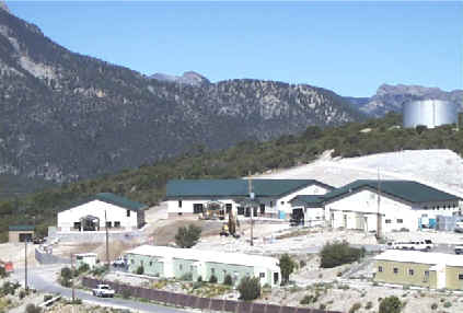 acts by the Juvenile Court Judge. This division provides for the therapeutic, educational, social, medical and recreational needs of approximately 240 young men each year. SMYC is located at Angels Peak in the Mt. Charleston Recreational/Toiyabe National Forest Area. It sits at an elevation of 8,470 feet and has a capacity of 100 youth. The average length of stay is approximately six months and the average age is 15 1/2 years. ~clarkcountynv.gov
Stats: 8.3 miles; 1800' gain; 4.5 hours


No comments:
Post a Comment