Sunday, January 28, 2024

Cholla Forest - 1/27/24

Cholla Forest

The First Dryfall

Watching us from Above

Tackling the first Dryfall
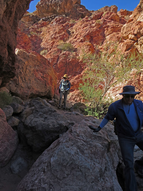
Geez Louise!! What about the washouts in Seven Falls Canyon??? The climbs are more slippery and the falls are deeper! And, one climb has pretty much disappeared. Funny thing, though. The "trickiest" climb (perhaps dryfall #3) is the same. Phew! There were a couple of hiker falls, too, but we all made it out alive. Over the last 15 years that I have been hiking this wonderful hike out to Cholla Forest in Teddy Bear Canyon, I have not noticed such a change from rainfall. We had sixteen hikers today that began from the Water Tank Trailhead on Cottonwood Road, a dirt road heading into the hills across Lakeshore Road from the Boulder Beach Campground.


Tricky Dryfall #3

Seven Falls Canyon

Saddle

Mt. Wilson from Cholla Forest

Teddy Bear Chollas
I took the first fall inside the rabbithole. It was a doozy. For the next mile, my camera was not working. Somehow it recovered near the top of Seven Falls Canyon. We made it up the canyon with difficulty and took the trail from the saddle down into Teddy Bear Canyon. We went straight to the teddy bear cholla grove and took our break choosing not to take in the small loop further up. After the break, we started down toward the connecting wash to Bacon Canyon. This canyon was a little less affected by the washout. Some of the dryfall bottoms were deeper but not all. However, in this canyon, it was easier to circumvent the drops. A large part of this group were newbies and I was surprised that so many of them chose to do the drop-to-the-side dryfall as seen five photos down.

Sixteen strong Hikers

The Game Trail

Descent of Bacon Canyon

Hiking around a Drop
The build-up for the colors of Bacon Canyon must have been a bit much because everyone was excitedly anticipating the display! When we reached the colorful vein of rock, we stayed to the left in the wash and dropped down without a problem. We usually see a lot of bighorns on this hike. However, the only two or three we saw were far up on the ridge peeking over and watching us as we started out. Kind of a stressful morning on what is usually an excellent hike. The group took it in stride as usual. (Pun not intended.)

Stats: 5.7 miles; 1200' gain; 4.5 hours

Fun little Exercise

Dropping through Bacon Canyon

Emerging at the Junction from Bacon Canyon


Thursday, January 25, 2024

Angel Dragon Scramble Loop - 1/24/24

Eleven Scramblers du Jour (I didn't get the wardrobe memo!)

Ash Canyon Overlook

Dragon Peak above Route

Girl Scout Trail
It had been three long days of rain and overcast. We were tired of sitting at home without a corner of our universe in which to hike. The rain stopped and the sun peeped out, if only for a couple of hours on the fourth day so, eleven scramblers came out of their burrows for a super-scramble on the wet sandstone ... well aware that that is not always a good idea. We were all very experienced and knew to take our time and be very cautious as we climbed, balanced and tested our shoe soles during the 5.5 hour adventure. We began our hike at the Kraft Mountain Trailhead and headed toward the Calico Hills and the Red Springs (aka Angel) Pass. After reaching the old abandoned house foundation, we climbed up to the Girl Scout Trail.

Starting up to the Pass

Climbing to Angel Pass

The Crack Ascent from the Pass

Resting on Angel Peak
A left turn on the trail brought us around the foot of the red rock and into the familiar canyon climb that we will call Angel Canyon for the purposes of this entry. This canyon tops out on Red Springs Pass which rises before you reach the Angel Carving on the other side. We climbed the hillside using familiar paths then turned to our right at the top. Above, the redstone peaks out on Angel Peak. Now, we faced the Crack Ascent leading up to the peak. It is a difficult scramble even on a dry day. With a little bit of wetness, we had to use extra traction from our shoes and a lot of extra arm strength. Help was offered to those who needed it. This was a close-knit group of veteran hikers who worked like a fine-tuned clock. But, with me in the lead, the clock might have been running a bit slow! (Darn knee.) After the Crack, we hiked through a large rabbithole constructed with huge boulders leaning against each other. Then, we scrambled up to the peak above where we had a short break.

Difficult wet Traverse

Climbing up to the main Calico Tank

Calico Tank full of Water

Crossing over to the other end of Calico Tank
The traverse that followed started with a drop down on the other side of the peak. The scrambling became a bit more intense as we dropped down another crack and made our way through the canyons to the Beach (aka Garden). In these small redstone canyons, there were several pools of water from recent rain. Everyone wanted to help out and find ways around the pools. Really, that just meant more scrambling! We made it to the Beach and began a serious climb up to the main Calico Tank. It's steep but there is a trail. One small break was taken on the way up as we continued to try to avoid the wet sandstone on the slabs. At the top, there were a handful of visitors taking in the views and we saw that the tank was very full of water.

Break Time

Starting down the Calico Tanks Trail

Mass Production Wall Ascent

Steep Ascent from Mass Production Wall
We continued to the other end of the tank and took our main break on some comfortable rocks. Laughter was heard throughout the hike! From there, we took the Calico Tanks trail down the CCC-made steps and stopped at the bottom of Mass Production Wall. With the rocks being wet, the climb up the drainage next to the wall was a little tricky. Some of the rocks are tilted slabs and there isn't a lot of room to side-step them. As we finished the wall, we stepped up onto steep slab. Up, up, we went until we topped out at a small vertical sandstone wall. This one is short enough to climb over where we ended up at the tank level cirque below Red Cap. Most of the group took a right passing the Sundial Tank. Others, took a left and reached the Wall Tank.

The Thomas's appear at the top of the Steep Ascent

Dropping down to the Tank Level

Circling around the Tanks

Wall Tank before beginning Descent
Both groups regathered down in the slot below the Wall Tank where we decided to take the safest way down to terra firma keeping in mind the wet sandstone. Bruno led the group along the wall to the left then dropped easily down to the Rattlesnake Trail. We veered to the right at a trail fork and headed straight for the top of Ash Canyon. The colorful wet sandstone appeared strikingly rich underneath the cloudy skies. We took the trail on the left side of Ash Canyon down to the second overlook where the abyss was a bit deeper. The trail in this area begins hanging off the edge of said abyss. We all knew care must be taken. We hiked the trail over to the top of Dragon Canyon, turned the corner and came to the view in the third photo.

Bruno leads descent to Rattlesnake Trail

Trail above Ash Canyon

Second Ash Canyon Overlook

Trail to Dragon Canyon Overlook
Dragon Peak rose up to our left and Dragon Canyon fell precipitously down to our right. We had heard a rumor about the changes that were made in Dragon Canyon by all the rains we have had this year. The trail started down fairly normal but deteriorated rapidly after it began disappearing. The mouth of the canyon was the most shocking! Much gravel had been displaced from the upper portion and dumped on the lower portion making the canyon a brand new adventure. Finally, at the bottom, the group of hikers dispersed making a beeline for the cars at the trailhead. Ash Creek Trail is in the perfect vicinity for this purpose. We all had a great, albeit long, day on the rocks!

Stats: 4.6 miles; 1750' gain; 5.5 hours

Careful on the Wet Stuff

Dragon Canyon descent through a very washed Gulley

Homeward bound on the Ash Creek Trail