Saturday, September 30, 2023

Capitol Gorge to Tanks (Capitol Reef National Park) - 9/25/23

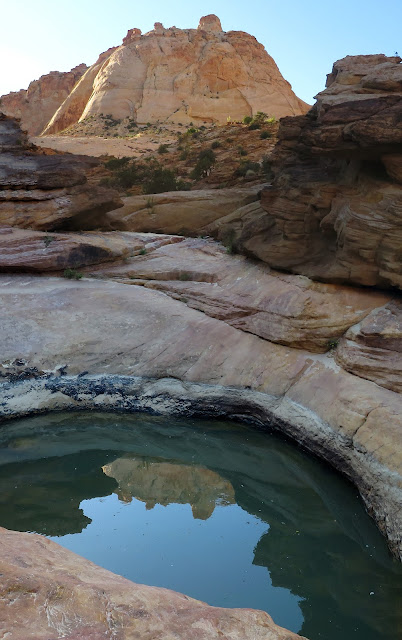
Second Tank above Capitol Gorge

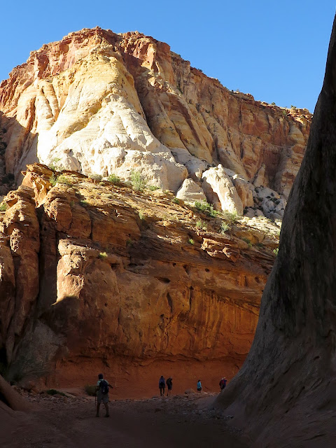
Our Hikers in Capitol Gorge

Landscape along the Capitol Reef Scenic Drive

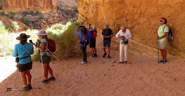
Starting into the Gorge (Petroglyph Panel to Left)
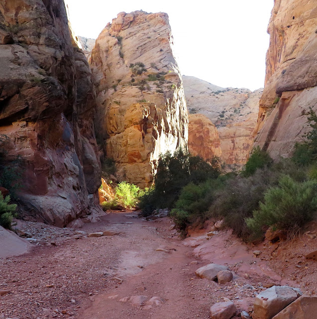
We arrived in Capitol Reef National Park in the early afternoon so a short hike was in order. We decided to take the drive down the Scenic Drive to the Capitol Gorge Trailhead and see if we could find the tanks at the end of the canyon! Two of us had been there many years ago and not been able to find the trail to the tanks. Now that we are a bit less "green," we had a feeling we would be able to find them! After 7.5 miles of pavement and 2 miles of dirt from the campground, the road ended at the Capitol Gorge Trailhead and, off we went! This was easy hiking but interesting ... a good first hike in the park. We perused the petroglyph panel found on the left just as we entered the canyon.


Trailhead Info Sign

Finishing up at the Petroglyphs

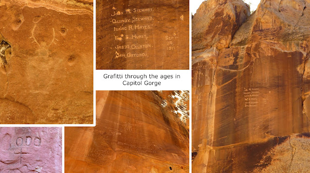
Petroglyphs and Pioneer Registries
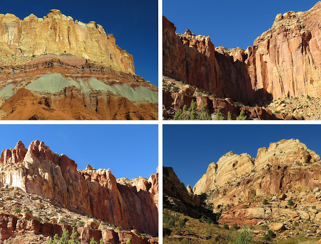
Capitol Gorge
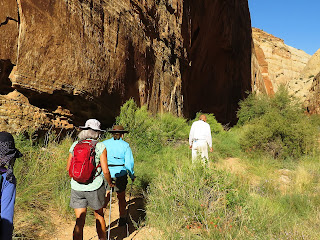
Passing through the narrow canyon, we also found three other "panels" on the walls. The park service calls these other panels, Pioneer Registries. We also noted five iron bars coming out from the walls in the canyon. We can only assume that these were grab bars for those unfortunate enough to get caught in a flash flood. The danger of such an occurrence is real, folks! My husband and I were caught in a flash flood coming out of the dirt road part of the scenic drive about 15 years ago. Yep. It was scary. But, we and the car survived! With one of the iron grab bars, there is a camera that we assumed was there to keep tabs on grafitti artists, flash floods and hikers needing help.
Grab Bar and Camera in Capitol Gorge (They are serious about flash floods.)

Gorge Scenery

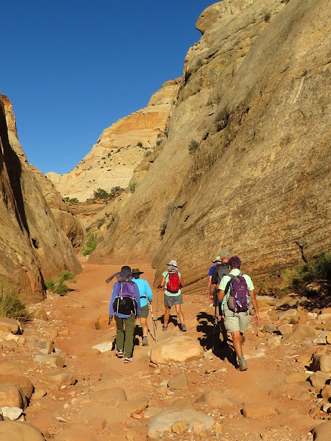
Hiking in Capitol Gorge

Terry gazes at the high-posted Pioneer Registry
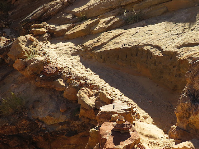
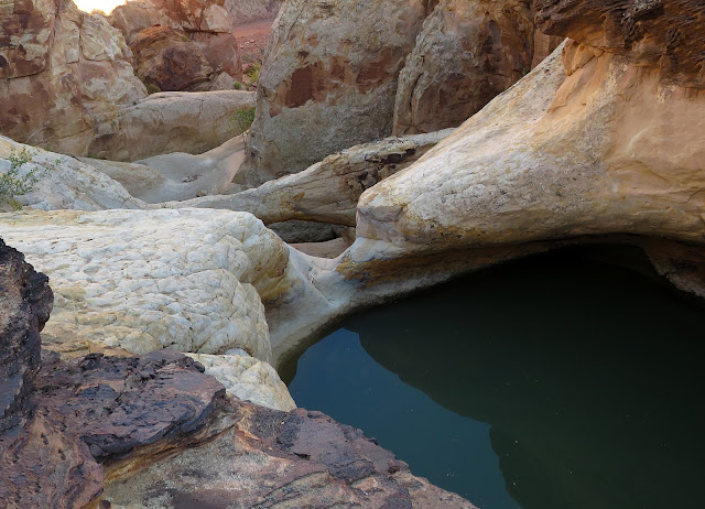
As the gorge opened out a little, there is a small sign on the left side indicating the junction of the tanks trail. Sure enough, there is a cairned trail heading up a small wash and winding around above until you can reach a larger wash where there are potholes that hold water. The tanks wash is beautifully carved where we found the first tank and a low lying arch just beyond. This first tank had a good amount of water, although, it was impossible to tell how deep it was. Some of the water in the park have the bad amoeba stuff in it. No way should you end up in any deep water inside the park! On up the wash, we found one other tank with a lot of water. We skimmed around a rock on the left side and hiked on up but this was the last one, we think. 

Climb up to the Tanks

First Tank with Arch

Squeezing around the Second Tank

Happy Hikers
After photos and fun, we tried to follow the tanks trail back. I don't think we were able to follow it back the same way, but we got there! Down at the signed junction again, we were a little confused about which canyon we should head back up. With the help of the GPS, we figured it out and went on our way. It was a delightful little hike. The gorge is impressive. And, the old grafitti connects us to the past. (My husband asked me if we waited until a rain storm was coming before we did it! ... Not this time!)

Stats: 2.7 miles; 220' gain; 1.75 hours
Danuta and David talk at the Second Tank

Climbing at the Tanks Junction (Trail Sign Below)

The Gorge as seen from Trail Sign


Capitol Reef Trail Overview

Capitol Reef National Park, UT - 9/25/23 thru 9/29/23 - Fruita Campground and Park Scenery

Horse barn next to Campground on Scenic Drive

Cliffs seen from Fruita Campground

Sunset on the Cliffs

Sunrise off of SR 24
Hello! I'm back from a wonderful, challenging, beautiful and fascinating trip to Capitol Reef National Park. Over five days, 10 hikers/campers hiked almost 35 miles! I took about 600 photos. There were a lot of hikers in the park. And, the waterways (i.e. rivers, creeks and ponds) were pretty full. Eight of the ten hikers camped in Fruita Campgound and two slept in the luxury of a hotel in Torrey. All were happy with their accommodations even though temps were low at night. Deer wandered around the campground. You would think that they lived there! Nicely, the campground was located on the scenic drive that takes hikers down to Capitol Gorge and other trails like Pleasant Creek.
Morning sun on Chinle and Moenkopi rock Layers

Good Morning, Capitol Reef!

Two Sentinels - Fremont Cottonwood Trees - "Mail Trees" for the previous Fruita Residents


Info Sign
Hikes that will be reported on are:

Monday - Capitol Gorge to Tanks O&B

Tuesday - Cohab Canyon / Cassidy Arch / Grand Wash Point to Point 

Wednesday - Pleasant Creek West O&B

Thursday - Hickman Arch and Rim Overlook

Friday - Lower Calf Creek Falls (an Escalante hike we did on the way home)

Stay tuned

Beautiful and friendly Horses by the Campground

Fascinating deer herd at the Campground

Just letting you know who's boss!


Capitol Reef Trail Overview

Saturday, September 23, 2023

Hidden Canyon / Bighorn Spur Loop - 9/23/23

Early Morning Sun on the Bike Trails

It was Saturday so we headed up to the Buckskin Cliff Shadows (Equestrian, Bike and Hiking) Park found within the boundaries of Red Rock Canyon NCA on the northwest side of Las Vegas. It was a perfect morning to hike with cloud cover and cooler air. Our hike took us past the large cave at the base of Summerlin Peak, to the bottom of Hidden Canyon and up through the main wash. At this point, the wash is a good scramble with humongous boulders to conquer! Actually, we found the way around most of them but it was a good puzzle to solve. After the scramble, we climbed up to our right to an out-of-this-world overlook of the canyon and city beyond. Next, we dropped down to Blazing Saddle and connected with the Bighorn Spur Trail. This trail took us back toward the cars connecting with the Toque Trail running along the base of Cheyenne Peak. It was a good hike with a speedy pace!

Stats: 5.8 miles; 1000' gain; 3.25 hours


Tuesday, September 19, 2023

Keystone Canyon - 9/18/23

Section of the Keystone Thrust Fault with Turtlehead Peak in Background

View down from above Thrust Fault

The Red Rock Escarpment from the Keystone Thrust Trail

In the washed out Keystone Wash
Have you ever done Keystone Thrust Loop in the CCW direction? Five of us did this little jewel for a beautiful ride! However, there were amendments to the original adventure. We parked at the bottom of the White Rock Spring Road at the junction of the Scenic Loop MM6 and hiked down the Grand Circle Loop trail for ~0.4 miles. This section of the loop trail is extremely washed out from recent storms and we lost the trail twice. (... and, we have all been on this section of trail many times!) In fact, we turned up in the wrong wash since this one had also become wide and gravelly. Finding the Keystone wash left turn, we started up the very washed out wide wash that, now, has 4-6 foot walls. It doesn't look much like it did before the rains! The culvert that runs under the scenic loop road, is absolutely clear ... except for the upper end where there is a serious tangled root obstacle. We got through but it wasn't easy! Next, the wash became a little more messy but still interesting and fun.

This used to be flat terrain.

The Culvert

Rita and Ralyn in the wash above the Culvert

The Scramble appears the Same
The scramble seen in the photo to the right was fairly normal in appearance except for a little deeper sand and gravel at the bottom. After that, the tree that used to cross the wash, was moved on down and is no longer an obstacle. From there up, it was clear sailing! We climbed the white rock 3rd class scramble on the right, on the trail to the side and also on the white rock on the other side. All routes were reported to be good. Next, we made our way up the beautiful rocks and climbed / scrambled all the way straight up to the Thrust Fault. We had two different fun routes going here! Finally, we sat at the overhanging rocks to take a break in the shade. The scenery was indeed better, in my opinion, taking the loop in the CCW direction but a view over our shoulders once in a while was also incredible.

Arriving at the top of the Scramble

Watermark!

Ralyn climbs up the Dryfall

Shade in Keystone Canyon
Keystone Thrust is the name for a prominent geologic fault in Red Rock Canyon. Faults are fractures in the Earth’s crust that occur from the movement of rock layers.

The Keystone Thrust is one of a series of faults that formed an estimated 65 million years ago, near the end of the Mesozoic geologic era – about the same time that the dinosaurs went extinct. At this time, the Pacific plate began moving under the North American plate. This caused compressional forces to push up older limestone rock layers over younger sandstone rock layers. At Red Rock Canyon, this is visible as grayish carbonate or limestone layers over red- and buff-colored sandstone.

This feature runs north & south for 13 miles along State Route 159, and curves at La Madre Mountain. It is one of the best examples of thrust faulting there is because you can stand along it with one foot on the younger sandstone rock layer and the other foot on the older limestone rock layer.


Therefore, we must recognize that the rocks we refer to as the "Keystone Thrust" is simply part of a whole that is most recognizable because you can see the two layers of rock that extremely slowly slide across one another. The remaining of the thrust fault can also be seen atop the Red Rock Escarpment where the limestone and sandstone layers come together as clear color change between the limestone and sandstone. Scientists come from all over the world to observe this area since it is one of few examples where this can clearly be seen above ground.

The Open fault area from Below

Succulent indigenous only to this area under the Fault

Another section of the open thrust Fault

A break in the Shade
After the rest, we climbed up to the trail on top of the open fault and followed it over to the Keystone Canyon again. To continue up the canyon, we were faced with about 4 dry falls, half of which were above our pay grade. We climbed up to the right side and followed a game trail up and around the first two dry falls and tackled the remaining canyon in the wash. The canyon became a class 2 climb until we hit the brush. There were trails on the side to get by the brush but this became tedious. Our target was to climb all the way up the wash until we could make our way over to Pinnacle Canyon and up. Keystone Canyon exhausted us as a whole so we stopped when we came to the La Madre Double Arch Trail agave roasting pit intersection. 

First Dryfall in continuation of Keystone Canyon

Bypassing the Dryfalls

East and West Damsel Peaks from Double Arch Trail Junction

Really rough Double Arch Trail
Leaving Pinnacle Canyon for another day, we took a sharp left turn and started down the arch trail toward the Keystone Thrust Trail. So glad we did! As it turned out, the arch trail was terribly washed out. Rocky and gutted. It was slow going on the trail so we did some of the descent on the side in the sticky Blackbrush. Should've worn long pants! When we connected with the Keystone Thrust Trail, it wasn't much better for most of the way. We turned left on the White Rock Hills Trail and hiked into the Upper White Rock Road Trailhead. Another halfish mile down the road and we were back at the car. The first half of this hike was amazing. The second half was exploratory and probably could use some refinement. Great time with friends.

Stats: 5 miles; 1200' gain; 4 hours.

View down to fault area from trail junction on Saddle

Keystone Thrust Trail nearing Upper Trailhead

Happy to be Back! (Really rough descent trail!)