Sunday, January 30, 2022

Jean's Peak Scramble Loop - 1/29/22

Jean's Peak from High Point (Bitter Spring Valley beyond)

Jean's Canyon near Arrowhead Road Junction

Redstone from Jean's Saddle Trail

Climbing up First Scramble Canyon
Over the years, I have done Jean's Peak Loop in a lot of various different routes ... some I meant to do and some I didn't mean to do! Never happy with any route for long, I kept searching for THE route that would stand the test of time. The Fearsome Foursome found THAT route today! We added a major scramble to the mix; one that CH had alluded to once upon a time. (But, next time we are bringing clippers!) 

We started the hike as usual from Northshore Road's mile marker 25. This is the turnout parking where a call button is located. We crossed the road heading uphill to the canyon you can see from the trailhead. A vague trail leads up on the right side of the canyon and drops in.

The Trip through the Triple Arch

Scramble out of Canyon

Approaching Saddle before Jean's Peak (Cairn, top-R)

Mike climbs toward Jean's Peak Cairn
This is a nice somewhat gentle scramble up until you become parallel with the triple arch on the right embankment of the ravine. We climbed up and did the required walk through. This put us on the trail that continues along the base of the rock cliffs. Soon, we found our new scramble up toward the top that we discovered last year. Up we went, zigzagging our way up to the large saddle below Jean's Peak and her large cairn. Continuing the climb, we reached the cairn and the high points on the ridge following. Back down to the cairn, we looked for the log book but could not find it. Is it there?

Rita standing next to Jean's Peak Cairn

View from Cairn to High Point Ridge

Eastern View from High Point

Fearsome Foursome at High Point
Here's where the new scramble came in. We started down from the cairn. Down, down, down into the canyon below us. There was a lot of slab to stick to. A steep waterslide appeared just before we dropped into the main canyon. A fun little challenge. Sheep trails sometimes led us through the brushier parts. Determined to stay in the canyon wash as much as possible, there were a few large old catclaw acacias in our way. Since they were old, we sometimes could break off the limbs to clear a path. There were places just above the canyon that promised an easier time but we steadfastly descended the wash where several fun scrambles resided. It took a while but, eventually, we found ourselves just below the high point saddle of Jean's Canyon.

Steep Waterslide into Descent Canyon Scramble

Descent Canyon Scramble

The Big Drop in Jean's Canyon

Points of Interest
We were in a little canyon of our own and had to find our way up to the usual trail that passes over the dried mud high point where there are a lot of bear paw poppies poking their hairy leaves out of the ground. Soon, we were descending down the other side of the saddle on the usual trail. This section was familiar but when we reached the Big Drop, it looked a little intimidating since we had not been there for a couple of years. We had no problems here and all of us but Mike, decided to do the go around for the Slip & Slide that came later. Next, we zigged and zagged on a gentle descent down to the old Arrowhead Road that runs within Pinto Valley. We rebuilt the cairn at the junction and turned left to follow the road and wash for 0.6 miles. There, we arrived at the Ridge Trail, Cut Wash, Arrowhead Road junction.

Mike descends Jean's Canyon

Below "Slip & Slide" and "Up & Around"

Old Arrowhead Road

Sea of White Hills
We zigged over to the climb up to the Ridge Trail and followed the ridge up to where it dropped back down on the old road and turned left. Not far was the right curve onto the steep road climb at the end of Pinto Valley. We came to where the land bridge trail crossed our path. We turned to the left yet again and began our climb up to Jean's Saddle, the last tough climb of the day. After a pause on the saddle, we followed the trail down the other side and dropped into the northern end of Jean's Canyon. A right turn pointed us in the direction of the cars. But, before we could start home, we had a few scrambles to deal with while we were being watched by eyes from the cliff above. Yes, a single bighorn perched safely high above.

Redstone from Ridge Trail

Small Break on Jean's Saddle

Jean's Saddle Trail inside Canyon (Saddle, top-L)

Slippery Drop in Jean's Canyon
By climbing over the saddle and into Jean's Canyon instead of following the two-track road out, we eliminated the long hike on Northshore Road to return to the trailhead. Cars on the road are zooming very fast here and it isn't safe to walk next to the road. We finished the canyon and found the cairn that indicated where to climb out on the left. There is a little bit of desert to hike out on before crossing the road to the cars. It was an excellent hike and will be repeated. ... with clippers! Fun and beautiful day!

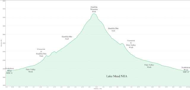
Stats: 5.8 miles; 1450' gain; 4.75 hours


We were being watched!

Last big scramble in Jean's Canyon

Out of the Canyon - Nearing Northshore Road


Thursday, January 27, 2022

Hamblin Mountain - 1/27/22

Lake Mead from summit of Hamblin Mountain

Six Hikers taking a break at the Petrified Wood

Again combining pods (two, this time), six hikers went to Lake Mead NRA to celebrate health! Starting from Northshore Road's mile marker 18 turnout, we hiked up Pinto Valley Wash to Hamblin Mountain. Today, we did the hike that contains a small loop in a clockwise direction. (The elevation charts below indicate the counter-clockwise direction that we usually do.) It was a fabulous day. No wind, almost, even though it was forecast in a big way. We saw sheep in a distant gulley when we reached the ridge below the summit. On the summit, we read the log book and saw that we had several friends that had climbed there just the day before. Great day! And, great friends! Beautiful views!

Stats: 6.7 miles; 1450' gain; 3.5 hours

Ralyn on Break

Bruce! Lookin' Good!


Wednesday, January 26, 2022

La Madre Double Arch v Pinnacle Canyon - 1/24/22

La Madre Double Arch from Approach

Eleven Great Hikers at the Arch

Arch Wash Terrain (Foreground)

Arch View from Keystone Thrust Trail
In a combination of three pods, eleven hikers started out at the bottom of White Rock Springs Road Trailhead for a strenuous hike up to the La Madre Double Arch. It was great to see everyone starting to come together after being two years into the COVID-19 pandemic although we are still alert on keeping our distance from each other. Not much hugging! 😕So, we walked up the road toward to upper trailhead and restroom. Btw, the road looks a lot better than it did two years ago and we probably could have driven up this time. After everyone was refreshed, we started up the White Rock Hills / Keystone Thrust Trail. A right turn up steps put us on the Keystone Thrust Trail proper. 

Keystone Thrust Open Fault Below

Hiking up the Ridge Trail

Dropping into Pinnacle Canyon Wash

Approaching Pinnacle Canyon
We climbed at a decent steady pace until we reached the Cactus Hill junction. Down below, we could see the open thrust fault area. However, our route, today, continued up the ridge we were on, on a good trail. Our pace stayed about the same until we reached a saddle area where a very non-pristine agave roasting pit marks the junction of a trail to the right. We turned and descended down to a big wash junction. The wash that we wanted to ascend was located past the initial wider wash going up to the left. We found it and dropped into a rocky smaller wash heading toward Pinnacle Canyon. To be clear, the easier route is to keep going straight up the ridge at the agave roasting pit junction. But, Pinnacle Canyon adds a little fun!

Pinnacle Canyon Scramble

Pinnacle Canyon 

Hiking up La Madre Wash

First View of Arch
We climbed up through the pinnacles in 2nd to 3rd class fashion until the wash leveled out again. The left embankment lowered down near our level and we climbed out crossing the trail that came up from the worn down agave roasting pit junction. Weaving our way through the low brush, we followed a kind of trail down to the main La Madre wash below. It is a wide gravel wash that begins a steep climb up toward the La Madre Range. As it climbs, it gets steeper and more scrambly. At this point, the pace slows considerably. We tried what looked like a shortcut to the right but I'm not sure that it is worth a repeat. It did pass up a few harder scrambles in the wash but, soon, we were right back in it. A rest pause in the shade was welcomed.

Best view of both Arches

View down from Arches Wash

Rita standing in the Arch from Uphill Side

Peering out from within Arch
The wash terrain was a little confusing and undefined so I understood how I missed the junction two years ago. My advice is to watch for a few newly placed cairns and to keep to the right. The Arches Wash begins steeply up at a very messy place but you can see the arch above you just before you have to deal with the mess. A few hikers in our group could not see the arch because it is a bit of an optical illusion! Don't expect to see sky through the hole until you are almost inside it! And, the smaller "arch" above the very large one can only be seen from certain viewpoints. All that said, it is definitely an impressively large arch. The best idea is to climb the wash until you pass it and find your way over to it from behind.

Preparing to descend Steep Hill to Wash

Descending Arches Wash

Scrambles

Charlie says "Hi"
At the arch, we posed for the group photo and took our break. Next, we followed the very steep and slippery trail back down to the Arches Wash. Continuing down the steep Arches Wash, we then connected with the main wash at the cairned location. Lots of scrambling going on! Relieved of the hardest work of the hike, we started down the main La Madre wash as it started leveling out. There are a couple of cairns marking the place where we dropped in from the ridge and that is an option for the return. However, we chose the main wash as the return route and continued crunching down the mostly gentle drop of the gravel. There are only three places of interest in the wash before reaching White Rock Hill below.

Descending out of the Main La Madre Wash Scrambles

Drop into Small Slot

Small Slot in Main La Madre Wash

Another small Drop
The first is a ~10' dry pourover that cannot be negotiated. No worries. There is a trail that leads around it on the right side. The second is a really cool short slot that you can drop into and pass through. Again, no worries. This can be easily circumvented on the left side. The third is a small rocky drop that can hardly be called a "scramble." As you near White Rock Hill in front of you, you pass over the White Rock Hills Loop trail. Continuing straight, try to not get caught up with the wide wash delta that has been created. Finally, you flow into the White Rock Wash that flows at the base of White Rock Hill and turn left. This is a beautiful wash filled with ... white rocks. Very photogenic!

Our hike finished as White Rock Wash junctioned with the White Rock Hill / Keystone Thrust Trail as it climbed out of the wash to the right and into the upper trailhead of White Rock Springs Road. Back down the road and we were done! Fantastic day! Quite the workout!

Stats: 6.5 miles; 2200' gain; 4.5 hours

Junction with White Rock Wash

Eleven enjoy the Colors

White Rock Wash