Saturday, April 30, 2022

Hanksville, Utah Excursion Overview - 4/25/22 thru 4/28/22

Map of the Excursion

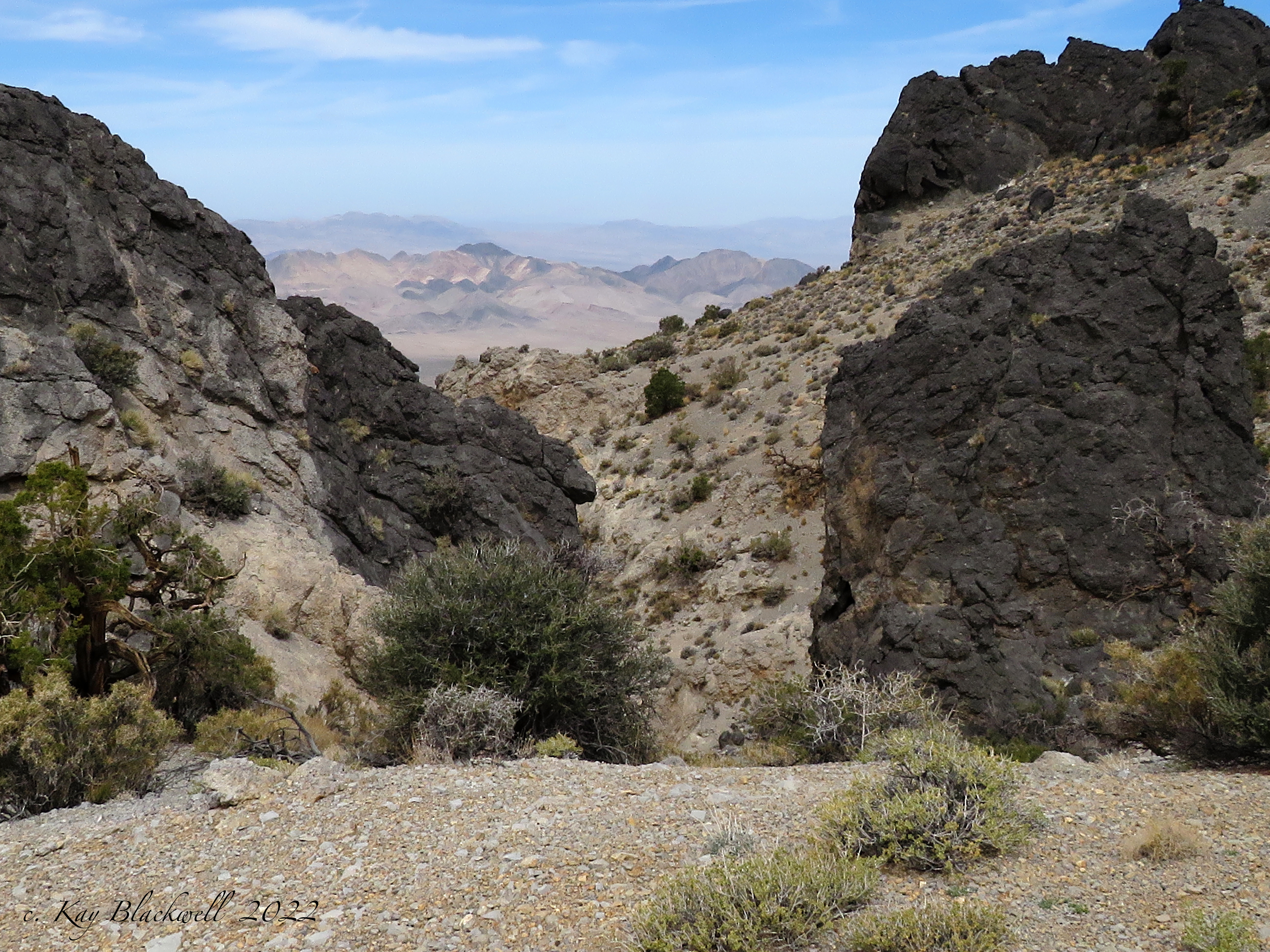
From Monday through Thursday, nine club members enjoyed a hiking excursion out of Hanksville, Utah. It was an eclectic week centering on ancient pictograph paintings and a few geologic wonders. We also enjoyed a little off-roading and the flavor of Hanksville, Utah. During the next week, I will be writing about each day and the adventures we had. This will include photos and maps, of course.

Petroglyphs in Capitol Reef National Park

Seven of us caravanned up through Capitol Reef National Park and took in the roadside petroglyphs.

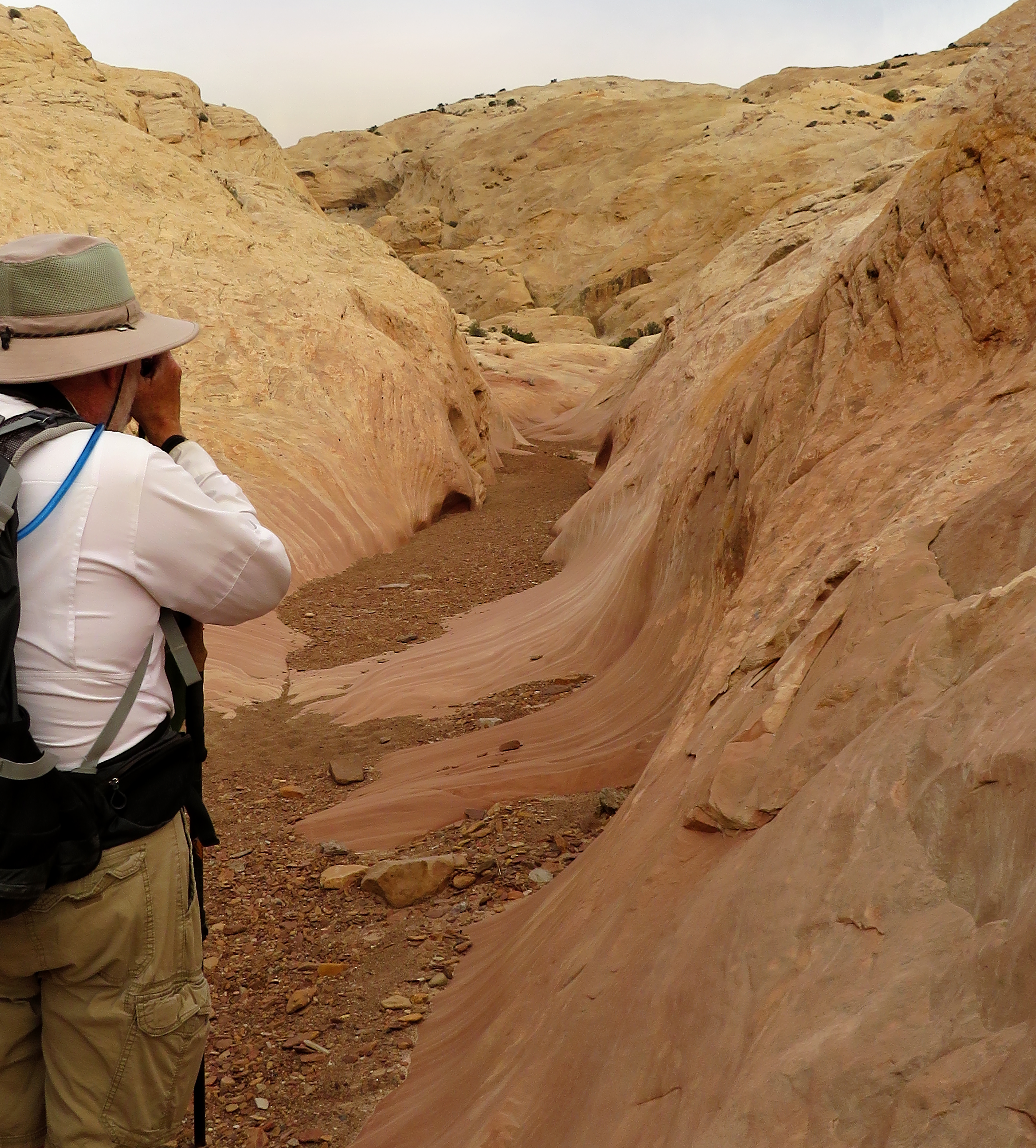
Long Dong Silver (I didn't name it.)

Next, we visited a very tall thin spire in a section called the Lower Blue Hills about 7 to 8 miles west of Hanksville. The spire was quite impressive!

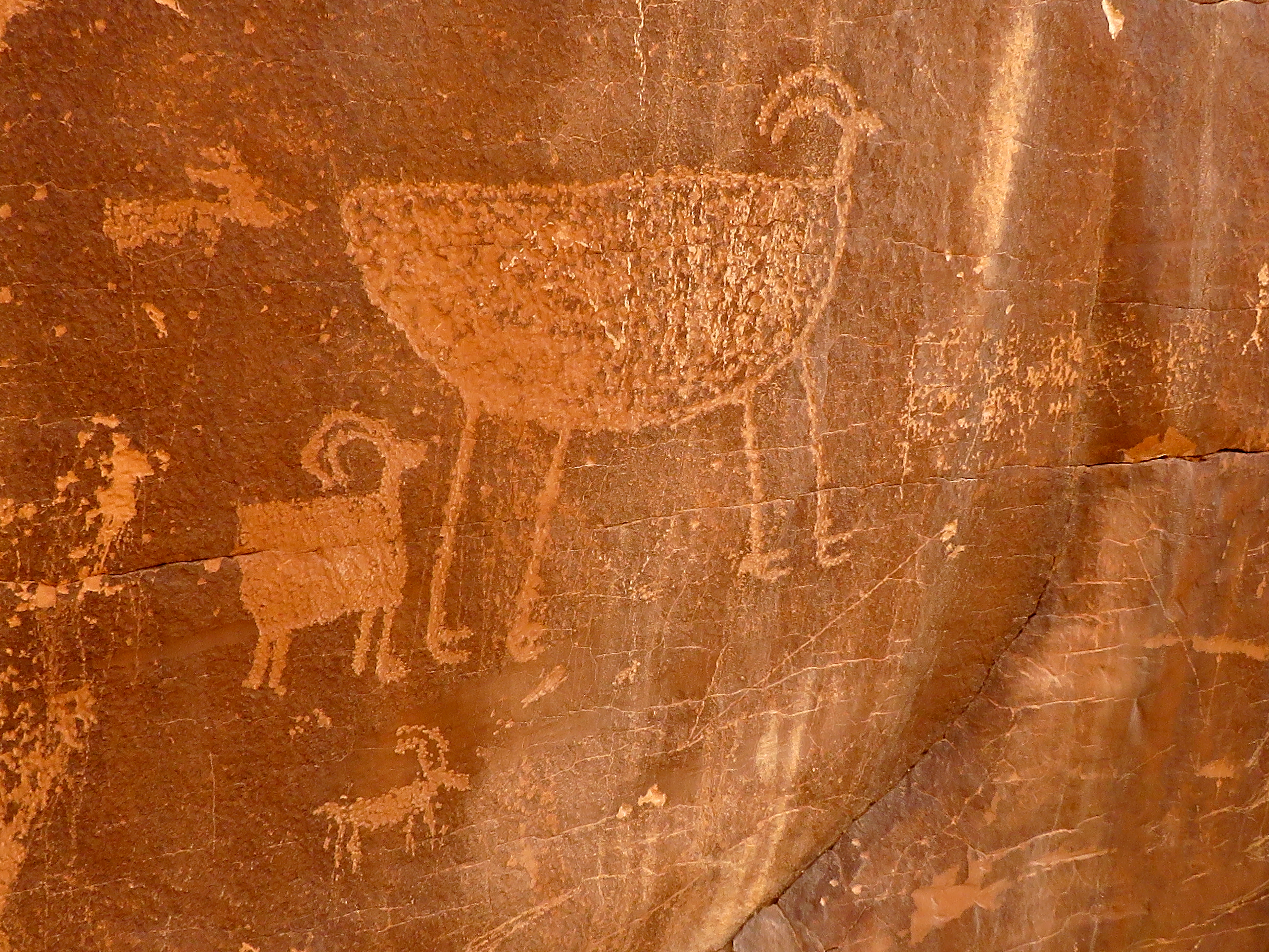
Moqui Queen Pictograph

Tuesday, we drove south from town on Utah SR 95 to the Hog Spring Picnic Area. A trail led us down along the roadside wash to a very large alcove where we found an exquisite pictograph called the Moqui Queen. She has suffered bullet holes but I used photoshop to restore her to her fabulous beauty!

Sandstone near Sandthrax Canyon

Next, we drove up the road to the Sandthrax Canyon Trailhead. Curious, we hiked over to the entrance of the canyon that only the craziest of canyoneers tackle. We explored up in the sandstone above it and discovered a trackway of some animal in the stone. Cool!

Petroglyphs at Sandthrax Canyon Trailhead

Back at the trailhead, we took a look at the petroglyphs nearby. They were pretty large!

Leprechaun Canyon

Driving back up the road about half a mile, we came to the trailhead for Leprechaun Canyon. The name is misleading though, until you reach the end of the huge cathedral-like entrance. Then, the canyon becomes very narrow - a la Sandthrax Canyon - slot. We thought about exploring further but .... Tight places just aren't my thing!

Little Egypt

Last on the agenda for Tuesday, was an area named Little Egypt. It is similar to Goblin Valley but more colorful and tighter in presentation. It was beautiful and magical so we wandered around taking photos.

Hiking Old Woman Wash Trail

The next day, Wednesday, we drove north on SR 24 to a gated dirt road just past the Goblin Valley State Park turnoff. This was a bad road that had been "improved" with a grater this season. The loose rock was still sharp and sticking up from the road. We were tooling along slowly when we reached a place where a wash had been flooded out. The go around was full of deep sand, hidden rocks, deep dips, etc. We all jumped out of our two cars and inspected the situation. Both cars were Subarus with 4WD so the drivers kicked it in and got through the obstacle just fine. 

"Unexpected Panel"

The road led to the Old Woman Wash Trailhead where we talked to two men who were camping there and had done our hike the day before. We followed their footsteps at times and easily found the "Unexpected Panel" of pictographs located 3.5 miles up the trail. David Morrow, our fearless leader, had done his homework and had the landmarks memorized and the waypoints lodged in his phone.

David Morrow in Wildhorse Canyon

On Thursday, we drove back up to the Goblin Valley Road and turned off to find the Wildhorse Canyon Trailhead. This hike and the day's before were located inside the San Rafael Reef Wilderness of the San Rafael Swell. We didn't have to hike up the canyon too far to find the alcove up high on the north side that held another ancient pictograph panel. All of the panels we saw were of similar styles ranging around 3000 years old. Amazing!

Wildhorse Canyon wash Pictographs

After we finished at this panel, we took a short cut over to the Wildhorse Window Trail. Fun!

Pictographs at Wildhorse Window and Rita

We followed behind another group of hikers from Holland who were heading to the window as well. After we passed them, we hiked up the wash to the very large alcove. Up on a shelf to the right, yet another pictograph panel resided.

Wildhorse Window

In the ceiling of the alcove was the window. It was essentially a very large hole in the roof! We sat for our break then returned by way of the window trail.

Temple Mountain Wash Pictographs

Lastly, Rita and I drove home by way of Temple Mountain Road. That was an adventure as well! Twenty miles of good dirt road and gorgeous scenery! Who could ask for anything more? 

Check back and see more details, photos and maps about each hike in the coming days.

Saturday, April 23, 2022

Red & Black (Boulder City, NV) - 4/23/22

Lake Mead from Red Mountain Peak

Spring Mountains and the Las Vegas Strip

Monkeying around at the start of the Zip Line

Starting up the Trail
Red & Black is an oldie but goodie. Yet, three of our great hikers today had never been introduced to it. Better late than never! We parked at the River Mountains Trailhead located off of Boulder City Parkway just up the hill from St. Jude Ranch for Children. We hiked up on the left side of the cement culvert and turned left to follow the marked trail through the desert. The trail swings out to the left then returns right, through a small canyon wash and ends up at a junction where we turned to the left. Here, we began hiking up next to the shallow wash that emanates from the division between Red and Black Mountains. Our trail eventually began climbing some fun switchbacks up the left embankment.

Red and Yellow Hills

View over to Lake Mead

Red Mountain, Saddle and Black Mountain Edge

Half Moon Setting
"We always see bighorns on this hike!" Nope, not today. It was very windy and, perhaps, they were hiding out from the harsh breeze. Anyway, we kept looking and climbing in and out of the wind as shelter was provided. Since three of our hikers were newbies, I enjoyed giving the tour. Dog Rock was first on the agenda. Next, the little cave. Next, the saddle. The full tour would not be complete without the climb up to the left onto Red Mountain Peak so up, we went. There were no bikers or zip liners anywhere to be seen at this point. The wind was terrible up on the peak but we managed a group photo anyway. After a short break, we headed down and back to the saddle.

Climbing the Switchbacks

View down to Boulder City from Switchbacks

Start of the Zip Line below Red Mountain Peak

Seven Hikers on Red Mountain Peak
Next, we started up the Black Mountain Trail. The views of the snow-capped Spring Mountains across the Las Vegas valley were crystal clear! All this wind is good for something! As we hiked, I pointed out River Mountain Peak, the highest point in the River Mountains Range. (That may be next on the agenda.) I pointed out the caldera ... that really isn't a real caldera and more like a flow field. We zigzagged up the trail ... looking for the non-existent bighorns ... and arrived at the overlook area where signage explained about some of the geology at which we were looking in the distance. I showed the newbies how to start along the ridge to get to the actual Black Mountain Peak. (That may be next also!)

Red Mountain Peak Views

River Mountain - River Mountains highest Peak

Climbing up to Black Mountain Overlook Peak

Dog Rock, Chuckwalla, Pineapple Cactus Bloom, Bikers
Views of Lake Mead, Fortification Hill, Red Mountain, Spring Mountains and Las Vegas were fabulous from the overlook. We took a leisurely break and started back down. It wasn't until a few minutes later that we began passing other hikers on this Saturday. An older couple (ahem, like us), a runner, a power walker ... and, surprise, Richard N. So nice to see him again! We stopped to watch bikers descend from Red Mountain.
Lake Mead from Black Mountain Trail

Red Mountain from Black Mountain Trail

Seven Hikers on Black Mountain Overlook Peak

Watching the Bikers at the Saddle
We stopped to talk to Richard for a couple of minutes. Onward and downward. We finished our hike via the culvert. On the way, we saw our first chuckwalla of the season. He was small, maybe a juvenile. I led a few hikers down by the culvert and Jerry led the other half down the middle of the culvert. Great day! Fun hikers!

Stats: 6.5 miles; 1550' gain; 3.75 hours

Switchbacking Down

River Mountains Trail

Culvert Walk


Friday, April 15, 2022

Hoodoo (Spire) Forest Loop (Desert NWR) - 4/14/22

Above Hoodoo Forest

Standing Rock

Descent Ridge

Cow Camp Road - Black Hills Pass

A hoodoo (also called a tent rock, fairy chimney, or earth pyramid) is a tall, thin spire of rock that protrudes from the bottom of an arid drainage basin or badland. Hoodoos typically consist of relatively soft rock topped by harder, less easily eroded stone that protects each column from the elements. They generally form within sedimentary rock and volcanic rock formations. Hoodoos range in size from the height of an average human to heights exceeding a 10-story building. Hoodoo shapes are affected by the erosional patterns of alternating hard and softer rock layers. Minerals deposited within different rock types cause hoodoos to have different colors throughout their height.

Leaving the Trailhead

Approach to Hoodoo Canyon

Window Hoodoo


Starting into the Narrows
In certain regions of western North America these rocky structures are called hoodoos. The name is derived from  Hoodoo spirituality where certain natural forms are said to possess certain powers, but by the late 19th century, this spirituality became associated with bad luck. Prior to the English name for these geographic formations they were already the origin of many legends from Native Americans such as Bryce Canyon National Park where hoodoos were considered petrified remains of ancient beings who had been sanctioned for misbehavior. Hoodoos are found mainly in the desert in dry, hot areas. In common usage, the difference between hoodoos and pinnacles (or spires) is that hoodoos have a variable thickness often described as having a "totem pole-shaped body". A spire, however, has a smoother profile or uniform thickness that tapers from the ground upward.

    Hoodoos typically form in areas where a thick layer of a relatively soft rock, such as mudstone, poorly cemented sandstone, or tuff (consolidated volcanic ash), is covered by a thin layer of hard rock, such as well-cemented sandstone, limestone, or basalt.

Small Scramble Up

Hoodoo Canyon

Color in Hoodoo Canyon

     
In glaciated mountainous valleys the soft eroded material may be glacial till with the protective capstones being large boulders in the till. Over time, cracks in the resistant layer allow the much softer rock beneath to be eroded and washed away. Hoodoos form where a small cap of the resistant layer remains, and protects a cone of the underlying softer layer from erosion. The heavy cap pressing downward gives the pedestal of the hoodoo its strength to resist erosion. With time, erosion of the soft layer causes the cap to be undercut, eventually falling off, and the remaining cone is then quickly eroded.
     Typically, hoodoos form from multiple weathering processes that continuously work together in eroding the edges of a rock formation known as a fin. For example, the primary weathering force at Bryce Canyon is frost wedging. The hoodoos at Bryce Canyon experience more than 200 freeze-thaw cycles each year. In the winter, melting snow, in the form of water, seeps into the cracks and then freezes at night. When water freezes, it expands by almost 10%, prying open the cracks bit by bit, making them even wider, similar to the way a pothole forms in a paved road.

Approach to Breaching Whale Hoodoo

Slippery Climb at Base of Breaching Whale Hoodoo

Fit Five at the Breaching Whale

Mike climbs up to the Ridge Above
In addition to frost wedging, rain is another weathering process causing erosion. In most places today, rainwater is slightly acidic, which lets the weak carbonic acid slowly dissolve limestone grain by grain. It is this process that rounds the edges of hoodoos and gives them their lumpy and bulging profiles. Where internal mudstone and siltstone layers interrupt the limestone, one may expect the rock to be more resistant to the chemical weathering because of the comparative lack of limestone. Many of the more durable hoodoos are capped with a special kind of magnesium-rich limestone called dolomite. Dolomite, being fortified by the mineral magnesium, dissolves at a much slower rate, and consequently protects the weaker limestone underneath it. Rain is also the chief source of erosion (removing the debris). In the summer, monsoon-type rainstorms travel through the Bryce Canyon region bringing short-duration high-intensity rain.

~Wikipedia
Desert National Wildlife Refuge - Sheep Mountain Range

Weathered Tree at Hike High Point

Communication Gap (Snail & Turtle)

Ralyn enjoys her new Hike
On a cool April day, the Fit Five hikers rode out to Wagon Wheel Trailhead at the end of Cow Camp Road in DNWR. As we were tooling through Black Hills Pass, we noticed that there were two large pipes sticking from the ground that did not have the protective large rocks on top of their openings. We stopped and fixed that. The road seemed to be in the best shape it has been in many years. A careful high clearance SUV could probably make the trip.
   We left the trailhead heading northeast to find Wagon Canyon's opening. Here, we got a nice view of the Hoodoo Overlook. The hoodoos on this hike are more like pinnacles and they are quite fat! We climbed up to the shelf on the right and crossed over to the next canyon to the right, Hoodoo Canyon. The pourover here and the one we see at the bottom of Teresa Canyon later, are used for learning rappelling and other rock climbing activities. We turned to begin ascending gravel in Hoodoo Canyon by passing the Window Hoodoo. Right away, the canyon was filled with hoodoos on the ridgelines. The canyon became more narrow as we climbed and more hoodoos appeared lower down. Soon, we were climbing bigger rocks and passing hoodoos at our level.

Hoodoo Ridge above Teresa Canyon

Hoodoos below Hoodoo Ridge

Desert Colors

Rising higher than the other hoodoos was the Breaching Whale Hoodoo. This anomaly marked the narrows of the wash, a slippery steep climb up a pourover. After that, the route veered to the right onto the ridge where we climbed steeply to the main ridge above. Once there, we turned right to reach the hike high point and continue around the ridge that runs above Teresa Canyon, Hoodoo Ridge. From this height, we could look down on Hoodoo Forest. There are dozens of pinnacle hoodoos puncturing the air below the ridge. We continued around the ridge admiring the views. At first, we thought that the black Standing Rock formation had fallen down and we were giving it an elaborate memorial eulogy as we hiked. But, wait! There it is! You just can't see it until you get to the other side of Teresa Canyon. It is quite the spectacle.

Large Hoodoos

Picture Canyon at Left - Large Hoodoos to Right

Large Hoodoos on Descent Ridge

Jerry & Cheryl Descend from Break Point
We took our break before we began our descent on the ridge to the south of Teresa Canyon. There is another ridge forking down from our position as well. This ridge runs above a wide canyon that flows into Picture Canyon right at the junction that contains a very large ancient agave roasting pit. See the second photo above this. After the break, we dropped down on the descent ridge and weaved our hike through very large fat hoodoos. We noticed that there has been a recent landslide inside Teresa Canyon. It appears that a hoodoo split and caused rocks to slide down about 100 feet. Maybe that was the result of "frost wedging" as described by Wikipedia above. 

Within the Large Hoodoos

Pointy Hoodoo

Recent Landslide below Standing Rock and Communication Gap

Hoodoo Forest at Top of Teresa Canyon
The descent continued down the ridge to a saddle where a trailing ridge to the right connects. The trailing ridge is the most gradual descent into the canyon that is offered. In the canyon wash, we had just a few gentle scrambles to contend with then we turned to the right onto a vague trail above the pourover at the end. The trail led us over to the vicinity of the Hoodoo Canyon pourover where there is a gentle scramble down to the desert floor. All that remained was a hiked down the abandoned dirt road that runs from there to the trailhead. What a beautiful day with great company!

Stats: 4.7 miles; 1670' gain; 4 hours


Descending Teresa Canyon

Last Big Scramble

Return to Trailhead