Sunday, April 30, 2023

Kyle Canyon Escarpment - 4/30/23

Charleston and Griffith Peaks from Kyle Canyon Escarpment

Thought I’d venture a peek at the Escarpment Trail on this final day of April. I had my doubts about completing the circuit, but it turned out that the entire trail was free of snow and bone-dry. Go figure. Snow level looks to be around 7500’.

Kyle Canyon Wash with Water

Can’t say the same for Griffith & Charlie. Maybe Labor Day. Above is a rarity below the Visitor Center: water flowing down from the campgrounds through the normally dry creek bed.

Near the Visitor's Center

A man likes a nice rest area at the end of a grueling hike. Complete with water cache. Ta-da!

~ Mike O'Connor 😃

Thursday, April 20, 2023

Red Rock Wash / Rocky Gap Road Loop - 4/20/23

Red Rock Wash and La Madre Mountains

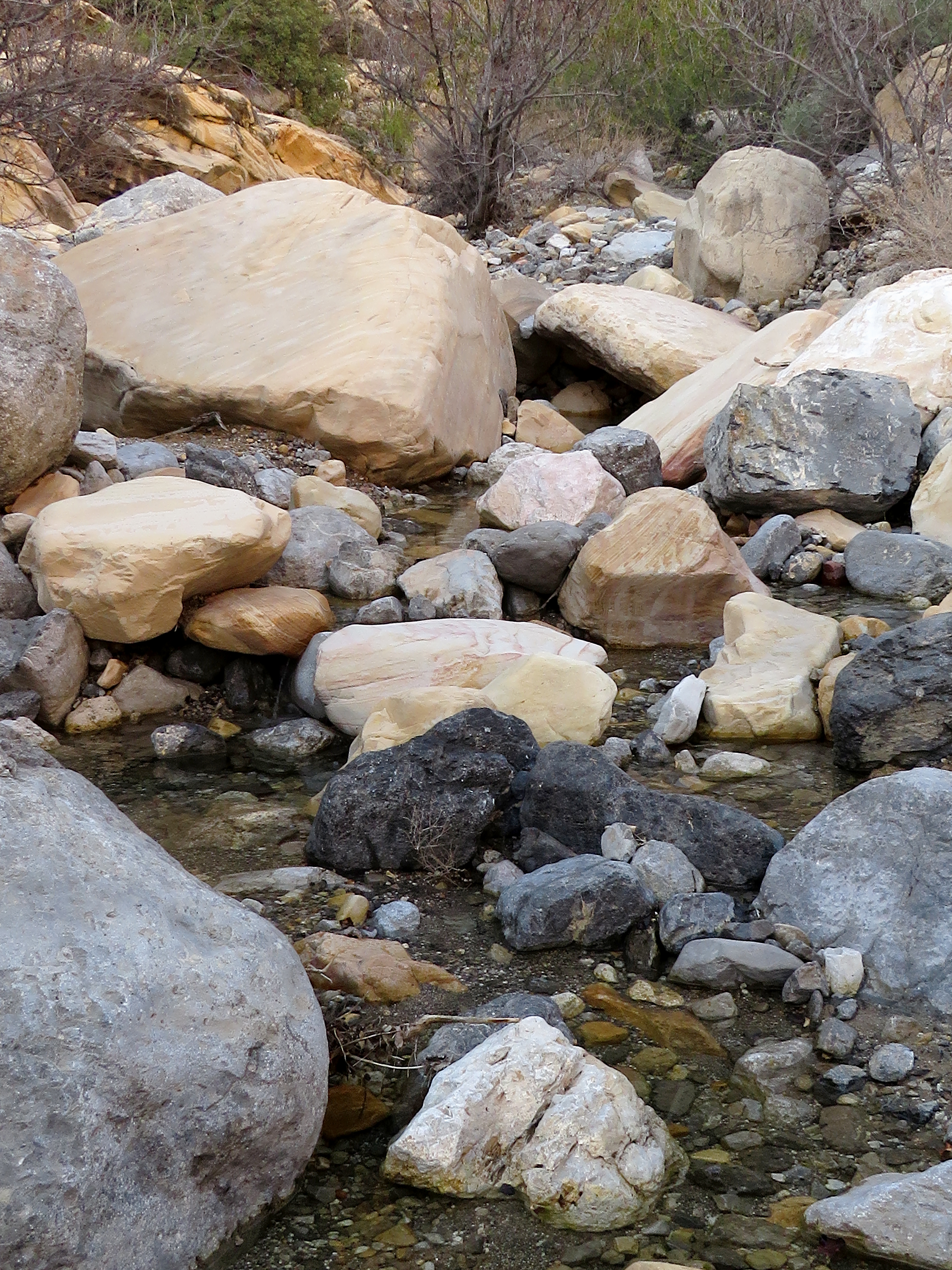
Surprising amount of Water in Wash

Petroglyphs at Willow Springs Trailhead

Starting into the Wash
We were seventeen strong club members, but, no worries, our hike was not going to enter into either of the wilderness zones that neighbored either Rocky Gap Road nor Red Rock Wash. We were climbing up through the normally moderate scramble of Red Rock Wash and down the old dirt road. However, there was quite a bit of water flowing down the wash ... a sight that none of us had ever witnessed before! This turned our moderate scramble into a moderately strenuous scramble and we were in for a treat! The water was crystal clear and sounded like a beautiful bubbling brook. Several of the scrambles were blocked by deep water so we had to get creative. 
Dodging Rocks

Dodging Water!

John Ward boulder Hops

Enjoying the Day
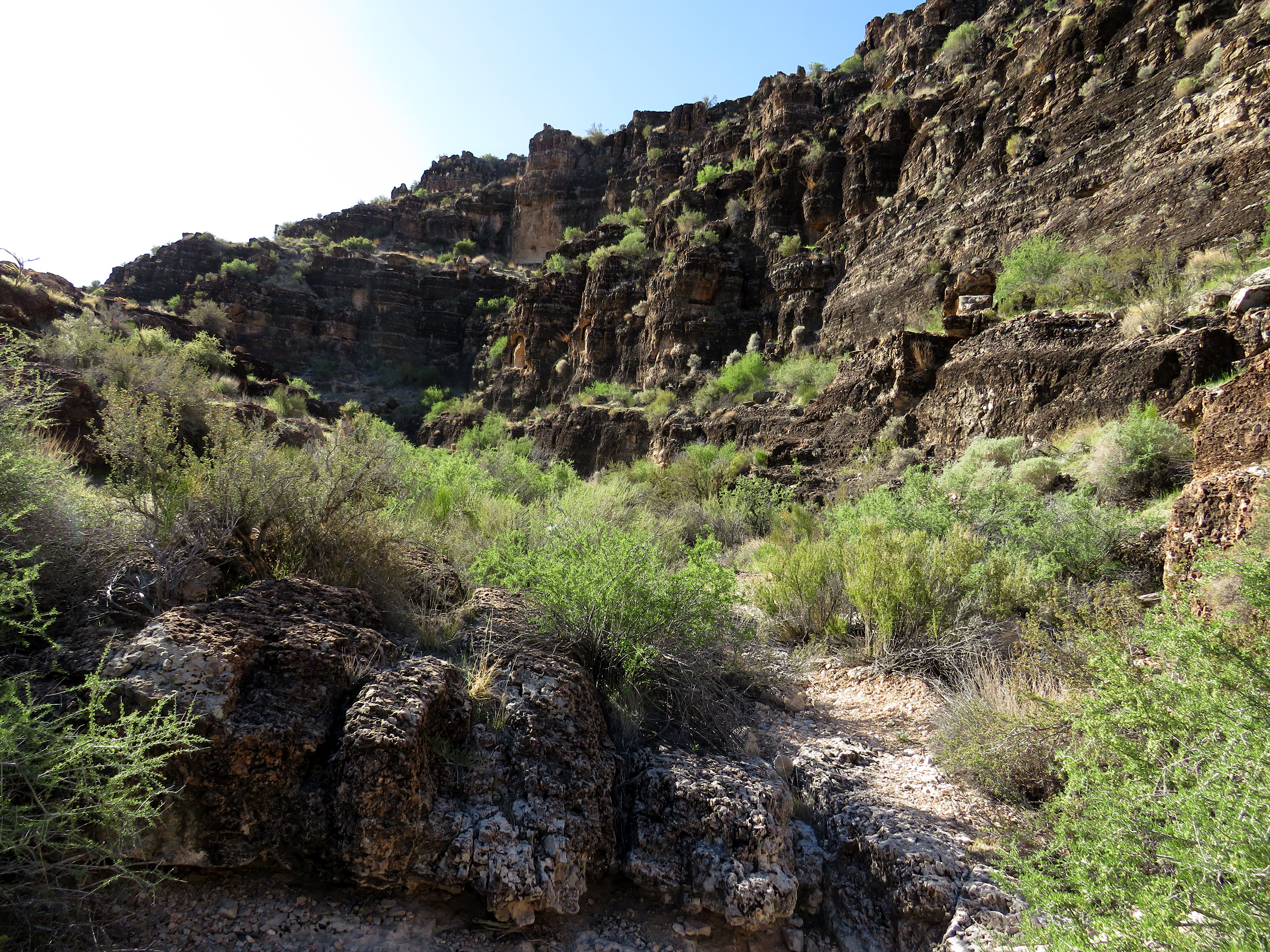
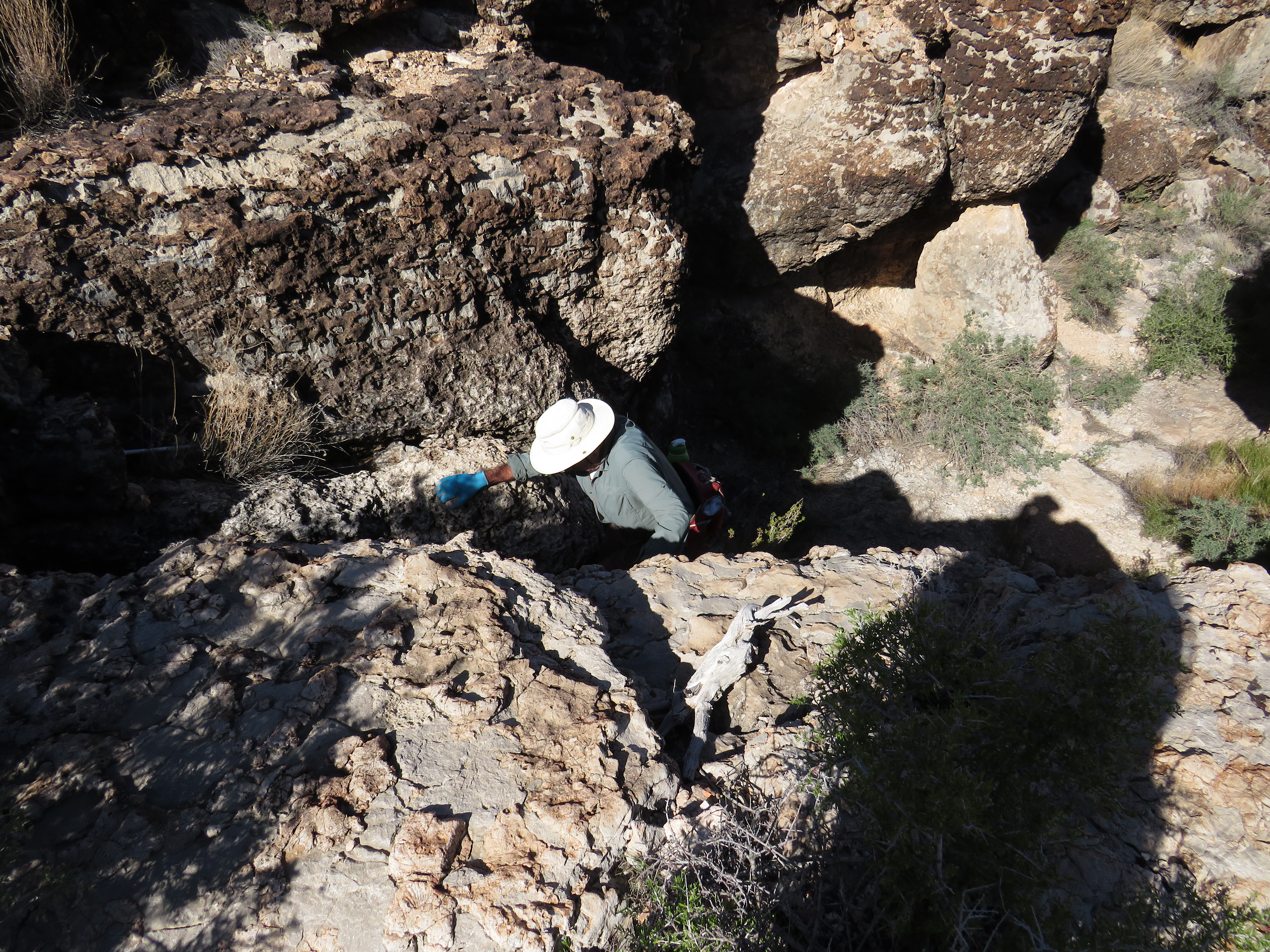
So, after a short visit over at the petroglyphs we started up from Willow Springs Trailhead. Our long line of hikers slowly hiked up through the rocks and then through more rocks lined with a mountain stream. Ocassionally, we would need to stop and make sure that the line was together. But, mostly, everyone was up to the task. The only place we had to exit the wash for any length of time was the spring section. Here, there is a lot of brush that grows up from the normally wet area. We climbed up to the right and found a brushy trail to follow. After this area, we came to the large dry fall. Thankfully, the dry fall was ... dry! We climbed up and continued to where the North Peak (Sandstone) Trail crosses the wash.

Scrambling around the Water

Small Waterfall

Debbie in Reflection

One of many Patterned Rocks
Here, we turned to the right and connected with Rocky Gap Road. Everyone had smiles from ear to ear! We had conquered the wet wash and no one got more wet than planned! And, oh, was it pretty! Our hike began its return on Rocky Gap Road at a moderate pace. We passed by the large dry fall overlook, the road shortcuts, the entrance to Waterfall Canyon, the Pink Jeep turnaround (complete with a Pink Jeep and car load of people). On down, we passed the trail junction to The Promised Land Wall and the La Madre Spring & Cabin Hike. Finally, we hiked into the Willow Springs Trailhead where there were cars and people everywhere.

Starting around the Spring Section in the Brush

Some Algae in the Water

Nearing large Dry Fall

Climbing large Dry Fall
Today's hike was fluttering with conversation and happiness! The club is thriving now that the pandemic is nearing its end.

Stats: 4.6 miles; 800' gain; 3.75 hours


Starting down Rocky Gap Road from Junction

Rocky Gap Road

Nearing the Trailhead
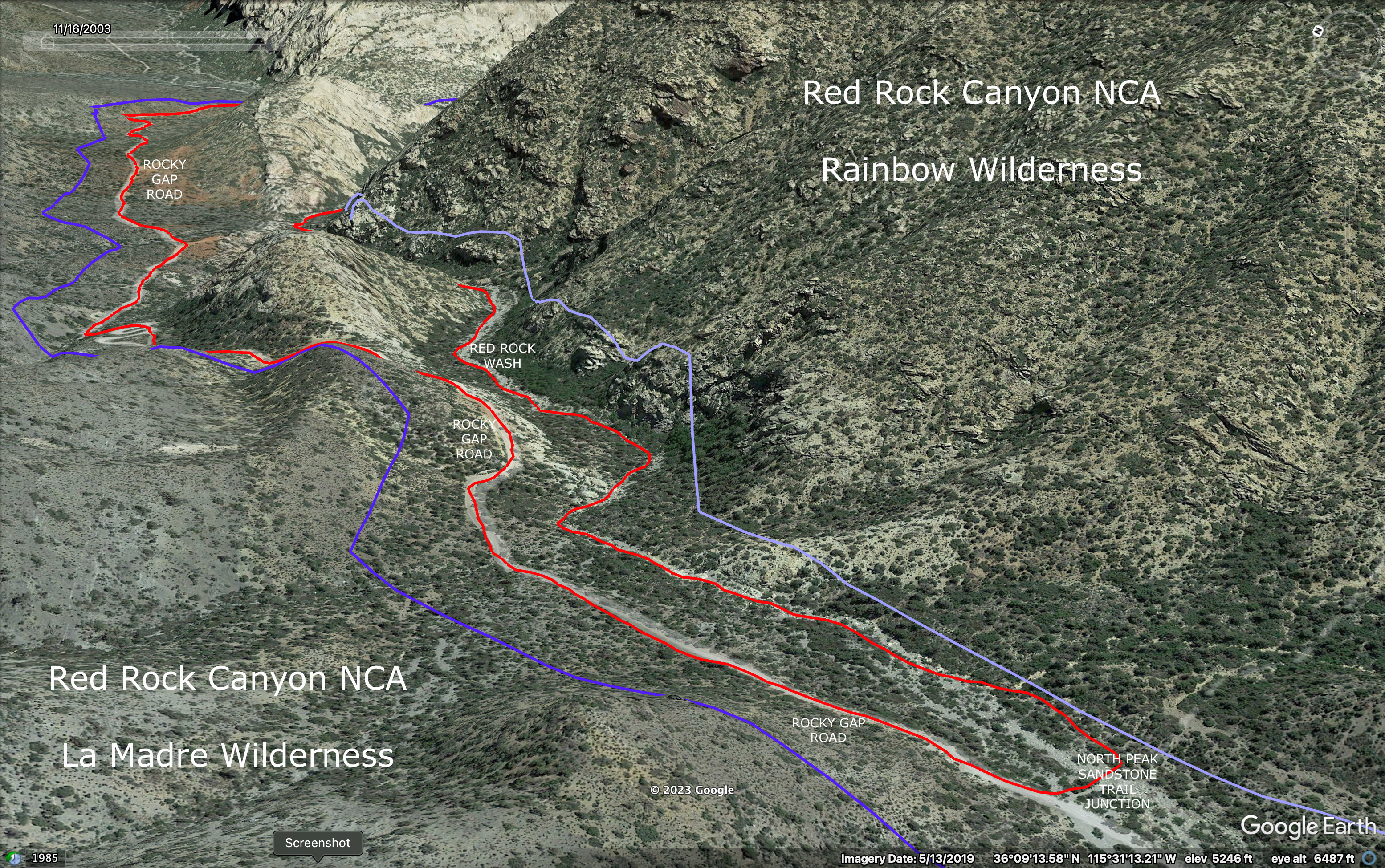
Our Trail = Red;
Light Lavender = Rainbow Wilderness Boundary
Purple = La Madre Wilderness Boundary

Tuesday, April 18, 2023

Cave Canyon / Fossil Ridge - 4/17/23

The Ladder in Cave Canyon

Fossil Ridge

The Entrance to Cave Canyon

Climbing into Cave Canyon
What is a winter season without doing our beloved Cave Canyon? Cave Canyon holds several caves within its walls that we have long before visited. Now, the canyon is one of our favorite scramble destinations. Two miles of class 2 and class 3 scrambling keeps you busy for quite a while. So, we parked at the Cowboy Trails TH and headed up to the canyon entrance found behind the upper horse stables. Take the left fork. The canyon entrance trail climbs steeply up on the right side of the wash. The fun begins at the top. Very soon, there is an overhanging dry fall of maybe 20 feet. We used to have to climb this with only the help of a big pile of rocks at the bottom. Now, there is a rudimentary wooden ladder. Climb it at your own risk!

The Trail into Cave Canyon

Ralyn's first time in Cave Canyon

Narrow Walls in Cave Canyon

Enjoying the Scramble
It was Ralyn's first time in Cave Canyon and we  enjoyed her maiden climb with her. Weaving in and out of the rocks and brush. Climbing here and there. We followed our choice of trails. To our right were the cliffs of Second Finger. To our left were the walls of Boneshaker Hill. It was a beautiful morning. We expected wind by noon but breezes barely made any appearance before the end of our hike. Temperatures were optimal. Reaching the canyon fork, we turned into the left wash. Again with the weaving, we made our way up to the "dead end" dry falls. Explaining to Ralyn, there are three possibilities. The easiest way up is to the left. The medium difficulty climb is to the right. The most difficult way out is straight ahead.

Cave Canyon

Hiking up through the Left Fork

Mike tackles the Climb Out

Four on the Floor on Break
We all climbed out the latter route and hiked on up to the SARS Trail that crosses the wash perpendicularly. Turning to the right, we began our hike over to the top of the Cave Canyon right fork, Second Finger, First Finger and the top of Echo Canyon. We took our break in some shade and watched a large collared lizard scramble by. At the Echo Canyon / Fossil Ridge Trail junction leading down to the right, we turned for our descent. Here, we began paralleling another larger group of hikers who were using Cat 'n' Hat to descend above Fossil Ridge Trail. We hiked down into Echo Canyon until the Fossil Ridge Trail starting traversing the hillside. We continued down the beautiful traverse where the views never disappoint.

Descending to the Fossil Ridge Trail

Fossil Ridge Trail above Echo Canyon

Beautiful Scenery on Fossil Ridge Trail

Overlook into Echo Canyon
We passed a few more hikers on Fossil Ridge and the large group behind us dropped onto our trail as well. While they turned left to continue the Bunny Trail, we turned right to continue Fossil Ridge. The red barrel cacti and the red of Calico Hills brightened the scenery. A short stop to yell "Hello" at the echo point then onward above the upper horse stables. Down Fossil Ridge twisting right and left on a well-maintained trail that is used for horse rides, we dropped down to the trailhead. What a great day! Done before the wind!

Stats: 6 miles; 1140' gain; 3.5 hours

Echo / Cave Canyon junction below Fossil Ridge

Upper Stables from Fossil Ridge

Descending to the Trailhead


Saturday, April 15, 2023

South Canyon Bike Trail (aka Angel's Landing) - 4/13/23

South Canyon and Bike Trail

Trail Work in South Canyon Narrows

Entering South Canyon on Bike Trail

Windy Morning below SR 160
 When we started out there was a bit of gusty wind and it really didn't die down until we were over halfway through our hike. This was a new hike for us although Rita and I had explored the top part of it a couple of years ago. Ever since then, I had been looking for a better trailhead from where to start and I never did. When NDOT did the construction on SR 160, they neglected to place a more convenient trailhead next to the road nearer South Peak, the southernmost peak in the Red Rock escarpment. I believe other hikers have taken to parking on the side of the road and climbing over the wildlife fence. I didn't want to do that and it turned out that we didn't really need to. Our 6 mile hike was just right!

Nearing South Canyon

Trail Work below SR 160

Bikers, Watch your head!

Nearing Narrows
This hike explored the completion of a bike trail that travels the south side of the South Canyon, on the south side of South Peak! To make a loop, we also used the old powerline road that ran up the north side of the South Canyon. Here, I would like to say that the bikers did an outstanding job on the bike trail portion of this hike while constructing it. The bike trail is not only well constructed but is also made beautiful by the choices they made. Kudos! So, we drove up the dirt road that turns north two roads up from the Late Night Trailhead. Following the road in the direction of South Peak as far as it would take us, we parked right there at a sharp corner where the road turns back on itself. We started hiking toward South Peak in the gravel wash.

South Canyon Narrows

Climbing up on Powerline Road

Powerline Road

Powerline Road
Eventually, we came to the bike trail that crossed the wash and turned left. This trail is very clear and it took us up the south side of the wash then crossed the wash to go along the north side until we reached the narrows of South Canyon. Wishing to ascend via the old powerline road, we turned right on a steep hill and began following the road which is only clear due to the fact that it is much less brushy than anywhere around it. After taking a short cut through the left side, we dropped down into the canyon wash below. The road continues up the wash until it is clear that it begins to climb the hill on the south side of the wash. This hill turned out to be the steepest and longest hill of the day. Along the way to the high point, we crossed the bike trail.

Climbing out of Canyon on Powerline Road

Interesting Trail Stuff

Mike's Canyon to Hollow Rock Peak

Saddle Turnaround Pinnacle
When we crested the top, the road leveled out and we turned right onto another abandoned road we were very familiar with from our hikes to Hollow Rock Peak. Very soon, we came to a very clear turn to the right to reconnect with the bike trail. From here on, the bike trail led us clearly along the side of the canyon. We took a break where it appeared wild burros had bedded down at one point. The trail is beautifully made along the cliffs and out to the end of the bench. From there, it zigzags in bike trail style all the way down to the narrows portion of the canyon where we were before we turned up on the powerline road. Following the same trail, we returned to the original wash and decided to keep going to see where the trail ended up.

Bike Trail above South Canyon

Taking a Break at the Burro Bed

Bike Trail

Bike Trail nears end of Bench
Just after we crossed the wash on the bike trail, we passed by an old car that was covered with sand and gravel many years ago. Someone had placed the required plastic skeleton on the drivers' seat. The trail seemed to be heading in a good direction for most of the way but took a slight turn to the north. Turning east again, the trail followed a long low ridge or berm alongside the washes. Again, we seemed to be going in the correct direction to find our car. Finally, we spied the car not far to the east southeast. A short bushwhack took us down off the berm and back to the car. This was a great hike at just the right distance. Again, kudos to whoever built this beautiful trail!

Starting down to Narrows from Bench

Outstanding Trail Work in Narrows

Canyon Narrows

One Big Red Rock!
If you wish to do the entire bike trail, you would need to start at Mountain Springs Trailhead and do a point to point hike down to the Late Night Trailhead. Either way, we enjoyed our day very much.

Note: RRCNCA has named this trail Angel's Landing akin to the one in Zion NP. From now on, I will use this name.

Stats: 6 miles; 1150' gain; 4 hours

Re-Entering Cottonwood Valley

Possibly a 1958 Mercury Turnpike Cruiser

View from Bike Trail to Calico Hills through Cottonwood Valley