Tuesday, November 29, 2022

Red Cap South v Ash Canyon & Dragon Canyon - 11/28/22 - Mike O'Connor & Ralyn Conner as Guest Bloggers

Three Tough Scramblers

Climbing in Ash Canyon

Looks like fun! - This starts the drop down to Ash Canyon.

Autumn in Ash Meadow

The guest blogs are coming in and I'm so happy to see them. This blog is from a fraction of the Six with Sticks plus wonderful hikers from our rolodex. Ralyn joined Mike with taking some excellent photos. And, Mike (writer extraordinaire), wrote the narrative as it is written below. It appeared to be a gorgeous autumn day and the hike / scramble looked to be a whole lotta fun! Thanks everyone for this great coordinated effort.


It begins:

Approaching Ash Canyon

Climbing to the South Trail of Ash Canyon

Some Exposure in Ash Canyon

Getting higher in Ash Canyon

It was decision time: Red Cap North or South? Hmm.


The last Monday in November dawned crisp and cool as five veteran hikers assembled at the boardwalk in Calico Basin. It was a splendid day for a scramble. Gazing up at the Grand Staircase on our southern flank, we proceeded west toward Angel Pass, then veered north for the picnic tables and Ash Meadows. Entering Ash Canyon, we hugged the south side of the canyon and started up the steep sandstone slab. It provides a good workout, while offering a wee bit of exposure. It’s an old Doyle Ryan route, always a keeper.


Reaching the top of Ash Canyon

Scrambling up the North Side

Shadowplay

Tinaja on Red Cap South

After a brief snack at the top, we began our second climb of the day to the next level, arriving at the base of our destination, Red Cap. About that decision: Ralyn and Ralph had never visited the southern cap, so the three of us trudged off in that direction, while the Anthem duo of Mark and Steve went the opposite way to Red Cap North. Both routes are decent scrambles, but the southern circuit presents a bit more of a challenge with some Class 3 chutes. We abandoned our cumbersome packs and ditched our poles for the final push to the summit. And in the end, Ralph & Ralyn managed to add a new peak to their mountaineering portfolios. Hear! Hear!

Interesting Scramble off Red Cap South

The Chute that helps connect Red Cap South to North

Re-Gathering at Junction

Back at the top of Ash Canyon

Following the summit bids, our two divergent groups met for lunch back at the lower junction. We retraced our steps back down to Ash Canyon, then mixed it up a bit by taking the north side back down to the meadows via Dragon Canyon. A final, one-mile streak across the desert floor landed us back in Calico. Another glorious day in the Red Rocks.


Vitals: 5.99m., 1857’ vertical, 4 1/2 hrs.


MOC


Dragon Canyon Descent

Reaching the bottom of Dragon Canyon


Wednesday, November 23, 2022

Valley of Fire Beehives Section (Pre-Hike) - November 2022 - Brian Dodd (Guest Blogger)

This is a guest blog composed by Brian Dodd with photos by Shirley Grimm.

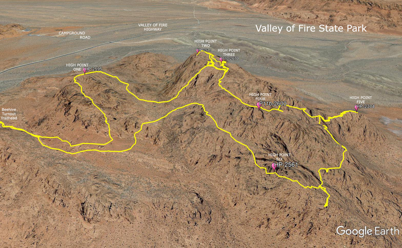
Valley of Fire Beehive Terrain

Starting out in the Cool Still Morning

Typical Sandstone Rock Jumble up to the Left

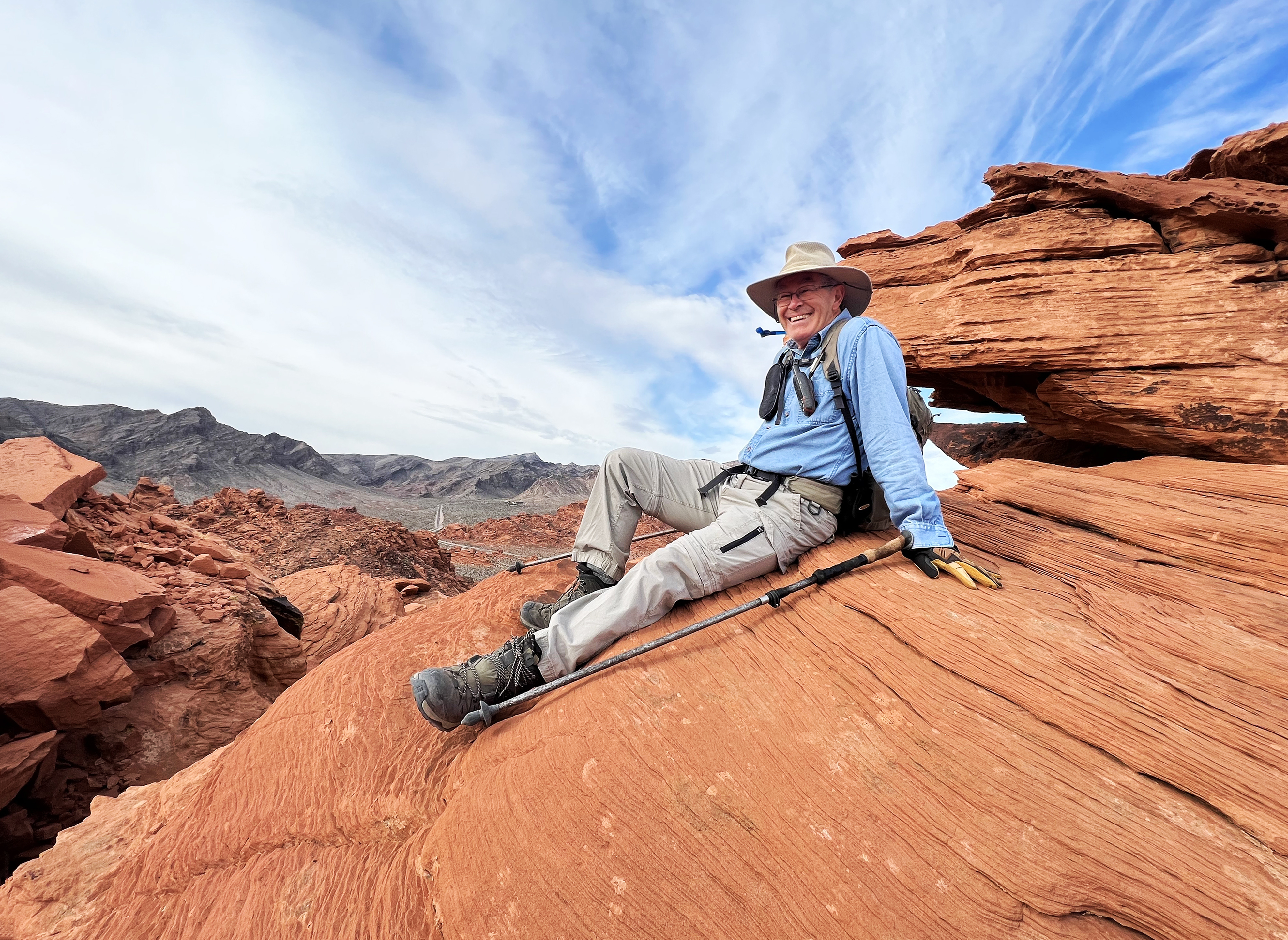
Brian on High Point Two

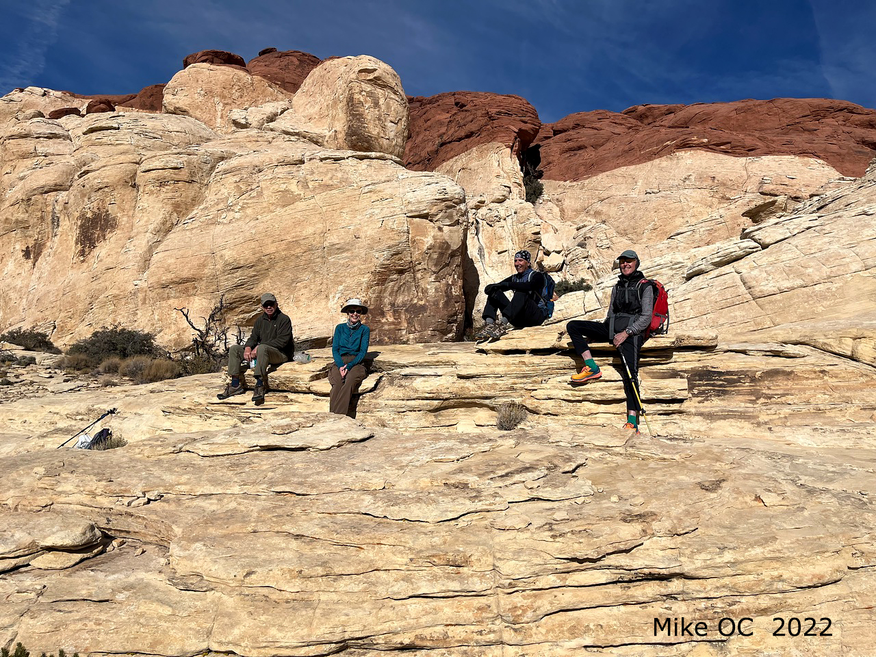
Brian Dodd and friends (especially Chuck, Larry, Terry and Jeannie) have been leading hikes out at the Valley of Fire (VoF) for the interpretive park rangers, once a month during the season, for about half a dozen years.  If you are interested, they are announced and posted on the VoF Facebook pages a week or so beforehand.  Developing new hikes that are appropriate in distance, gain, terrain and of interest for a group of ~20 folks of unknown hiking capability requires some work.  Brian and co., have explored and led hikes to high points in the rockpile near the Beehives for several years. 

      However, the question was, is there a hike out there suitable for a public park hike?  So, on Friday November 18th, four friends went out to pre-hike a possible route.  It was overcast and not as windy and cold as expected…in fact a perfect hiking day.  The first part of the hike was pretty routine with some steep rockfall climbing to the first highpoint HP-2595, continuing down and around to the second highpoint at HP-2617.  There’s an ammo box sign in book up there now.


Larry at High Point Two
The problems came around HP-2670.  While there’s a little exposure getting up there, coming down requires a mini, free rappel.  This was deemed to be too dicey for a park hike, so alternative work arounds were explored which didn’t go all the way up and came down different ways.  The intrepid explorers split, with one pair going down a nice canyon, only to find that they were eventually cliffed out.  This required them retracing their path and coming back up again.  Did we mention new hikes take work to develop?  The other pair went down the usual route, but were soon reminded that further down there was another drop requiring some strength and agility…again probably not suitable for a park hike group.

Brian’s pair went on to the next high point at HP-2304, not really expecting to see the others until they were back at the car.  Over to HP-2304 is an out-and-back section and while coming back, lo and behold the other pair were seen way across the gap.  A quick phone call told them to stay there, where the group will be re-united.  On the way back to join them Brian decided that this hike was altogether too much hard work for a park hike!  Either that or he was totally out of shape…

"Where shall we go next?"
Back as a foursome again, the trek continued uneventfully to the last high point, HP-2561, where there are great views to the south.  From there on, it was a decent, mostly downhill route back to the parking lot.

Once back home Brian cut and pasted tracks to continue to develop a park hike that will eliminate the HP-2670 tricky rappel and the HP-2304 hard climbs and descents…but which might include P11b-2600.  However, these options will require another pre-hike.  Did I mention that developing a good hike takes work?
Larry near High Point Three

Coming down the mini-rappel (Harder part above)

Finding the separated Climbers "Over There"


Tuesday, November 22, 2022

Lone Mountain East Face - 11/22/22

Climbing the East Face of Lone Mountain

 You knew I couldn't stay away from the blog for very long! Mike sent this photo from Lone Mountain today. Four hikers climbed up on the east side. It is a steep but very doable scramble up 900' in one third of a mile. The plan was to descent on the south side but I didn't receive any photos of that. We used to do this several years ago but we can't say what the trail conditions are like now on that side of the mountain.


Wednesday, November 16, 2022

Blogger - 11/16/22

Rainbow Gardens and Lava Butte (2010)

Hello Everyone!

     I had knee replacement surgery on Friday, November 11th. It's been a little bit of a rocky road but I am back on track to recovery. Please continue to freely browse the blog and I will get back at it as soon as I am able. Thanks for all your support! K

Please send comments to my disposable email (kneereplacement2022kay-comments@yahoo.com). Thanks.

Monday, November 14, 2022

Oak Creek Canyon Loop - 11/10/22

Oak Creek Canyon

Oak Creek Canyon Colors

Oak Creek

Middle Oak Creek Canyon Trail
It was a little chilly as we stepped out of the car in the Scenic Loop exit parking lot but it warmed up quickly as the sun rose. Crossing the Red Rock Scenic Loop, we chose the second trail from the left. There are so many trails leading out from here that it is important to find correct trails. Some of the trails lead to the same place but some don't. Our trail led us one mile into the desert at the base of the escarpment hitting a dirt road. We turned right onto the dirt road, known as the Middle Oak Creek Trail and continued toward the escarpment in front of Rainbow Peak. As we hiked, the trail became rockier and rockier. It gives you a couple of choices but essentially, you want to end up between Rainbow Peak on the right and Oak Creek on the left. There is a lot of red dirt here and is known as "The Red Dirt!"

Reading the Knoll Trail Sign

Rock Climbers on Rainbow Peak

Starting into Oak Creek Canyon

 Trail leads up by the Wall
Continuing on the trail down and over sandstone rocks, we did a little easy scrambling. Above us on the wall called Solar Slab, there were several climbers. The climbers like this wall because it is in the sun for most of the day in the winter. Our trail came to a place where it appears that it may turn right up some rocks. Don't turn right here but do go forward just a tad more and turn right to scramble up to a large tree and boulder at Rainbow Peak wall. The trail continues along the wall in the sun until, finally at the end of the trail, it decides to turn down toward Oak Creek. Again, look for a large tree and boulder along this trail toward Oak Creek and soon you will find yourself dropping into the Sandstone boulders.

Scrambling starts in Oak Creek Canyon

Canyon Sandstone

Turnaround Point

Trail between two Boulders
Oak Creek is unique in that it has huge boulders with round corners leaving very little to grab onto when scrambling up. Requiring use of the whole body at times, it is a lot of fun. We scrambled up the dry creek bed, and I had to climb up and around into the woods on the left side once.  About a 1/4 mile up, we found the "pond." This is a small water hole on top of a large boulder. Not far past this point, there is an area of huge boulders that I don't know the secret to. Maybe the scramble continues up and around on the right side. So here, we rested and took our break and photo. In just a few minutes, we were scrambling back down the boulders. This endeavor was much easier than the ascent. The important thing is to remember which way you came up before. Mike and Ralyn came down through the middle all the way. Rita and I found a cairned trail on the north side that took us to the junction with the trail we came in on.

Large puddle in Colorful Section

Large Puddle in Colorful Section

On the Trail toward Potato Knoll
Returning to the place we came into the creek, we continued down and passed through a very colorful area with a red wall. Just past the wall, we dropped down off of a huge orange boulder. Here, we turned to the right and began the trail that heads toward Potato Knoll. The trail is one of many and not marked, therefore, just hike toward to hill as best you can. After reaching Potato Knoll, the trail leads around the hill on its left (north) side. Ideally, you will cross Oak Creek 3 times and continue up the berm on the left. I never do this section the same and oftentimes I learn ... or relearn ... how to navigate. Find a trail that will then climb up the berm on the north side of Oak Creek and lead you out to the road called Middle Oak Creek Trail. Turn right and take a quick left to get onto the trail leading back to the cars. We had a fun day.

Stats: 6 miles; 600 feet, 4 hours

First Oak Creek Crossing

Last Oak Creek Crossing

Western Bluebird