|
| Lava Butte from Crest Trail |
 |
| Ten Falls Canyon from Crest Trail - Virgin Peak range Beyond |
 |
| Lava Butte from the approach Canyon |
 |
| Seven Hikers starting out up the Main Wash |
So, what happens when two hikers want to go easier and the rest of the group wants a challenge? We went to Rainbow Gardens, the area surrounding Lava Butte. We entered into this area on Lake Mead Blvd. to the north of Frenchman Mountain where the Great Unconformity lies.
This is a contact between much younger rocks deposited directly on older rocks where the intervening rocks either were never present or were removed by erosion. Frenchman Mountain began its travels from Gold Butte as part of the Virgin range. With the movement of the Lake Mead shear zone, it travelled southeast through Bitter Spring Valley (13 million years ago) shedding debris and ended up where it is today. Its travels are not over.*  |
| Approaching Bed Springs Junction |
 |
| Wardrobe change at Bed Springs Junction |
 |
| Climbing up through the Lava Butte approach Canyon |
 |
| Hikers above approach Canyon from Crest View |
As we neared the large dark peak of Lava Butte to the right, we drove through
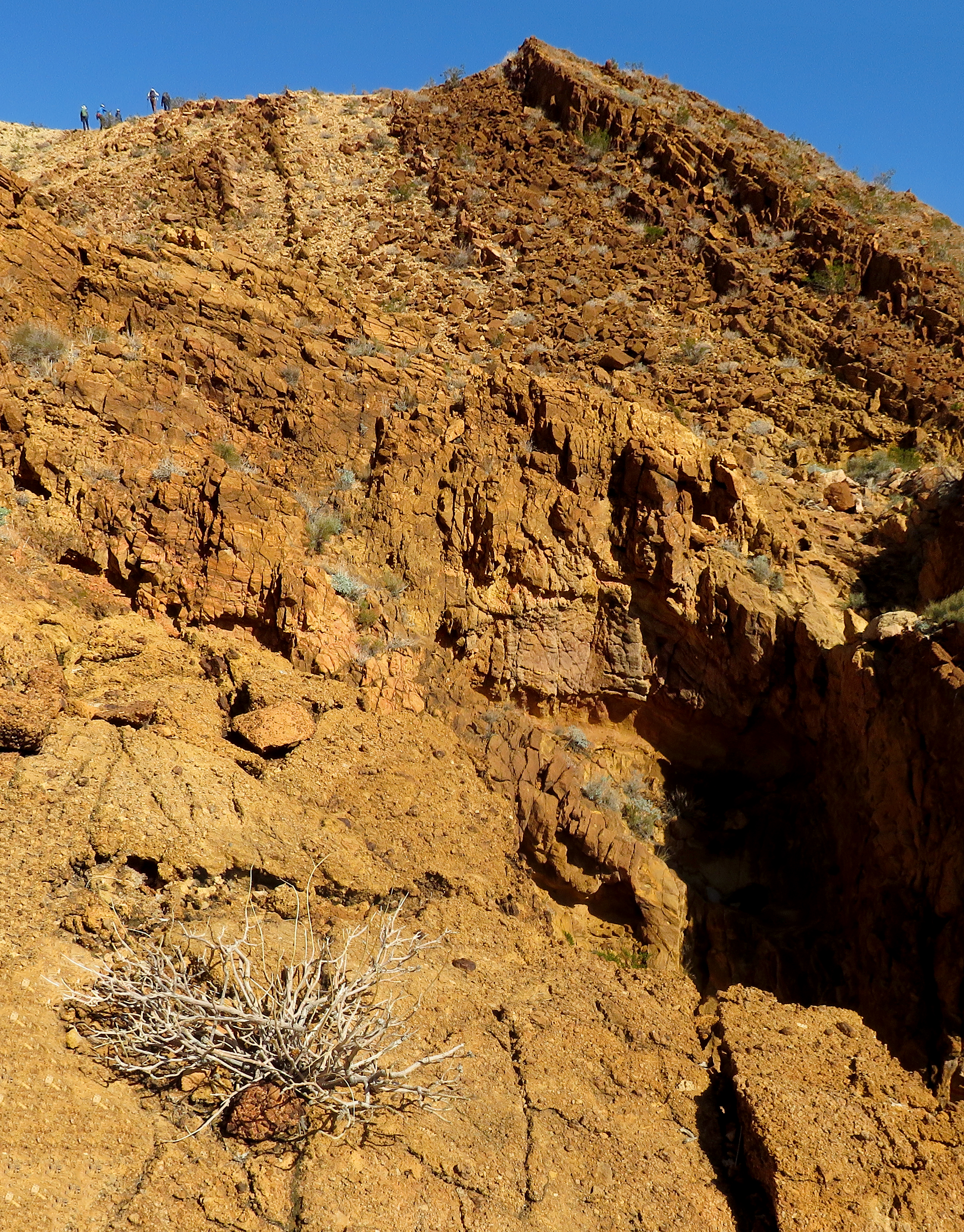
an area of Aztec Sandstone, an extensive unit of ancient lithified dunes found throughout the southwestern U.S. that formed in an environment much like the modern Sahara Desert. The low ridge between the highway and Lava Butte has red Aztec Sandstone cropping out at its base and is capped by the Rainbow Gardens Member of the Horse Spring Formation (the oldest member of the Horse Spring, it was deposited at least 17 million years ago). The Rainbow Gardens Member of the Horse Spring Formation takes its name from this area and, in turn, provides much of the color.*In the middle of all the color of Rainbow Gardens is Lava Butte. Lava Butte is not a volcano. Recent mapping has led geologists to interpret it as a small volcanic plug that came up through the Horse Springs Formation, forcing its way laterally along the formation for a short distance at one or more horizons. It now stands up as a prominent peak above its surroundings because it is composed of rocks that are more resistant to erosion than the soft sedimentary rocks that it forcefully penetrated.*
*Geologic Tours in the Las Vegas Area (Expanded Edition with GPS Coordinates), Nevada Bureau of Mines and Geology Special Publication 16, University of Nevada, Reno, Mackay School of Earth Sciences, 2008, Bear Printing, Sparks, NV; pages 59-61.
 |
| Climbing to Lava Butte boulder field Base - Crest rising Beyond with Rainbow Gardens Canyon Below |
 |
| Rita on steep climb south of approach Canyon |
 |
| Rita and Kay's climb to Crest Trail |
 |
| Crest View of Lava Butte Climbers |
So, after an effort to superficially explain all the geology of Rainbow Gardens in a tiny nutshell, we parked at Northshore Road mile marker 2 and began our hike toward Lava Butte up the main wash. Our traditional hike follows the main wash up to what we call Bed Springs Junction. This is the top of a small ridge among the arroyos where old miners' bed springs lie about. A right turn on the ridge led us up to a flatter ridge where we turned to the right and headed up the break in the terrain we will call the Lava Butte approach canyon. From the beginning of the hike, we had beautiful views of Lava Butte on a gorgeous day! It was at this canyon's dry fall that the two groups of hikers separated. The summiters climbed up the right side (or scaled the wall in the middle!) and the Crest Trail hikers (Rita and I) climbed up the left side of the canyon. We watched as the other group of five hikers climbed on up to the base of a boulder field with an approximate incline of 45°. Up they went from there. As we hiked on around the overlooking terrain crest, we watched the climbers until they were hidden behind a small ridge.
 |
| Lava Butte climb in a Nutshell - Steep and Beautiful - Worth it! |
 |
| The back side of Frenchman Mountain |
 |
| Lava Butte from Crest Trail |
 |
| Arriving at the previous Snack Break Saddle |
Our route had climbed up and around the crest to the trail that drops down to the base of Lava Butte. Here, we noticed that someone has raked the trail on a route that we have used before along the crest. It looked inviting and we followed it around, taking views back to the butte, to the snack break saddle we have used several times in the past. Not ready for a break, we continued following the trail to a crest saddle. Here, we could see the splendor of a large area of the Rainbow Gardens member of the Horse Spring Formation. As Rita and I always do, we saw a new trail and decided to take it! I believe the crest trail that we explored has been there for quite some time but we have never used it. The trail climbed up from the saddle, waded through a rocky area and perched onto the ridge crest above high cliffs.
 |
| Following Crest Trail above Ten Falls Canyon |
 |
| The Lava Butte Crest Trail - Lake Las Vegas Beyond |
 |
| Crest Trail along Cliffs |
 |
| Kay on the Crest Trail |
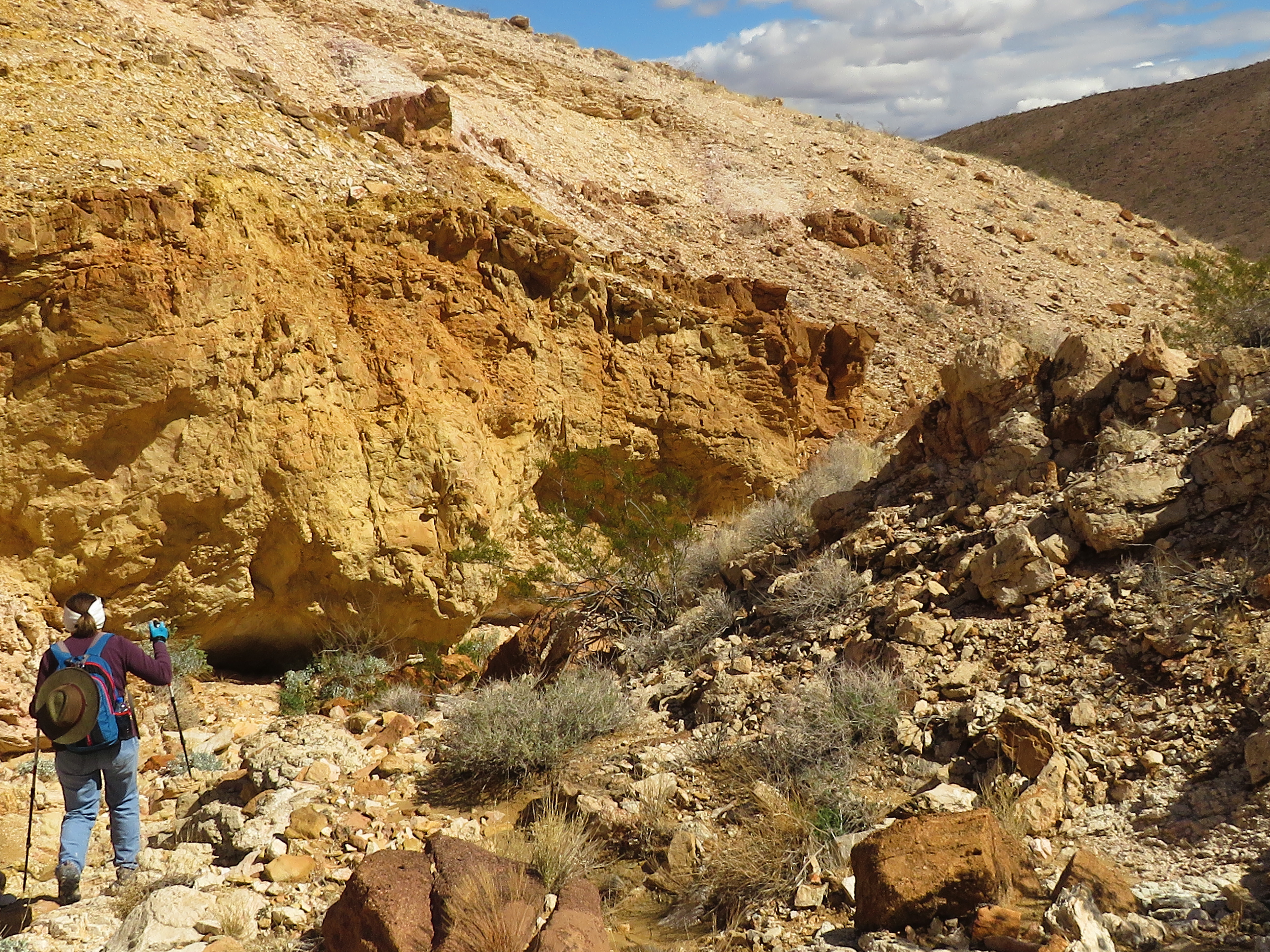
Ten Falls Canyon was below us on the left. Lake Las Vegas could be seen in the distance. And, Rainbow Gardens dropped colorfully on the right side. Following the trail, we found a couple of places to descend down to Ten Falls Canyon where we knew there were nice dry falls to play on. We descended on a ridge and continued down the canyon. Finally, we reached the bottom of the canyon where we junctioned with the bottom of Rainbow Gardens Canyon. This small colorful canyon represents a lot of the color found in this area. Our inclination was to hike up through the small canyon but we decided not to since we wanted to meet up with the summiters on their way down. We chose the trail that ran straight across from Ten Falls Canyon's mouth.
 |
| Rita dropping into Ten Falls Canyon |
 |
| Rita negotiates a Dry Fall in Ten Falls Canyon |
 |
| Beautiful Geology in Ten Falls Canyon |
 |
| View up Rainbow Gardens Canyon |
The trail led us through a narrow wash and up to Bed Spring Junction. Staying in contact as best we could, we knew that the summiters were on their way down so we headed on down the main wash to the cars. When we reached the trailhead, it wasn't two minutes before the summiters were hiking in. Good timing! All hikers were anxious to tell their tales. A good time was had by all! And, did I mention that it was a beautiful day!!
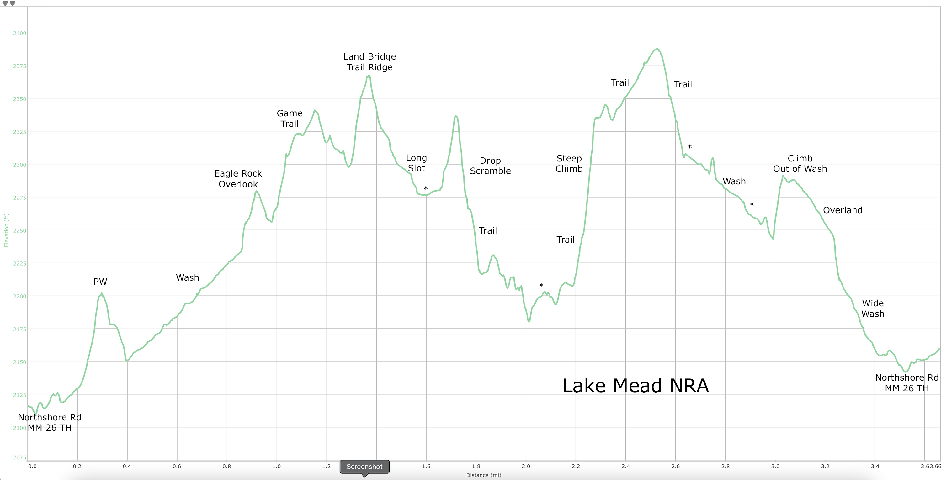
Stats: ~ 5.2 miles (for both groups); 700' gain (for Crest Trail hikers); 3.75 hours (for both groups)
 |
| Taking trail to Bed Springs Junction |
 |
| Following Trail through Main Wash |
 |
| Colorful Lava Butte view from Main Wash |
 |
| This route for Lava Butte summit climb reflects only one possibility. |