Sunday, November 17, 2013

SE Damsel Peak - 11/16/13

Damsel Peak with Pincushion Pinnacle

Laszlo with Mount Wilson in Background
 Two of the Around the Bend Friends club members had quite an adventure on Damsel Peak on Saturday. Jerry provides the photos, the story and the GPS track. He and Laszlo had a tough but fulfilling day as described below.

Laszlo and I decided to conquer Damsel Peak yesterday.  We both wanted to climb the mountain for a long time.  It was taunting us everytime we drove home since it sticks out right in front of you as you drive up Thomas Ryan Drive in Sun City.  We had only one day we could do it.  We could not find anyone to join us so we decided to go off on our own.  We started at about 7:30am from the dirt Kraft Mountain parking lot in Calico Basin. The only other way to get close to the mountain is to drive on private property.  Our route stays on BLM land the whole way.  This made the approach to the mountain much longer.  It took us almost two hours hiking across the desert just to reach the mountain. 

Jerry and Laszlo on the Summit

Turtlehead Peak in Late Afternoon Sun
 We were following a track from one of my mountaineer friends but as it turned out it was probably the worst route up the mountain.  The way up was very steep with lots and lots of loose rock and scree.  It was the most horrible terrain to hike on imaginable.  Did I mention that there was lots of scree?  We made it past the Pincushion Pinnacle which Laszlo had named the "thumb" and up to the summit which I found out later is called "Southeast Damsel Peak".  We were running out of time so we did not make it to the slightly higher peak called "Damsel Peak".  We started down around 12:15 and took a much more direct route down although it was still very loose rock, scree and sharp limestone.  We reached our vehicle about 4pm as the sun was starting to disappear behind the escarpment.  I would not recommend this peak to anyone else unless they are simply suicidal.  Evidently most other people agree with this assessment since the log book had only 5 names in it for 2013 (that includes me and Laszlo). ~ Jerry

"Terrible Traverse" with Summerlin Peak in Background


Saturday, November 16, 2013

Escarpment Base Trail - 11/16/13

At the Base of the Red Rock Canyon NCA Escarpment

Trail View of Turtlehead and the Calico Hills

Arnight Trail
 Sixteen hikers ushered in cooler air today as they hiked through the heavy gusts of wind descending upon the Las Vegas alluvial fan. Our route, named the Escarpment Base Trail, was a point to point hike from the lower end at the Oak Creek Trailhead to the upper end at the Lost Creek Trailhead on the Willow Springs spur road. We drove the Red Rock Canyon NCA scenic loop around to Lost Creek, consolidated our carpools then drove everyone down to Oak Creek where the Arnight Trail begins. Arnight Trail, Pine Creek Trail, Dale's Trail and SMYC Trail would all participate on our route du jour.

Arriving at the Old Wilson Homestead

Mescalito Peak from the Wilson Homestead

Wilson Oven at Pine Creek
 We began hiking out Arnight Trail which is covered with loose rocks that required dodging. We passed the Knoll Trail and spur to the Fire Ecology Trail turnoffs and continued down to the old Wilson homestead located in Pine Creek Canyon. As we took a small break on the old foundation, Chris told us the story about the Wilson family living here growing fruit and vegetables with the water of Pine Creek until the need to be closer to town became apparent. On our way to the Dale's Trail junction, we passed by their rock oven and their front entrance pillar.

Hiking the Rock Garden Named Dale's Trail

Pinion Pine and Juniper

Dale's Trail
Dale's Trail is one long rock garden filled with colorful boulders and various types of cacti. The escarpment provided an overlooking backdrop and the dirt under our feet was tinted red. There were several washes that we had to cross by dipping down and back up but emphasis was placed on the "back up" part as we gained elevation throughout the hike. We stopped at a place where a park bench had been placed for our long break. It was evident by the disturbed dirt and hoove prints covering the area that bighorns gathered there recently.

Turtlehead from the Snack Spot

Climbing Up to Cross Ice Box Canyon

SMYC Trail
 After the break, we continued on Dale's Trail until we passed through the Ice Box Canyon wash and crossed over the several trails that service the canyon. By hiking in somewhat of a straight line, we connected with the SMYC Trail next. This trail is no less beautiful. It takes the hiker along an area of the escarpment that houses an old mountain lion den that is occupied from time to time. Finally, we arrived in the Willow Springs area after 5.5 miles. We gained 1145 feet in elevation during the hike but only lost 575 feet since Lost Creek is 570 feet higher in elevation than Oak Creek.

Old Mountain Lion Den

Willow Springs and White Rock Hills


Thursday, November 14, 2013

White Rock Springs Peak Loop - 11/14/13

White Rock Springs Peak (Left Peak)

Tunnel Vision Peak from White Rock Springs Climb

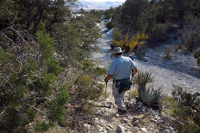
Scrambling Up the Backbone Ridge
Just when you think that you have seen the best views that Red Rock Canyon NCA has to offer, you are introduced to a new hike! Eighteen hikers (with a few newbies) drove up to the White Rock Springs Road on the Scenic Loop of Red Rock and parked at the lower parking area. We welcomed the walk up the road to warm the muscles, took a short break at the restroom then began our climb up the rocks.

White Rock Hills Peak from White Rock Springs Climb

La Madre Range from Climb

Reaching the First False Peak
 White Rock Springs Peak is located on the north end of the White Rock Hills. There is a long ridge rising up from the upper parking area of the short spur road. Our climb up this ridge contained a lot of scrambling and we gained altitude fast. The views of the surrounding landscape were open and beautiful. We passed one false peak as we reached the upper lateral ridge and the rest of the approach to the secondary peak was relatively flat.

Backbone Ridge Ascent to Calico Hills

Three White Rock Hills Peaks (L-White Rock Hills Pk, Ctr-White Rock Springs Pk, R-Secondary Pk)


Approaching the Secondary Peak
 The difference in altitude of the premier peak and the secondary peak is only around twenty feet. Nevertheless, the log book is located on the highest peak so off we went. Making a 90 degree left turn at the secondary peak, we began a precarious traverse over to the rock outcropping about 25 yards away. The scramble over to the peak involved either balancing over the top of small rock cliffs or hiking down and up to get around them. Each of us chose our route with advice being yelled in every direction!

Beginning Precarious Traverse from Secondary Peak

Turtlehead, Las Vegas Strip, & Calico Hills

Colorful Rock and Saddle Below
 Finally, we reached the premier peak and signed in. The views were, again, fantastic! There were steep cliffs below us just about everywhere we looked. The La Madre Range towered above us and we enjoyed a nice break. We finished our snack and began reversing the precarious traverse. (If you choose to go up and over the small cliffs, just be careful of those rocks above your head!)

White Rock Springs Peak Summit

A Few Hikers on the Summit

Kay Made it Down!
 To the left, there is a photo of Kay sticking her landing from a down climb that George is beginning above her. Just behind them, Mike found that big rock at head level and when most of us reached the secondary peak on the return, Mike was being attended to with a one inch head gash. A little blood, a few bandages and we were all on our way again going down the north side of the hill. This down scramble was evidently seldom used as the trail was basically a game trail and the rocks and dirt were undisturbed for the most part. Since we were blazing the trail, there were a few slips and falls but no one got hurt except for minor scrapes and cactus needles.

Photo from Precarious Traverse

Steep North Side Descent

Finishing Descent on a Large Sandstone Slab
 Finally, we found ourselves at the top of a very large sandstone slab area. Random hikers below us were yelling up to us to ask how we got where we were. (This couldn't be good!) Nevertheless, from this point, the descent became easier and the wash at the bottom appeared. We turned right in the wash, climbed up to the White Rock Hills Loop Trail, followed it for a while then dropped into the wash again. The wash led us to the upper parking area of the White Rock Springs Road and another half mile or so down to the lower parking area.

A fantastic loop hike of 4 miles with 1700 feet of elevation gain over the course of 5 hours.

White Rock Hills Loop Trail

White Rock Hills Wash


Tuesday, November 12, 2013

Juniper Peak - 11/12/13

Las Vegas from Juniper Peak

Juniper Peak & Rainbow Wall
 There is a peak in the Red Rock Canyon NCA escarpment that lies between Rainbow Peak and Bridgepoint Peak called Juniper Peak. It is surrounded by other grand displays such as Rainbow Wall and Mescalito Peak as well. Seldom is Juniper Peak talked about but today she was the star! Eighteen hikers began at the Pine Creek Trailhead and hiked out to Juniper Canyon by way of the Pine Creek Trail and the Arnight Trail. Upon arrival at Juniper Canyon, a festival of large boulder scrambling ensued. There is really just one route up through the boulders, but the writer (who was not there) bets (OK, this is Las Vegas) that different routes were tried. After reaching the top of the boulder field, a slippery dirt hill had to be climbed. Then comes a rock fall ... then the Great Juniper Canyon Sandstone Slab. This is where the story from Steve and Laszlo began. Their photos and a few words tell the tale.

The Sandstone Slab

Don Climbs Above the Slab

Hikers Rally to Help Don
The diagonal sandstone slab after the slippery dirt slope that preceded it, was welcome terrain (for the most part!) Then, we saw Don P. heading into perilous territory as seen above. A few friends helped him out of a tight spot and the group proceeded up to the summit where there was a dynamite view as we ate our lunch. On the way down we met up with a hiker who was coming up and we wished him well after a small chat. ~ Laszlo

Jerry Surveys His Next Move

A Crowded Summit
 After climbing the sandstone slab, Mike OC led the group up a steep rock ramp and turned left. The trail continues up next to the wall that supports the peak. A little bit of twisty route at the top of the wall then you are climbing up through a rabbit hole and around to the peak. (On the way down, some hikers choose to forgo the rabbit hole and go straight down over the edge next to it as seen in a photo below.)

Juniper Peak View of North Blue Diamond Hills

Alternate Descent Instead of Rabbit Hole

Bottleneck Down a Steep Ramp
Although Laszlo is a man of few words today, suffice it to say, the eighteen hikers appear to have had a fun and adventurous day.

The 5 mile hike contained 2100 feet of total elevation gain and lasted just over 4 hours.

Meeting Another Hiker on the Slab Descent