 |
| Saddle Overlook of Spring Mountains |
 |
| View of Descent from Saddle |
 |
| Mile Marker 4 Trailhead View |
 |
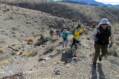
| Starting up the Ridges & Washes |
The Desert National Wildlife Refuge is the largest wildlife refuge in the continental United States. It is located due north of Las Vegas, Nevada. There are very few feasible day hikes in the refuge due to lack of roads. The roads that are within the refuge's boundaries require high clearance vehicles at best. Today, we discovered a day hike that we had overlooked in the past. We are calling it First / Corkscrew Canyons Loop. Fifteen hikers hopped in 4 high clearance vehicles with pretty good tires and drove out to the Corn Creek Visitor Center to sign in.
 |
| First Canyon from Distance (near center of photo) |
From there, we turned right onto the Mormon Well Road and drove approximately 4 miles. Here, there is an unofficial parking area off the left side of the road.
 |
| Taking in the View |
Corkscrew Canyon is located on the back side of Yucca Peak. First Canyon lies parallel to the southeast along the base of the mountains.
 |
| One More Wash |
 |
| First Canyon Entrance |
There are alluvial fans flowing out from the mouths of the canyons and these washes and ridges were our approach terrain from the trailhead. There is no way to avoid the traipse through the desert but, this morning, it was an oddly beautiful experience. The weather was slightly crisp and the sky was filled with fluffy clouds. Behind us, we had a theatre view of the snow covered Spring Mountains. We have had a ton of snow this year! ... Okay, tons. And, most of all, the group of fifteen hikers were all excited about the upcoming exploration. Ready for just about anything!
 |
| Entering First Canyon |
Whenever possible, we would climb the easy footing of the ridges and finally, we arrived at the entrance to First Canyon.
 |
| Making an Immediate Left Turn |
It would be difficult to describe the canyon entrance from a distance. We had the advantage of a GPS with a track.
 |
| Starting into Meander Canyon |
 |
| Another Corner |
We were surprised at the large width of the canyon and we could see that it continued up for some distance. However, our route brought us to the first canyon turning off to the left. This was a more narrow canyon with very high cliffy walls. Suddenly, we were surrounded by 5000 foot mountains rising about 1000 feet above us. It was enchanting. This canyon began a serpentine climb up through gravel. And, we dubbed the canyon route from First Canyon to the upcoming saddle, Meander Canyon.
 |
| The Saddle Area comes into View |
There was a canyon junction where we stayed to our left. This turn brought us to a smaller canyon that contained a few small dry falls. The moderate type scrambles added interest, not danger.
 |
| Climbing the First Small Dry Fall |
After a dry fall that only three of our hikers tackled (the rest of us went up and around), a smallish wash turned up to the left.
 |
| The Second Dry Fall (Most of us went around.) |
 |
| Climbing the Last Wash to the Saddle |
We could see above that we were below the saddle area. The cliffs had lowered and there were interesting red pinnacles climbing up toward the ridge line. We turned left to climb up the small wash. Although it was tempting for several hikers to side-step the center of the wash, the rocks were easily climbed within it. It wasn't long before we were cresting the saddle and, oh, what a grand view! Immediately, the fifteen hikers turned to the left where a few more steps up put us on an overlook.
 |
| Grandiose Saddle View toward Corkscrew Canyon |
The Spring Mountains rose across the Upper Las Vegas Wash and the I-95 corridor. Immediately below us, a canyon dropped precipitously. Since it appeared as a dent in the mountains, we called it Dent Canyon.
 |
| Discovering the Overlook above Dent Canyon |
We were so in awe of the view, we decided to take our break here. We had climbed 1400 of our total 1700 feet in elevation gain up to this point.
 |
| Group Shot at the Saddle |
 |
| Dropping down the Small Wash to Corkscrew |
High mountains rose up all around us on the non-view side. We noted a game trail on the other side of the descent wash. Yes, there is wildlife in the refuge! After our break and a photo, we started down the other side of the saddle wondering what we would encounter. The wash was small and a little brushy. There were a few small dry falls before the drop into Corkscrew Canyon. The last ones were the most interesting but there wasn't anything that was higher than 4 feet. Piece of cake!
 |
| Small Dry Falls |
At the Corkscrew Canyon junction, a pinnacle rose out of the canyon and a couple of hikers tried to climb it. It turned out to be a bit crumbly. Not a good idea.
 |
| A "Family" of Cotton Barrels |
Up canyon was a fairly straight shot up into the mountains ending at the base of Yucca Peak.
 |
| Red Barrels covered the South Facing Wall of Corkscrew Canyon. |
 |
| Starting down Corkscrew Canyon |
Down canyon was the interesting part. The reason for its name. As we started down, we noted that the south facing walls were absolutely covered with red barrel cacti. The north facing walls had none. The walls were almost black in color and contained many "fins" of outcroppings. Without the sun in the canyon, it was difficult to get photos that might show the anomalies. We descended happily through the gravel between the high walls that were approximately fifty feet apart and swerving right and left.
 |
| Sunlight and Dark Walls |
We kept trying to compare the canyons to other canyons we had visited in the past. It was definitely different than just about anything else in the Las Vegas area that we had seen.
 |
| One of Many Twists and Turns |
As we came out through the mouth of the canyon, we turned around the corner to the right. Our original plan had been to inspect Spot Canyon next door. Plans were changed as we realized that the dark cloud above us may not cooperate.
 |
| Corkscrew Canyon opens out into the Desert |
 |
| Exiting Corkscrew Canyon |
So, we started our 2.5 mile journey over the alluvial fans of washes and ridges back to the cars. Not sure if it was the best plan but we made an attempt at a beeline route back. This meant that we had to undulate constantly over the ridges and down into the washes. We all seemed to have enough spare energy to handle this quite well. Everyone had a wonderful morning exploring at the refuge and said that this hike should be repeated. (It never did rain.)
7 miles; 1700 feet elevation gain; 3.75 hours
 |
| Starting back across the Desert |
 |
| Dark Clouds Threaten |
 |
| Beeline for the Trailhead |


No comments:
Post a Comment