 |
| A View down Hummingbird Gulch |
 |
| Mummy's Toe from High Point Corner |
 |
| Hummingbird Gulch (L), Robbers' Roost (R), High Point Corner (Top R) |
 |
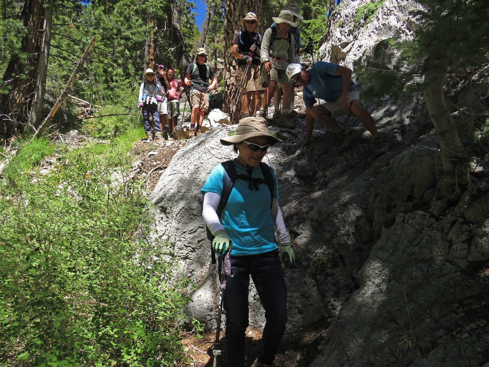
| Climbing the Gypsy Bike Trail |
The area around the North Loop Trailhead of the Spring Mountains NRA is teeming with hiking and biking trails. Today, we put together a loop that started at the Robbers Roost Trailhead and ended with a descent in the ever fascinating Hummingbird Gulch. From the trailhead parking lot, ten hikers crossed the road and climbed the small hill. At the clearing, we turned to the right to begin hiking through a mountain mahogany tunnel. These trees are blooming right now with little wispy feather-like fluffs from every leaf. They produce a ghostly glow when the sunlight shines through them.
 |
| View down Telephone Canyon |
After rounding a curve to the right, we came to an elusive spot. I had recently placed a cairn here but the cairn monster has been by and it was flattened. Anyway, there is a right turn here to take you up the old Deer Creek Road remnants.
 |
| Nearing top of Gypsy Bike Trail |
At one time, this old road trail was dubbed the Cucamonga Trail after the bike park in California. Now, parts of the trail are named the Gypsy by the bikers that use these trails.
 |
| Hummingbird Gulch & Trailhead from Deer Creek Road |
 |
| Climbing the North Loop Trail |
So, we followed the Gypsy (Old Deer Creek Road) up paralleling the new Deer Creek Road enjoying the wide views of Telephone Canyon and seeing Hummingbird Gulch across the way. The climb is gradual and was easy on the morning lungs. We didn't see any bikers but we did see several bike jumps as we passed. Eventually, we came to where the trail meets the paved road and we walked up the side of the pavement to the North Loop Trailhead. After a short breather, we started up the North Loop Trail. Soon, we were spread out just a little and we all gathered at the "Meadow."
 |
| Resting at the North Loop Meadow |
The Meadow is the wide open saddle that you reach after about 1.3 miles of climbing. It is a great place to rest and enjoy.
 |
| Mummy's Nose from Meadow |
The prominent pointy peak that watches over the Meadow is Mummy's Nose. We rested up for the remaining part of the climb.
 |
| Starting up the North Loop Switchbacks |
 |
| Break at High Point Corner |
The next 0.8 miles consists of 12 switchbacks. At the top, the trail makes one more switchback as it rounds the ridge corner on a high point. We stopped here for our break at 3.7 miles into the hike. It had been a long time since I had been able to stop here and see what could be seen. The little rocky corner offers nice views of Fletcher Peak, Griffith Peak and Hummingbird Gulch below. There are also many convenient places to sit. It was a little cool up here at 10,020 feet so some hikers preferred to sit in the sun. We soaked up the coolness!
 |
| Griffith Peak from High Point Corner |
Next on the agenda was a small drop down the North Loop Trail to the Fletcher Peak Trail junction. We turned left and left to switchback onto that trail to the peak.
 |
| Fletcher Peak Trail Saddle and Upper Hummingbird Gulch Below |
It was nice to go down this trail to the saddle knowing that we would not have to come back up like we usually do! Reaching the Fletcher Peak Trail Saddle, we had a clear view of
Charleston Peak on our right. Hummingbird Gulch dropped down to the
left. There is a large beautiful uprooted tree root facing the trail
here. This is a good landmark for where the trail down the gulch begins.
 |
| Fletcher Peak |
 |
| Approaching Saddle and Gulch Junction |
Although I had both gone up and gone down the gulch only twice before, this was the first time I had led the charge either way. In retrospect, I think it was very good that I had done the trail before since I now knew what to look for in a couple of critical places. The trail starts down a pine cone filled ravine; sometimes in the wash
and sometimes to its side. There are cairns that popped up often that
reassured us. The first half of the 1.5 miles of gulch led us through the trees. It was very shady, cool and beautiful. After identifying the correct overlook rock above to the left, the trail dives into the narrows of the gulch.
 |
| Starting down Hummingbird Gulch Trail |
When we reached the narrows section, the walls rose high on both sides
but the wash continued between them with a small spring making the
ground mossy, grassy and muddy. It was here that we started noticing the
differences from the previous time we had been here (2 years ago).
 |
| Reaching the Narrows |
There have been a few downed trees that have blocked the path. But, in
those 2 years, trails have been made to bypass the trees in some way and
the trail survives. Another change is that some of the trail through
the bushes has been overgrown by recent new growth. Again, the trail
survives.
 |
| The Overlook from Trail |
 |
| Down the Small Rock Wall |
One particularly tricky part comes when you emerge from the narrows. A
steep drop mess confronts you. Take a look to the left. The trail climbs
up and around to drop on scree back to the wash. This is a somewhat
dangerous section. Please be careful. Not for beginners. As we dropped, the trail was clear to me ... again since I was somewhat
familiar with it. In some
places, I followed the most logical route and was rewarded with a cairn
further down. The scree was treacherous and it seemed like we all fell at least once! Finally, we reached the Old Deer Creek Road and turned left hoping that the road would lead us back to the Robbers Roost Trail. The road petered out and we had to drop down to the pavement below to finish the hike. Fun new route for strenuous hikers. Fun group. Tired now.
6.5 miles; 2100 feet elevation gain; 4.25 hours
 |
| The Tricky Part |
 |
| Tough Crowd on the Hummingbird Gulch Trail |
 |
| Following the Trail through the Scree |


No comments:
Post a Comment