 |
| Cairn on Cliff Edge of Escarpment |
 |
| Wilson Peak, Monument Peak & the Calico Hills from Mountain Spring Peak |
 |
| Colorful View Toward Pahrump Valley |
With long shadows describing the early hour, seventeen hikers set out from the Mountain Springs Pass trailhead for an 8 mile loop hike that would pass over Mountain Springs Peak and take us on an unprecedented tour of Mountain Springs, Nevada. We anxiously awaited the "go ahead" from our coordinator, Chris, to take off up the dirt road to the relay tower and on to the junction saddle.
We arrived at the saddle in small groups breathing hard. The short 1 mile climb of 1000' of elevation wakes us up every time. Most of the remaining 1200' of elevation would be gained in the next 1.5 miles. We climbed it with fresh smiles and loquacious conversations. Chris stopped a few times to make sure that everyone caught the left turns along the way.
 |
| Colorful Hills of Lovell Canyon |
 |
| Climbing the Trail to Mountain Spring Peak |
From the junction saddle, we turned left heading toward Windy Peak. After two or three more demanding climbs, we took a left fork. (The right fork continues around to Windy Peak.) The trail levels out a bit here as we wound our way around the side of the limestone escarpment. The views to our right were expansive showing all the southern peaks of the escarpment (Hollow Rock, Windy, Black Velvet and, eventually, Monument and Wilson.) Sandstone and Indecision Peaks were hiding low out of sight.
We had one more left fork to take which took us up steeply to the ridge. Soon after this, Mountain Spring Peak came into view. The limestone peak, seen in the photo to the right, is the highest limestone peak in this area of the escarpment and sits just behind the sandstone peak of Black Velvet. When we arrived on the summit, we signed into the log book and took our photos.
 |
| Monument, Black Velvet & Windy Peaks from Mountain Spring Peak |
 |
| View Toward Calico Hills from Summit of Mountain Spring Peak |
 |
| Seventeen on Summit |
The Las Vegas Strip was within viewing range, too, even though the dust over the city obscured the odd arrangement of buildings. We could, however, see the North Blue Diamond Hills, and the colorful Calico Hills. We were well aware that the national parks, etc., had been reopened this morning after a lengthy government shutdown. Everything was as it should be as we continued on the trail that followed the line of the escarpment.
As we lost around 200' of elevation on the cliff edge trail, we stopped to take in the excitement of standing on a limestone outcropping where there was probably a 100 foot drop, at best. When we reached our standard break spot, we found ourselves on another cliff that dropped even further. We spoke a little about the excursions that were being planned for the coming year.
 |
| Hiking the Escarpment Cliff Edge |
 |
| Checking Out the Cliff Below |
 |
| Taking Our Snack Break on the Cliff |
Just past the break spot, there is a small window through which one can see the Stratosphere Tower on the northern end of the Strip. After our break, we continued past the window, climbed up to the next ridge to the left and began dropping down balanced atop this ridge. The descent was easy here as the footing was soft and forgiving.
Dropping into a wash that junctioned with the main wash in this area, we hiked a long gentle descent in the easy thoroughfare. There were very few places where the wash would mildly be considered a scramble as hands were never required to negotiate the trail. Finally, at the cairns, we took another left fork into another, flatter, wash.
 |
| Hiking Down the Wash |
 |
| Nearing the End of a Long Wash |
This wash quickly dead ended into the Rainbow Springs dirt road (a high clearance road). We turned ... left ... and began a long one mile walk on the dirt road. It was slippery in several places and a few hikers almost hit the deck as tired feet made misjudgements on the banked curves. A small trail led up to the ... left ... and we explored a limestone cave then connected again with the road.
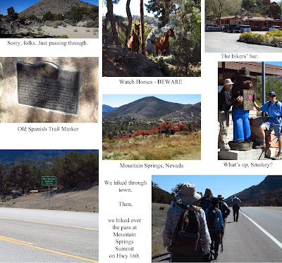
We followed the road past two of the springs for which the little town of Mountain Springs is named then entered into a horse laden residential area for a "tour" of the town. A paved road spit us out onto the main Highway 160 and we turned ... ahem, all together, ... left ... to follow the highway back to our cars. This last part of the hike is not recommended so the maps below show a previous route for the loop hike. Nevertheless, our happy go lucky bunch of fun hikers enjoyed the adventure and learned a few things along the way!
 |
| Crossing the First of Two Springs |
 |
| Crossing the Second Spring Area Above Mountain Springs, Nevada |
 |
| Our Interesting Tour of Mountain Springs, Nevada |


No comments:
Post a Comment